Épannes geodata
Épannes (Nouvelle-Aquitaine) is a populated place; located in France in Europe/Paris (GMT+2) time zone. With population of 740 people, there are 11290 cities with bigger population in this country. Compared to other cities in France, 63.1% of cities are located further ↑North; 84.3% of cities are located further →East and 93.9% of cities have higher elevation than Épannes. Note1
Administrative division(s):
- Level 1: Nouvelle-Aquitaine
- Level 2: Département des Deux-Sèvres
- Level 3: Arrondissement de Niort
- Level 4: Épannes


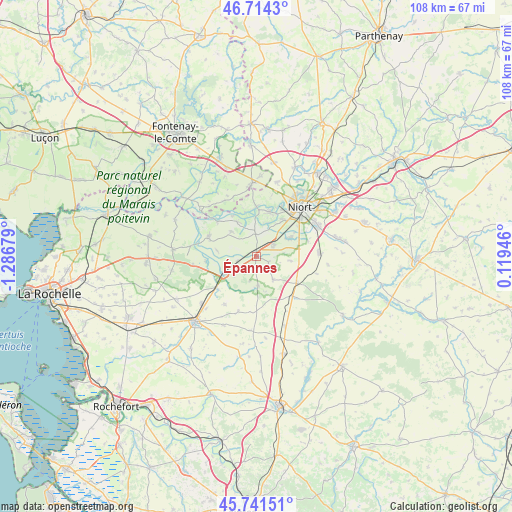
Épannes GPS coordinates[2]
46° 13' 48.216" North, 0° 35' 1.176" West
| Map corner | latitude | longitude |
|---|---|---|
| Upper-left | 46.7143°, | -1.28679° |
| Center: | 46.23006°, | -0.58366° |
| Lower-right: | 45.74151°, | 0.11946° |
| Map W x H: | 108.2×108.2 km | = 67.2×67.2mi |
| max Lat: | 51.07786° ⇑63.1% North |
| Épannes: | 46.23006° |
| min Lat: | ⇓36.9% South 41.3874° |
| min Long | Épannes | max Long |
| -5.08615° | -0.58366° | 9.52242° |
| W 15.7%⇐ | ⇒84.3% E |
Elevation
Elevation of Épannes is 20 m = 66 ft, and this is 173.7 m = 570 ft below average elevation for this country.
| Max E: |
2333 m = 7654 ft | 93.9% |
| Avg. | 193.7 m = 635 ft | |
| Épannes | 20 m = 66 ft | |
Min E: |
-1 m = -3 ft | 6.1% |
See also: France elevation on elevation.city.
Geographical zone
Épannes is located in North temperate zone (between Tropic of Cancer and the Arctic Circle). Distance of this North polar circle is 2260.9 km =1404.9 mi to North.| Distance of | km | miles | from Épannes |
|---|---|---|---|
| North Pole | 4866.8 | 3024.1 | to North |
| Arctic Circle | 2260.9 | 1404.9 | to North |
| Tropic Cancer | 2534.4 | 1574.8 | to South |
| Equator | 5140.3 | 3194 | to South |


Nearby cities:
15 places around Épannes: (largest is in red/bold)
• Beauvoir-sur-Niort
10 km =6.2 mi,  122°
122°
• Bessines
9.5 km =5.9 mi,  32°
32°
• Coulon
10.4 km =6.5 mi,  359°
359°
• Cramchaban
10.3 km =6.4 mi,  261°
261°
• Frontenay-Rohan-Rohan
4.3 km =2.7 mi,  54°
54°
• Granzay-Gript
7.9 km =4.9 mi,  100°
100°
• La Foye-Monjault
6 km =3.7 mi,  144°
144°
• Magné
9.9 km =6.2 mi,  16°
16°
• Mauzé-sur-le-Mignon
7.5 km =4.7 mi,  239°
239°
• Prissé-la-Charrière
11 km =6.8 mi, 144°
• Saint-Hilaire-la-Palud
10.6 km =6.6 mi,  290°
290°
• Saint-Symphorien
8 km =5 mi,  61°
61°
• Sansais
5 km =3.1 mi, 357°
• Usseau
6.2 km =3.9 mi,  177°
177°
• Vallans
2.9 km =1.8 mi, 121°
Sources, notices
• [Note1] Compared only with cities in France existing in our database
• [Src1] Map data: © OpenStreetMap contributors (CC-BY-SA)
• [Src2] Other city data from geonames.org with taken over terms of usage.
• [Src3] Geographical zone / Annual Mean Temperature by Robert A. Rohde @ Wikipedia
