Frontenay-Rohan-Rohan geodata
Frontenay-Rohan-Rohan (Nouvelle-Aquitaine) is a populated place; located in France in Europe/Paris (GMT+2) time zone. With population of 2,753 people, there are 3557 cities with bigger population in this country. Compared to other cities in France, 62.9% of cities are located further ↑North; 83.8% of cities are located further →East and 93.1% of cities have higher elevation than Frontenay-Rohan-Rohan. Note1
Administrative division(s):
- Level 1: Nouvelle-Aquitaine
- Level 2: Département des Deux-Sèvres
- Level 3: Arrondissement de Niort
- Level 4: Frontenay-Rohan-Rohan
Current local time in Frontenay-Rohan-Rohan:
12:17 PM, SaturdayDifference from your time zone: hours


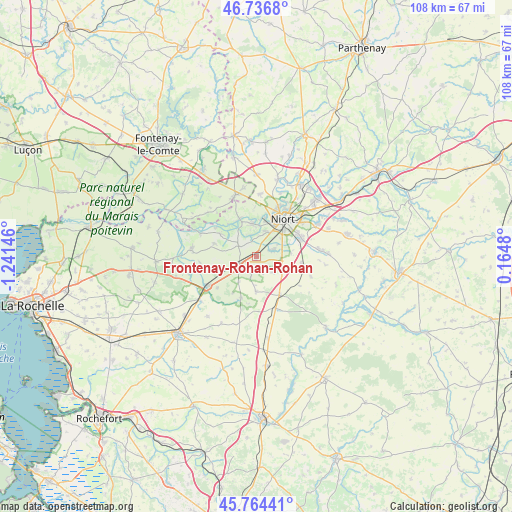
Frontenay-Rohan-Rohan GPS coordinates[2]
46° 15' 9.936" North, 0° 32' 17.988" West
| Map corner | latitude | longitude |
|---|---|---|
| Upper-left | 46.7368°, | -1.24146° |
| Center: | 46.25276°, | -0.53833° |
| Lower-right: | 45.76441°, | 0.1648° |
| Map W x H: | 108.1×108.1 km | = 67.2×67.2mi |
| max Lat: | 51.07786° ⇑62.9% North |
| Frontenay-Rohan-Rohan: | 46.25276° |
| min Lat: | ⇓37.1% South 41.3874° |
| min Long | Frontenay-Rohan | max Long |
| -5.08615° | -0.53833° | 9.52242° |
| W 16.2%⇐ | ⇒83.8% E |
Elevation
Elevation of Frontenay-Rohan-Rohan is 22 m = 72 ft, and this is 171.7 m = 563 ft below average elevation for this country.
| Max E: |
2333 m = 7654 ft | 93.1% |
| Avg. | 193.7 m = 635 ft | |
| Frontenay-Rohan-Rohan | 22 m = 72 ft | |
Min E: |
-1 m = -3 ft | 6.9% |
See also: France elevation on elevation.city.
Geographical zone
Frontenay-Rohan-Rohan is located in North temperate zone (between Tropic of Cancer and the Arctic Circle). Distance of this North polar circle is 2258.3 km =1403.2 mi to North.| Distance of | km | miles | from Frontenay-Rohan-Rohan |
|---|---|---|---|
| North Pole | 4864.2 | 3022.5 | to North |
| Arctic Circle | 2258.3 | 1403.2 | to North |
| Tropic Cancer | 2536.9 | 1576.4 | to South |
| Equator | 5142.8 | 3195.6 | to South |


Nearby cities:
15 places around Frontenay-Rohan-Rohan: (largest is in red/bold)
• Aiffres
10.3 km =6.4 mi,  67°
67°
• Beauvoir-sur-Niort
9.3 km =5.8 mi,  147°
147°
• Bessines
5.7 km =3.5 mi,  17°
17°
• Coulon
8.7 km =5.4 mi,  335°
335°
• Fors
10.1 km =6.3 mi,  100°
100°
• Granzay-Gript
5.8 km =3.6 mi,  133°
133°
• La Foye-Monjault
7.4 km =4.6 mi,  179°
179°
• Magné
7 km =4.3 mi,  354°
354°
• Marigny
11 km =6.8 mi,  123°
123°
• Niort
9.9 km =6.2 mi,  37°
37°
• Saint-Symphorien
3.8 km =2.4 mi, 69°
• Sansais
4.4 km =2.7 mi,  303°
303°
• Usseau
9.3 km =5.8 mi,  200°
200°
• Vallans
4.2 km =2.6 mi,  193°
193°
• Épannes
4.3 km =2.7 mi,  234°
234°
Sources, notices
• [Note1] Compared only with cities in France existing in our database
• [Src1] Map data: © OpenStreetMap contributors (CC-BY-SA)
• [Src2] Other city data from geonames.org with taken over terms of usage.
• [Src3] Geographical zone / Annual Mean Temperature by Robert A. Rohde @ Wikipedia
