Vallans geodata
Vallans (Nouvelle-Aquitaine) is a populated place; located in France in Europe/Paris (GMT+2) time zone. With population of 595 people, there are 13406 cities with bigger population in this country. Compared to other cities in France, 63.3% of cities are located further ↑North; 84% of cities are located further →East and 88.6% of cities have higher elevation than Vallans. Note1
Administrative division(s):
- Level 1: Nouvelle-Aquitaine
- Level 2: Département des Deux-Sèvres
- Level 3: Arrondissement de Niort
- Level 4: Vallans


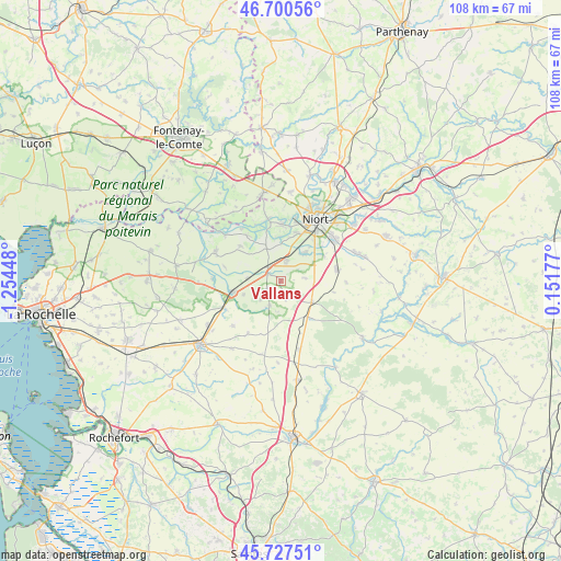
Vallans GPS coordinates[2]
46° 12' 58.284" North, 0° 33' 4.86" West
| Map corner | latitude | longitude |
|---|---|---|
| Upper-left | 46.70056°, | -1.25448° |
| Center: | 46.21619°, | -0.55135° |
| Lower-right: | 45.72751°, | 0.15177° |
| Map W x H: | 108.2×108.2 km | = 67.2×67.2mi |
| max Lat: | 51.07786° ⇑63.3% North |
| Vallans: | 46.21619° |
| min Lat: | ⇓36.7% South 41.3874° |
| min Long | Vallans | max Long |
| -5.08615° | -0.55135° | 9.52242° |
| W 16%⇐ | ⇒84% E |
Elevation
Elevation of Vallans is 33 m = 108 ft, and this is 160.7 m = 527 ft below average elevation for this country.
| Max E: |
2333 m = 7654 ft | 88.6% |
| Avg. | 193.7 m = 635 ft | |
| Vallans | 33 m = 108 ft | |
Min E: |
-1 m = -3 ft | 11.4% |
See also: France elevation on elevation.city.
Geographical zone
Vallans is located in North temperate zone (between Tropic of Cancer and the Arctic Circle). Distance of this North polar circle is 2262.4 km =1405.8 mi to North.| Distance of | km | miles | from Vallans |
|---|---|---|---|
| North Pole | 4868.3 | 3025 | to North |
| Arctic Circle | 2262.4 | 1405.8 | to North |
| Tropic Cancer | 2532.8 | 1573.8 | to South |
| Equator | 5138.8 | 3193.1 | to South |


Nearby cities:
15 places around Vallans: (largest is in red/bold)
• Beauvoir-sur-Niort
7.1 km =4.4 mi,  122°
122°
• Bessines
9.9 km =6.2 mi,  15°
15°
• Fors
11.1 km =6.9 mi,  78°
78°
• Frontenay-Rohan-Rohan
4.2 km =2.6 mi,  13°
13°
• Granzay-Gript
5.2 km =3.2 mi,  89°
89°
• La Foye-Monjault
3.5 km =2.2 mi,  163°
163°
• Magné
11 km =6.8 mi,  1°
1°
• Marigny
10.4 km =6.5 mi,  101°
101°
• Marsais
10.8 km =6.7 mi,  200°
200°
• Mauzé-sur-le-Mignon
9.3 km =5.8 mi,  255°
255°
• Prissé-la-Charrière
8.4 km =5.2 mi,  151°
151°
• Saint-Symphorien
7 km =4.3 mi,  40°
40°
• Sansais
7 km =4.3 mi,  337°
337°
• Usseau
5.2 km =3.2 mi,  205°
205°
• Épannes
2.9 km =1.8 mi,  301°
301°
Sources, notices
• [Note1] Compared only with cities in France existing in our database
• [Src1] Map data: © OpenStreetMap contributors (CC-BY-SA)
• [Src2] Other city data from geonames.org with taken over terms of usage.
• [Src3] Geographical zone / Annual Mean Temperature by Robert A. Rohde @ Wikipedia
