Guengat geodata
Guengat (Brittany) is a populated place; located in France in Europe/Paris (GMT+2) time zone. With population of 1,686 people, there are 5559 cities with bigger population in this country. Compared to other cities in France, 60.1% of cities are located further ↓South; 99.3% of cities are located further →East and 56.9% of cities have higher elevation than Guengat. Note1
Administrative division(s):
- Level 1: Brittany
- Level 2: Département du Finistère
- Level 3: Arrondissement de Quimper
- Level 4: Guengat


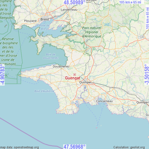
Guengat GPS coordinates[2]
48° 2' 30.948" North, 4° 12' 16.92" West
| Map corner | latitude | longitude |
|---|---|---|
| Upper-left | 48.50989°, | -4.90783° |
| Center: | 48.04193°, | -4.2047° |
| Lower-right: | 47.56968°, | -3.50158° |
| Map W x H: | 104.5×104.5 km | = 64.9×64.9mi |
| max Lat: | 51.07786° ⇑39.9% North |
| Guengat: | 48.04193° |
| min Lat: | ⇓60.1% South 41.3874° |
| min Long | Guengat | max Long |
| -5.08615° | -4.2047° | 9.52242° |
| W 0.7%⇐ | ⇒99.3% E |
Elevation
Elevation of Guengat is 111 m = 364 ft, and this is 82.7 m = 271 ft below average elevation for this country.
| Max E: |
2333 m = 7654 ft | 56.9% |
| Avg. | 193.7 m = 635 ft | |
| Guengat | 111 m = 364 ft | |
Min E: |
-1 m = -3 ft | 43.1% |
See also: France elevation on elevation.city.
Geographical zone
Guengat is located in North temperate zone (between Tropic of Cancer and the Arctic Circle). Distance of this North polar circle is 2059.4 km =1279.7 mi to North.| Distance of | km | miles | from Guengat |
|---|---|---|---|
| North Pole | 4665.3 | 2898.9 | to North |
| Arctic Circle | 2059.4 | 1279.7 | to North |
| Tropic Cancer | 2735.8 | 1699.9 | to South |
| Equator | 5341.8 | 3319.2 | to South |


Nearby cities:
15 places around Guengat: (largest is in red/bold)
• Douarnenez
11 km =6.8 mi,  302°
302°
• Gourlizon
5.2 km =3.2 mi,  240°
240°
• Kerlaz
7.4 km =4.6 mi,  317°
317°
• Landrévarzec
12.1 km =7.5 mi,  62°
62°
• Landudec
10.9 km =6.8 mi, 244°
• Le Juch
4.6 km =2.9 mi,  305°
305°
• Locronan
6.3 km =3.9 mi,  358°
358°
• Plogastel-Saint-Germain
8 km =5 mi,  215°
215°
• Plogonnec
4.9 km =3 mi,  19°
19°
• Plonéis
2.9 km =1.8 mi,  197°
197°
• Plonévez-Porzay
6.5 km =4 mi,  352°
352°
• Pluguffan
6.7 km =4.2 mi,  166°
166°
• Pouldergat
9.6 km =6 mi,  275°
275°
• Quimper
9.1 km =5.7 mi,  120°
120°
• Quéménéven
10.6 km =6.6 mi,  38°
38°
Sources, notices
• [Note1] Compared only with cities in France existing in our database
• [Src1] Map data: © OpenStreetMap contributors (CC-BY-SA)
• [Src2] Other city data from geonames.org with taken over terms of usage.
• [Src3] Geographical zone / Annual Mean Temperature by Robert A. Rohde @ Wikipedia
