Domène geodata
Domène (Auvergne-Rhône-Alpes) is a populated place; located in France in Europe/Paris (GMT+2) time zone. With population of 6,882 people, there are 1439 cities with bigger population in this country. Compared to other cities in France, 77.4% of cities are located further ↑North; 85.4% of cities are located further ←West and 73.3% of cities have lower elevation than Domène. Note1
Administrative division(s):
- Level 1: Auvergne-Rhône-Alpes
- Level 2: Département de l'Isère
- Level 3: Arrondissement de Grenoble
- Level 4: Domène


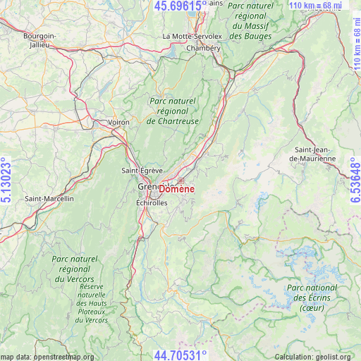
Domène GPS coordinates[2]
45° 12' 10.404" North, 5° 50' 0.06" East
| Map corner | latitude | longitude |
|---|---|---|
| Upper-left | 45.69615°, | 5.13023° |
| Center: | 45.20289°, | 5.83335° |
| Lower-right: | 44.70531°, | 6.53648° |
| Map W x H: | 110.2×110.2 km | = 68.5×68.5mi |
| max Lat: | 51.07786° ⇑77.4% North |
| Domène: | 45.20289° |
| min Lat: | ⇓22.6% South 41.3874° |
| min Long | Domène | max Long |
| -5.08615° | 5.83335° | 9.52242° |
| W 85.4%⇐ | ⇒14.6% E |
Elevation
Elevation of Domène is 238 m = 781 ft, and this is 44.3 m = 145 ft above average elevation for this country.
| Max E: |
2333 m = 7654 ft | 26.7% |
| Domène | 238 m 781 ft | |
| Avg. | 193.7 m = 635 ft | |
Min E: |
-1 m = -3 ft | 73.3% |
See also: France elevation on elevation.city.
Geographical zone
Domène is located in North temperate zone (between Tropic of Cancer and the Arctic Circle). Distance of this North polar circle is 2375.1 km =1475.8 mi to North.| Distance of | km | miles | from Domène |
|---|---|---|---|
| North Pole | 4981 | 3095 | to North |
| Arctic Circle | 2375.1 | 1475.8 | to North |
| Tropic Cancer | 2420.2 | 1503.8 | to South |
| Equator | 5026.1 | 3123.1 | to South |


Nearby cities:
15 places around Domène: (largest is in red/bold)
• Biviers
4.3 km =2.7 mi,  322°
322°
• Corenc
5.6 km =3.5 mi,  288°
288°
• Gières
4.3 km =2.7 mi,  233°
233°
• La Combe-de-Lancey
5.5 km =3.4 mi,  64°
64°
• La Tronche
6.8 km =4.2 mi,  272°
272°
• Le Versoud
3.1 km =1.9 mi,  52°
52°
• Meylan
4.4 km =2.7 mi,  279°
279°
• Montbonnot-Saint-Martin
3.5 km =2.2 mi, 315°
• Murianette
1.8 km =1.1 mi,  221°
221°
• Revel
3.6 km =2.2 mi,  121°
121°
• Saint-Ismier
5.5 km =3.4 mi,  357°
357°
• Saint-Martin-d’Hères
6.1 km =3.8 mi,  244°
244°
• Saint-Nazaire-les-Eymes
5.4 km =3.4 mi,  16°
16°
• Venon
3.6 km =2.2 mi,  213°
213°
• Villard-Bonnot
5.3 km =3.3 mi, 47°
Sources, notices
• [Note1] Compared only with cities in France existing in our database
• [Src1] Map data: © OpenStreetMap contributors (CC-BY-SA)
• [Src2] Other city data from geonames.org with taken over terms of usage.
• [Src3] Geographical zone / Annual Mean Temperature by Robert A. Rohde @ Wikipedia
