Corenc geodata
Corenc (Auvergne-Rhône-Alpes) is a populated place; located in France in Europe/Paris (GMT+2) time zone. With population of 4,217 people, there are 2333 cities with bigger population in this country. Compared to other cities in France, 77.2% of cities are located further ↑North; 84.8% of cities are located further ←West and 88.7% of cities have lower elevation than Corenc. Note1
Administrative division(s):
- Level 1: Auvergne-Rhône-Alpes
- Level 2: Département de l'Isère
- Level 3: Arrondissement de Grenoble
- Level 4: Corenc


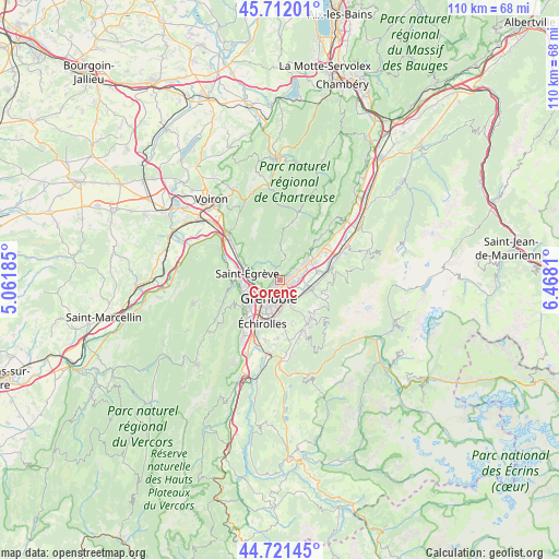
Corenc GPS coordinates[2]
45° 13' 8.004" North, 5° 45' 53.892" East
| Map corner | latitude | longitude |
|---|---|---|
| Upper-left | 45.71201°, | 5.06185° |
| Center: | 45.21889°, | 5.76497° |
| Lower-right: | 44.72145°, | 6.4681° |
| Map W x H: | 110.1×110.1 km | = 68.4×68.4mi |
| max Lat: | 51.07786° ⇑77.2% North |
| Corenc: | 45.21889° |
| min Lat: | ⇓22.8% South 41.3874° |
| min Long | Corenc | max Long |
| -5.08615° | 5.76497° | 9.52242° |
| W 84.8%⇐ | ⇒15.2% E |
Elevation
Elevation of Corenc is 401 m = 1316 ft, and this is 207.3 m = 680 ft above average elevation for this country.
| Max E: |
2333 m = 7654 ft | 11.3% |
| Corenc | 401 m 1316 ft | |
| Avg. | 193.7 m = 635 ft | |
Min E: |
-1 m = -3 ft | 88.7% |
See also: France elevation on elevation.city.
Geographical zone
Corenc is located in North temperate zone (between Tropic of Cancer and the Arctic Circle). Distance of this North polar circle is 2373.3 km =1474.7 mi to North.| Distance of | km | miles | from Corenc |
|---|---|---|---|
| North Pole | 4979.2 | 3093.9 | to North |
| Arctic Circle | 2373.3 | 1474.7 | to North |
| Tropic Cancer | 2422 | 1505 | to South |
| Equator | 5027.9 | 3124.2 | to South |


Nearby cities:
15 places around Corenc: (largest is in red/bold)
• Biviers
3.2 km =2 mi,  59°
59°
• Domène
5.6 km =3.5 mi,  108°
108°
• Gières
4.7 km =2.9 mi,  156°
156°
• Grenoble
6 km =3.7 mi,  221°
221°
• La Tronche
2.1 km =1.3 mi, 223°
• Le Sappey-en-Chartreuse
4.9 km =3 mi,  9°
9°
• Meylan
1.4 km =0.9 mi,  135°
135°
• Montbonnot-Saint-Martin
3 km =1.9 mi,  75°
75°
• Murianette
5.2 km =3.2 mi,  126°
126°
• Poisat
6.7 km =4.2 mi,  182°
182°
• Quaix-en-Chartreuse
5.1 km =3.2 mi,  312°
312°
• Saint-Ismier
6.3 km =3.9 mi,  54°
54°
• Saint-Martin-d’Hères
4.5 km =2.8 mi, 182°
• Saint-Martin-le-Vinoux
4.2 km =2.6 mi,  245°
245°
• Venon
5.8 km =3.6 mi, 144°
Sources, notices
• [Note1] Compared only with cities in France existing in our database
• [Src1] Map data: © OpenStreetMap contributors (CC-BY-SA)
• [Src2] Other city data from geonames.org with taken over terms of usage.
• [Src3] Geographical zone / Annual Mean Temperature by Robert A. Rohde @ Wikipedia
