Doix geodata
Doix (Pays de la Loire) is a populated place; located in France in Europe/Paris (GMT+2) time zone. With population of 843 people, there are 10148 cities with bigger population in this country. Compared to other cities in France, 61.2% of cities are located further ↑North; 86.5% of cities are located further →East and 97.4% of cities have higher elevation than Doix. Note1
Administrative division(s):
- Level 1: Pays de la Loire
- Level 2: Département de la Vendée
- Level 3: Arrondissement de Fontenay-le-Comte
- Level 4: Doix lès Fontaines


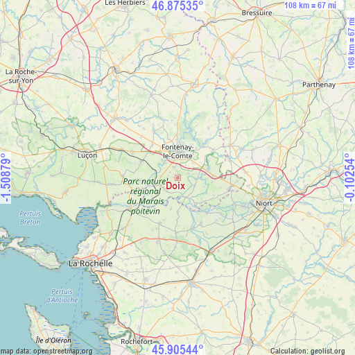
Doix GPS coordinates[2]
46° 23' 33.18" North, 0° 48' 20.412" West
| Map corner | latitude | longitude |
|---|---|---|
| Upper-left | 46.87535°, | -1.50879° |
| Center: | 46.39255°, | -0.80567° |
| Lower-right: | 45.90544°, | -0.10254° |
| Map W x H: | 107.8×107.8 km | = 67×67mi |
| max Lat: | 51.07786° ⇑61.2% North |
| Doix: | 46.39255° |
| min Lat: | ⇓38.8% South 41.3874° |
| min Long | Doix | max Long |
| -5.08615° | -0.80567° | 9.52242° |
| W 13.5%⇐ | ⇒86.5% E |
Elevation
Elevation of Doix is 10 m = 33 ft, and this is 183.7 m = 603 ft below average elevation for this country.
| Max E: |
2333 m = 7654 ft | 97.4% |
| Avg. | 193.7 m = 635 ft | |
| Doix | 10 m = 33 ft | |
Min E: |
-1 m = -3 ft | 2.6% |
See also: France elevation on elevation.city.
Geographical zone
Doix is located in North temperate zone (between Tropic of Cancer and the Arctic Circle). Distance of this North polar circle is 2242.8 km =1393.6 mi to North.| Distance of | km | miles | from Doix |
|---|---|---|---|
| North Pole | 4848.7 | 3012.8 | to North |
| Arctic Circle | 2242.8 | 1393.6 | to North |
| Tropic Cancer | 2552.4 | 1586 | to South |
| Equator | 5158.4 | 3205.3 | to South |


Nearby cities:
15 places around Doix: (largest is in red/bold)
• Auzay
7.1 km =4.4 mi,  323°
323°
• Damvix
10.2 km =6.3 mi,  147°
147°
• Fontaines
3.8 km =2.4 mi,  339°
339°
• Fontenay-le-Comte
8.3 km =5.2 mi,  359°
359°
• La Ronde
10.4 km =6.5 mi,  180°
180°
• Le Gué-de-Velluire
8.5 km =5.3 mi,  254°
254°
• Le Poiré-sur-Velluire
7.3 km =4.5 mi,  287°
287°
• Maillezais
5.5 km =3.4 mi,  113°
113°
• Maillé
5.8 km =3.6 mi,  166°
166°
• Montreuil
3 km =1.9 mi,  305°
305°
• Saint-Martin-de-Fraigneau
6.6 km =4.1 mi,  43°
43°
• Saint-Pierre-le-Vieux
4.4 km =2.7 mi,  98°
98°
• Taugon
9.6 km =6 mi,  193°
193°
• Velluire
6.9 km =4.3 mi,  281°
281°
• Vix
5.2 km =3.2 mi,  233°
233°
Sources, notices
• [Note1] Compared only with cities in France existing in our database
• [Src1] Map data: © OpenStreetMap contributors (CC-BY-SA)
• [Src2] Other city data from geonames.org with taken over terms of usage.
• [Src3] Geographical zone / Annual Mean Temperature by Robert A. Rohde @ Wikipedia
