Fontenay-le-Comte geodata
Fontenay-le-Comte (Pays de la Loire) is a seat of a third-order administrative division; located in France in Europe/Paris (GMT+2) time zone. With population of 16,316 people, there are 580 cities with bigger population in this country. Compared to other cities in France, 60.4% of cities are located further ↑North; 86.5% of cities are located further →East and 97.8% of cities have higher elevation than Fontenay-le-Comte. Note1
Administrative division(s):
- Level 1: Pays de la Loire
- Level 2: Département de la Vendée
- Level 3: Arrondissement de Fontenay-le-Comte
- Level 4: Fontenay-le-Comte


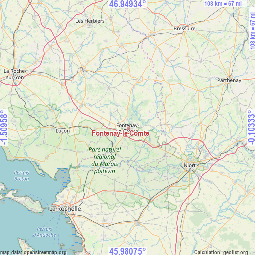
Fontenay-le-Comte GPS coordinates[2]
46° 28' 1.92" North, 0° 48' 23.22" West
| Map corner | latitude | longitude |
|---|---|---|
| Upper-left | 46.94934°, | -1.50958° |
| Center: | 46.4672°, | -0.80645° |
| Lower-right: | 45.98075°, | -0.10333° |
| Map W x H: | 107.7×107.7 km | = 66.9×66.9mi |
| max Lat: | 51.07786° ⇑60.4% North |
| Fontenay-le-Comte: | 46.4672° |
| min Lat: | ⇓39.6% South 41.3874° |
| min Long | Fontenay-le-Com | max Long |
| -5.08615° | -0.80645° | 9.52242° |
| W 13.5%⇐ | ⇒86.5% E |
Elevation
Elevation of Fontenay-le-Comte is 9 m = 30 ft, and this is 184.7 m = 606 ft below average elevation for this country.
| Max E: |
2333 m = 7654 ft | 97.8% |
| Avg. | 193.7 m = 635 ft | |
| Fontenay-le-Comte | 9 m = 30 ft | |
Min E: |
-1 m = -3 ft | 2.2% |
See also: France elevation on elevation.city.
Geographical zone
Fontenay-le-Comte is located in North temperate zone (between Tropic of Cancer and the Arctic Circle). Distance of this North polar circle is 2234.5 km =1388.5 mi to North.| Distance of | km | miles | from Fontenay-le-Comte |
|---|---|---|---|
| North Pole | 4840.4 | 3007.7 | to North |
| Arctic Circle | 2234.5 | 1388.5 | to North |
| Tropic Cancer | 2560.7 | 1591.1 | to South |
| Equator | 5166.7 | 3210.4 | to South |


Nearby cities:
15 places around Fontenay-le-Comte: (largest is in red/bold)
• Auzay
4.9 km =3 mi,  237°
237°
• Bourneau
8 km =5 mi,  353°
353°
• Doix
8.3 km =5.2 mi,  179°
179°
• Fontaines
4.9 km =3 mi,  194°
194°
• Le Poiré-sur-Velluire
9.2 km =5.7 mi,  228°
228°
• Marsais-Sainte-Radégonde
9.6 km =6 mi,  324°
324°
• Mervent
7.2 km =4.5 mi,  31°
31°
• Montreuil
7 km =4.3 mi,  199°
199°
• Petosse
8.6 km =5.3 mi,  281°
281°
• Pissotte
3.3 km =2.1 mi,  359°
359°
• Saint-Martin-de-Fraigneau
5.8 km =3.6 mi,  126°
126°
• Saint-Michel-le-Cloucq
4.6 km =2.9 mi,  64°
64°
• Sérigné
4.8 km =3 mi, 322°
• Velluire
9.7 km =6 mi,  223°
223°
• Xanton-Chassenon
8.7 km =5.4 mi,  100°
100°
Sources, notices
• [Note1] Compared only with cities in France existing in our database
• [Src1] Map data: © OpenStreetMap contributors (CC-BY-SA)
• [Src2] Other city data from geonames.org with taken over terms of usage.
• [Src3] Geographical zone / Annual Mean Temperature by Robert A. Rohde @ Wikipedia
