Saint-Rémy-du-Plain geodata
Saint-Rémy-du-Plain (Brittany) is a populated place; located in France in Europe/Paris (GMT+2) time zone. With population of 631 people, there are 12802 cities with bigger population in this country. Compared to other cities in France, 65.8% of cities are located further ↓South; 92.7% of cities are located further →East and 64.4% of cities have higher elevation than Saint-Rémy-du-Plain. Note1
Administrative division(s):
- Level 1: Brittany
- Level 2: Département d'Ille-et-Vilaine
- Level 3: Arrondissement de Fougères-Vitré
- Level 4: Saint-Rémy-du-Plain


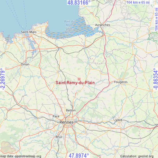
Saint-Rémy-du-Plain GPS coordinates[2]
48° 22' 0.012" North, 1° 34' 0.012" West
| Map corner | latitude | longitude |
|---|---|---|
| Upper-left | 48.83166°, | -2.26979° |
| Center: | 48.36667°, | -1.56667° |
| Lower-right: | 47.8974°, | -0.86354° |
| Map W x H: | 103.9×103.9 km | = 64.6×64.6mi |
| max Lat: | 51.07786° ⇑34.2% North |
| Saint-Rémy-du-Plain: | 48.36667° |
| min Lat: | ⇓65.8% South 41.3874° |
| min Long | Saint-Rémy-du- | max Long |
| -5.08615° | -1.56667° | 9.52242° |
| W 7.3%⇐ | ⇒92.7% E |
Elevation
Elevation of Saint-Rémy-du-Plain is 91 m = 299 ft, and this is 102.7 m = 337 ft below average elevation for this country.
| Max E: |
2333 m = 7654 ft | 64.4% |
| Avg. | 193.7 m = 635 ft | |
| Saint-Rémy-du-Plain | 91 m = 299 ft | |
Min E: |
-1 m = -3 ft | 35.6% |
See also: France elevation on elevation.city.
Geographical zone
Saint-Rémy-du-Plain is located in North temperate zone (between Tropic of Cancer and the Arctic Circle). Distance of this North polar circle is 2023.3 km =1257.2 mi to North.| Distance of | km | miles | from Saint-Rémy-du-Plain |
|---|---|---|---|
| North Pole | 4629.2 | 2876.5 | to North |
| Arctic Circle | 2023.3 | 1257.2 | to North |
| Tropic Cancer | 2772 | 1722.4 | to South |
| Equator | 5377.9 | 3341.7 | to South |


Nearby cities:
15 places around Saint-Rémy-du-Plain: (largest is in red/bold)
• Andouillé-Neuville
8.4 km =5.2 mi,  191°
191°
• Antrain
12.1 km =7.5 mi,  30°
30°
• Bazouges-la-Pérouse
6.6 km =4.1 mi,  355°
355°
• Chauvigné
7.9 km =4.9 mi,  82°
82°
• Dingé
11 km =6.8 mi,  264°
264°
• Feins
6.9 km =4.3 mi,  232°
232°
• Gahard
8.4 km =5.2 mi,  155°
155°
• La Fontenelle
12.1 km =7.5 mi,  22°
22°
• Marcillé-Raoul
3.5 km =2.2 mi,  304°
304°
• Montreuil-sur-Ille
10 km =6.2 mi, 229°
• Saint-Marc-le-Blanc
11.6 km =7.2 mi,  90°
90°
• Saint-Ouen-des-Alleux
11.3 km =7 mi,  112°
112°
• Sens-de-Bretagne
4.5 km =2.8 mi,  148°
148°
• Tremblay
9.1 km =5.7 mi,  47°
47°
• Vieux-Vy-sur-Couesnon
6.4 km =4 mi,  115°
115°
Sources, notices
• [Note1] Compared only with cities in France existing in our database
• [Src1] Map data: © OpenStreetMap contributors (CC-BY-SA)
• [Src2] Other city data from geonames.org with taken over terms of usage.
• [Src3] Geographical zone / Annual Mean Temperature by Robert A. Rohde @ Wikipedia
