Dinéault geodata
Dinéault (Brittany) is a populated place; located in France in Europe/Paris (GMT+2) time zone. With population of 1,974 people, there are 4844 cities with bigger population in this country. Compared to other cities in France, 63.1% of cities are located further ↓South; 99.2% of cities are located further →East and 59.7% of cities have higher elevation than Dinéault. Note1
Administrative division(s):
- Level 1: Brittany
- Level 2: Département du Finistère
- Level 3: Arrondissement de Châteaulin
- Level 4: Dinéault


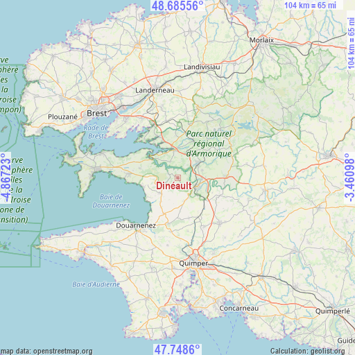
Dinéault GPS coordinates[2]
48° 13' 9.192" North, 4° 9' 50.796" West
| Map corner | latitude | longitude |
|---|---|---|
| Upper-left | 48.68556°, | -4.86723° |
| Center: | 48.21922°, | -4.16411° |
| Lower-right: | 47.7486°, | -3.46098° |
| Map W x H: | 104.2×104.2 km | = 64.7×64.7mi |
| max Lat: | 51.07786° ⇑36.9% North |
| Dinéault: | 48.21922° |
| min Lat: | ⇓63.1% South 41.3874° |
| min Long | Dinéault | max Long |
| -5.08615° | -4.16411° | 9.52242° |
| W 0.8%⇐ | ⇒99.2% E |
Elevation
Elevation of Dinéault is 103 m = 338 ft, and this is 90.7 m = 298 ft below average elevation for this country.
| Max E: |
2333 m = 7654 ft | 59.7% |
| Avg. | 193.7 m = 635 ft | |
| Dinéault | 103 m = 338 ft | |
Min E: |
-1 m = -3 ft | 40.3% |
See also: France elevation on elevation.city.
Geographical zone
Dinéault is located in North temperate zone (between Tropic of Cancer and the Arctic Circle). Distance of this North polar circle is 2039.7 km =1267.4 mi to North.| Distance of | km | miles | from Dinéault |
|---|---|---|---|
| North Pole | 4645.6 | 2886.6 | to North |
| Arctic Circle | 2039.7 | 1267.4 | to North |
| Tropic Cancer | 2755.6 | 1712.2 | to South |
| Equator | 5361.5 | 3331.5 | to South |


Nearby cities:
15 places around Dinéault: (largest is in red/bold)
• Argol
11.7 km =7.3 mi,  284°
284°
• Cast
7.2 km =4.5 mi,  164°
164°
• Châteaulin
6 km =3.7 mi,  114°
114°
• Hanvec
12 km =7.5 mi,  1°
1°
• Hôpital-Camfrout
13.4 km =8.3 mi,  334°
334°
• Le Faou
8.5 km =5.3 mi,  352°
352°
• Locronan
13.8 km =8.6 mi,  193°
193°
• Lopérec
10.8 km =6.7 mi,  53°
53°
• Plomodiern
6.5 km =4 mi,  232°
232°
• Plonévez-Porzay
13.8 km =8.6 mi,  196°
196°
• Quéménéven
11.9 km =7.4 mi, 162°
• Rosnoën
5.9 km =3.7 mi, 333°
• Saint-Nic
9.1 km =5.7 mi,  256°
256°
• Saint-Ségal
7.4 km =4.6 mi,  77°
77°
• Telgruc-sur-Mer
13.9 km =8.6 mi, 276°
Sources, notices
• [Note1] Compared only with cities in France existing in our database
• [Src1] Map data: © OpenStreetMap contributors (CC-BY-SA)
• [Src2] Other city data from geonames.org with taken over terms of usage.
• [Src3] Geographical zone / Annual Mean Temperature by Robert A. Rohde @ Wikipedia
