Crotelles geodata
Crotelles (Centre) is a populated place; located in France in Europe/Paris (GMT+2) time zone. With population of 553 people, there are 14157 cities with bigger population in this country. Compared to other cities in France, 51.9% of cities are located further ↓South; 70.2% of cities are located further →East and 59.4% of cities have higher elevation than Crotelles. Note1
Administrative division(s):
- Level 1: Centre
- Level 2: Département d'Indre-et-Loire
- Level 3: Arrondissement de Loches
- Level 4: Crotelles


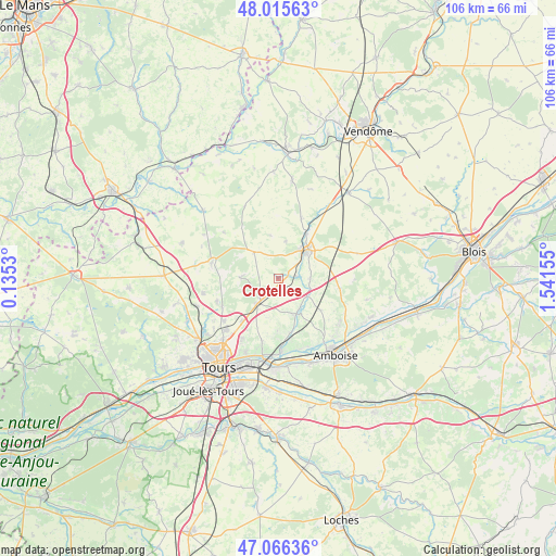
Crotelles GPS coordinates[2]
47° 32' 35.304" North, 0° 50' 18.312" East
| Map corner | latitude | longitude |
|---|---|---|
| Upper-left | 48.01563°, | 0.1353° |
| Center: | 47.54314°, | 0.83842° |
| Lower-right: | 47.06636°, | 1.54155° |
| Map W x H: | 105.5×105.5 km | = 65.6×65.6mi |
| max Lat: | 51.07786° ⇑48.1% North |
| Crotelles: | 47.54314° |
| min Lat: | ⇓51.9% South 41.3874° |
| min Long | Crotelles | max Long |
| -5.08615° | 0.83842° | 9.52242° |
| W 29.8%⇐ | ⇒70.2% E |
Elevation
Elevation of Crotelles is 104 m = 341 ft, and this is 89.7 m = 294 ft below average elevation for this country.
| Max E: |
2333 m = 7654 ft | 59.4% |
| Avg. | 193.7 m = 635 ft | |
| Crotelles | 104 m = 341 ft | |
Min E: |
-1 m = -3 ft | 40.6% |
See also: France elevation on elevation.city.
Geographical zone
Crotelles is located in North temperate zone (between Tropic of Cancer and the Arctic Circle). Distance of this North polar circle is 2114.9 km =1314.1 mi to North.| Distance of | km | miles | from Crotelles |
|---|---|---|---|
| North Pole | 4720.8 | 2933.4 | to North |
| Arctic Circle | 2114.9 | 1314.1 | to North |
| Tropic Cancer | 2680.4 | 1665.5 | to South |
| Equator | 5286.3 | 3284.8 | to South |


Nearby cities:
15 places around Crotelles: (largest is in red/bold)
• Authon
12.1 km =7.5 mi,  20°
20°
• Auzouer-en-Touraine
6.2 km =3.9 mi,  90°
90°
• Chançay
10.3 km =6.4 mi,  164°
164°
• Château-Renault
7.7 km =4.8 mi,  45°
45°
• Le Boulay
7.1 km =4.4 mi,  12°
12°
• Monnaie
5.9 km =3.7 mi,  218°
218°
• Monthodon
11.9 km =7.4 mi,  359°
359°
• Montreuil-en-Touraine
10.3 km =6.4 mi,  126°
126°
• Neuillé-le-Lierre
6.4 km =4 mi,  122°
122°
• Neuville-sur-Brenne
10.1 km =6.3 mi,  35°
35°
• Nouzilly
6.9 km =4.3 mi,  271°
271°
• Reugny
7.6 km =4.7 mi,  152°
152°
• Saint-Laurent-en-Gâtines
6.6 km =4.1 mi,  316°
316°
• Saunay
12 km =7.5 mi,  56°
56°
• Villedômer
3.7 km =2.3 mi,  84°
84°
Sources, notices
• [Note1] Compared only with cities in France existing in our database
• [Src1] Map data: © OpenStreetMap contributors (CC-BY-SA)
• [Src2] Other city data from geonames.org with taken over terms of usage.
• [Src3] Geographical zone / Annual Mean Temperature by Robert A. Rohde @ Wikipedia
