Saunay geodata
Saunay (Centre) is a populated place; located in France in Europe/Paris (GMT+2) time zone. With population of 534 people, there are 14532 cities with bigger population in this country. Compared to other cities in France, 52.7% of cities are located further ↓South; 69% of cities are located further →East and 55.9% of cities have higher elevation than Saunay. Note1
Administrative division(s):
- Level 1: Centre
- Level 2: Département d'Indre-et-Loire
- Level 3: Arrondissement de Loches
- Level 4: Saunay


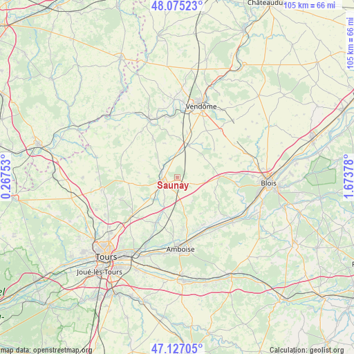
Saunay GPS coordinates[2]
47° 36' 11.844" North, 0° 58' 14.34" East
| Map corner | latitude | longitude |
|---|---|---|
| Upper-left | 48.07523°, | 0.26753° |
| Center: | 47.60329°, | 0.97065° |
| Lower-right: | 47.12705°, | 1.67378° |
| Map W x H: | 105.4×105.4 km | = 65.5×65.5mi |
| max Lat: | 51.07786° ⇑47.3% North |
| Saunay: | 47.60329° |
| min Lat: | ⇓52.7% South 41.3874° |
| min Long | Saunay | max Long |
| -5.08615° | 0.97065° | 9.52242° |
| W 31%⇐ | ⇒69% E |
Elevation
Elevation of Saunay is 114 m = 374 ft, and this is 79.7 m = 261 ft below average elevation for this country.
| Max E: |
2333 m = 7654 ft | 55.9% |
| Avg. | 193.7 m = 635 ft | |
| Saunay | 114 m = 374 ft | |
Min E: |
-1 m = -3 ft | 44.1% |
See also: France elevation on elevation.city.
Geographical zone
Saunay is located in North temperate zone (between Tropic of Cancer and the Arctic Circle). Distance of this North polar circle is 2108.2 km =1310 mi to North.| Distance of | km | miles | from Saunay |
|---|---|---|---|
| North Pole | 4714.1 | 2929.2 | to North |
| Arctic Circle | 2108.2 | 1310 | to North |
| Tropic Cancer | 2687.1 | 1669.7 | to South |
| Equator | 5293 | 3288.9 | to South |


Nearby cities:
15 places around Saunay: (largest is in red/bold)
• Authon
7.3 km =4.5 mi,  309°
309°
• Auzouer-en-Touraine
7.7 km =4.8 mi,  208°
208°
• Château-Renault
4.6 km =2.9 mi,  254°
254°
• Crotelles
12 km =7.5 mi,  236°
236°
• Herbault
12.6 km =7.8 mi,  89°
89°
• Le Boulay
8.4 km =5.2 mi,  271°
271°
• Monthodon
11.3 km =7 mi,  297°
297°
• Montreuil-en-Touraine
12.9 km =8 mi,  187°
187°
• Neuillé-le-Lierre
11.1 km =6.9 mi,  203°
203°
• Neuville-sur-Brenne
4.3 km =2.7 mi,  290°
290°
• Prunay-Cassereau
10.9 km =6.8 mi,  339°
339°
• Reugny
14.9 km =9.3 mi, 205°
• Saint-Amand-Longpré
9.5 km =5.9 mi,  21°
21°
• Saint-Laurent-en-Gâtines
14.6 km =9.1 mi,  262°
262°
• Villedômer
8.9 km =5.5 mi,  224°
224°
Sources, notices
• [Note1] Compared only with cities in France existing in our database
• [Src1] Map data: © OpenStreetMap contributors (CC-BY-SA)
• [Src2] Other city data from geonames.org with taken over terms of usage.
• [Src3] Geographical zone / Annual Mean Temperature by Robert A. Rohde @ Wikipedia
