Reugny geodata
Reugny (Centre) is a populated place; located in France in Europe/Paris (GMT+2) time zone. With population of 1,486 people, there are 6241 cities with bigger population in this country. Compared to other cities in France, 50.9% of cities are located further ↓South; 69.9% of cities are located further →East and 74.6% of cities have higher elevation than Reugny. Note1
Administrative division(s):
- Level 1: Centre
- Level 2: Département d'Indre-et-Loire
- Level 3: Arrondissement de Tours
- Level 4: Reugny


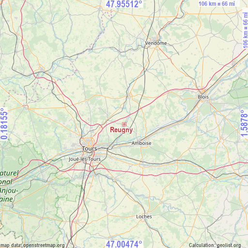
Reugny GPS coordinates[2]
47° 28' 55.488" North, 0° 53' 4.848" East
| Map corner | latitude | longitude |
|---|---|---|
| Upper-left | 47.95512°, | 0.18155° |
| Center: | 47.48208°, | 0.88468° |
| Lower-right: | 47.00474°, | 1.5878° |
| Map W x H: | 105.7×105.7 km | = 65.7×65.7mi |
| max Lat: | 51.07786° ⇑49.1% North |
| Reugny: | 47.48208° |
| min Lat: | ⇓50.9% South 41.3874° |
| min Long | Reugny | max Long |
| -5.08615° | 0.88468° | 9.52242° |
| W 30.1%⇐ | ⇒69.9% E |
Elevation
Elevation of Reugny is 68 m = 223 ft, and this is 125.7 m = 412 ft below average elevation for this country.
| Max E: |
2333 m = 7654 ft | 74.6% |
| Avg. | 193.7 m = 635 ft | |
| Reugny | 68 m = 223 ft | |
Min E: |
-1 m = -3 ft | 25.4% |
See also: France elevation on elevation.city.
Geographical zone
Reugny is located in North temperate zone (between Tropic of Cancer and the Arctic Circle). Distance of this North polar circle is 2121.7 km =1318.4 mi to North.| Distance of | km | miles | from Reugny |
|---|---|---|---|
| North Pole | 4727.5 | 2937.5 | to North |
| Arctic Circle | 2121.7 | 1318.4 | to North |
| Tropic Cancer | 2673.6 | 1661.3 | to South |
| Equator | 5279.5 | 3280.5 | to South |


Nearby cities:
15 places around Reugny: (largest is in red/bold)
• Amboise
10.7 km =6.6 mi,  136°
136°
• Auzouer-en-Touraine
7.2 km =4.5 mi,  21°
21°
• Chançay
3.2 km =2 mi,  193°
193°
• Crotelles
7.6 km =4.7 mi,  332°
332°
• Lussault-sur-Loire
10 km =6.2 mi,  166°
166°
• Monnaie
7.5 km =4.7 mi,  286°
286°
• Montreuil-en-Touraine
4.9 km =3 mi,  82°
82°
• Nazelles-Négron
7.3 km =4.5 mi, 137°
• Neuillé-le-Lierre
3.8 km =2.4 mi,  30°
30°
• Noizay
6.7 km =4.2 mi,  175°
175°
• Pocé-sur-Cisse
9.1 km =5.7 mi,  118°
118°
• Saint-Ouen-les-Vignes
8.4 km =5.2 mi,  101°
101°
• Vernou-sur-Brenne
7.5 km =4.7 mi,  201°
201°
• Villedômer
7.2 km =4.5 mi,  1°
1°
• Vouvray
10.2 km =6.3 mi,  219°
219°
Sources, notices
• [Note1] Compared only with cities in France existing in our database
• [Src1] Map data: © OpenStreetMap contributors (CC-BY-SA)
• [Src2] Other city data from geonames.org with taken over terms of usage.
• [Src3] Geographical zone / Annual Mean Temperature by Robert A. Rohde @ Wikipedia
