Crosville-la-Vieille geodata
Crosville-la-Vieille (Normandy) is a populated place; located in France in Europe/Paris (GMT+2) time zone. With population of 511 people, there are 15016 cities with bigger population in this country. Compared to other cities in France, 83.4% of cities are located further ↓South; 69.4% of cities are located further →East and 55% of cities have lower elevation than Crosville-la-Vieille. Note1
Administrative division(s):
- Level 1: Normandy
- Level 2: Département de l'Eure
- Level 3: Arrondissement de Bernay
- Level 4: Crosville-la-Vieille


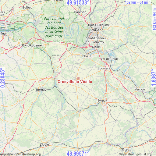
Crosville-la-Vieille GPS coordinates[2]
49° 9' 27.648" North, 0° 56' 0.852" East
| Map corner | latitude | longitude |
|---|---|---|
| Upper-left | 49.61538°, | 0.23045° |
| Center: | 49.15768°, | 0.93357° |
| Lower-right: | 48.69571°, | 1.6367° |
| Map W x H: | 102.3×102.3 km | = 63.6×63.6mi |
| max Lat: | 51.07786° ⇑16.6% North |
| Crosville-la-Vieille: | 49.15768° |
| min Lat: | ⇓83.4% South 41.3874° |
| min Long | Crosville-la-Vi | max Long |
| -5.08615° | 0.93357° | 9.52242° |
| W 30.6%⇐ | ⇒69.4% E |
Elevation
Elevation of Crosville-la-Vieille is 150 m = 492 ft, and this is 43.7 m = 143 ft below average elevation for this country.
| Max E: |
2333 m = 7654 ft | 45% |
| Avg. | 193.7 m = 635 ft | |
| Crosville-la-Vieille | 150 m = 492 ft | |
Min E: |
-1 m = -3 ft | 55% |
See also: France elevation on elevation.city.
Geographical zone
Crosville-la-Vieille is located in North temperate zone (between Tropic of Cancer and the Arctic Circle). Distance of this North polar circle is 1935.4 km =1202.6 mi to North.| Distance of | km | miles | from Crosville-la-Vieille |
|---|---|---|---|
| North Pole | 4541.2 | 2821.8 | to North |
| Arctic Circle | 1935.4 | 1202.6 | to North |
| Tropic Cancer | 2859.9 | 1777.1 | to South |
| Equator | 5465.8 | 3396.3 | to South |


Nearby cities:
15 places around Crosville-la-Vieille: (largest is in red/bold)
• Amfreville-la-Campagne
6.1 km =3.8 mi,  358°
358°
• Barc
12.8 km =8 mi,  219°
219°
• Canappeville
12.1 km =7.5 mi,  90°
90°
• Combon
7.5 km =4.7 mi,  204°
204°
• Harcourt
10.9 km =6.8 mi,  275°
275°
• La Haye-Malherbe
12.3 km =7.6 mi,  52°
52°
• La Saussaye
11.8 km =7.3 mi,  16°
16°
• Le Gros-Theil
10.1 km =6.3 mi,  318°
318°
• Le Neubourg
1.9 km =1.2 mi,  244°
244°
• Le Thuit-Signol
11.9 km =7.4 mi,  1°
1°
• Quittebeuf
8 km =5 mi,  131°
131°
• Saint-Didier-des-Bois
11.4 km =7.1 mi,  38°
38°
• Saint-Pierre-des-Fleurs
10.5 km =6.5 mi,  13°
13°
• Saint-Pierre-du-Bosguérard
12.3 km =7.6 mi,  342°
342°
• Tourville-la-Campagne
7.9 km =4.9 mi, 343°
Sources, notices
• [Note1] Compared only with cities in France existing in our database
• [Src1] Map data: © OpenStreetMap contributors (CC-BY-SA)
• [Src2] Other city data from geonames.org with taken over terms of usage.
• [Src3] Geographical zone / Annual Mean Temperature by Robert A. Rohde @ Wikipedia
