Barc geodata
Barc (Normandy) is a populated place; located in France in Europe/Paris (GMT+2) time zone. With population of 811 people, there are 10468 cities with bigger population in this country. Compared to other cities in France, 81.3% of cities are located further ↓South; 70.3% of cities are located further →East and 56.1% of cities have lower elevation than Barc. Note1
Administrative division(s):
- Level 1: Normandy
- Level 2: Département de l'Eure
- Level 3: Arrondissement de Bernay
- Level 4: Barc


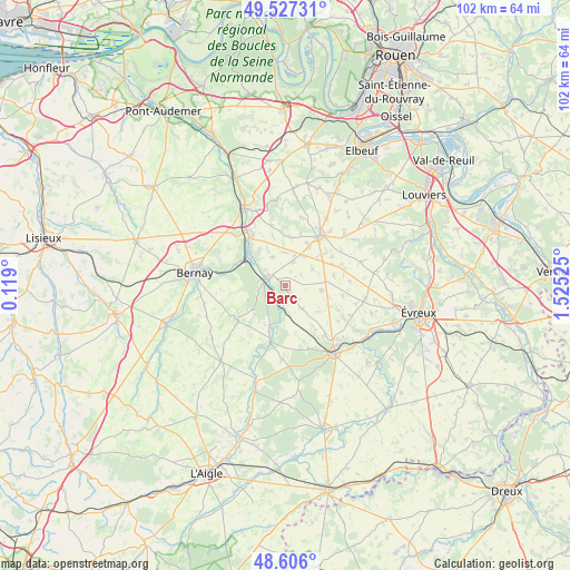
Barc GPS coordinates[2]
49° 4' 7.644" North, 0° 49' 19.632" East
| Map corner | latitude | longitude |
|---|---|---|
| Upper-left | 49.52731°, | 0.119° |
| Center: | 49.06879°, | 0.82212° |
| Lower-right: | 48.606°, | 1.52525° |
| Map W x H: | 102.4×102.4 km | = 63.6×63.6mi |
| max Lat: | 51.07786° ⇑18.7% North |
| Barc: | 49.06879° |
| min Lat: | ⇓81.3% South 41.3874° |
| min Long | Barc | max Long |
| -5.08615° | 0.82212° | 9.52242° |
| W 29.7%⇐ | ⇒70.3% E |
Elevation
Elevation of Barc is 154 m = 505 ft, and this is 39.7 m = 130 ft below average elevation for this country.
| Max E: |
2333 m = 7654 ft | 43.9% |
| Avg. | 193.7 m = 635 ft | |
| Barc | 154 m = 505 ft | |
Min E: |
-1 m = -3 ft | 56.1% |
See also: France elevation on elevation.city.
Geographical zone
Barc is located in North temperate zone (between Tropic of Cancer and the Arctic Circle). Distance of this North polar circle is 1945.2 km =1208.7 mi to North.| Distance of | km | miles | from Barc |
|---|---|---|---|
| North Pole | 4551.1 | 2827.9 | to North |
| Arctic Circle | 1945.2 | 1208.7 | to North |
| Tropic Cancer | 2850 | 1770.9 | to South |
| Equator | 5455.9 | 3390.1 | to South |


Nearby cities:
15 places around Barc: (largest is in red/bold)
• Beaumesnil
10.6 km =6.6 mi,  232°
232°
• Beaumont-le-Roger
3.2 km =2 mi,  289°
289°
• Beaumontel
4.6 km =2.9 mi, 289°
• Combon
5.9 km =3.7 mi,  58°
58°
• Crosville-la-Vieille
12.8 km =8 mi,  39°
39°
• Ferrières-Haut-Clocher
12.8 km =8 mi,  114°
114°
• Goupillières
7.9 km =4.9 mi,  325°
325°
• Grosley-sur-Risle
3 km =1.9 mi,  208°
208°
• Harcourt
11.3 km =7 mi,  346°
346°
• Le Fidelaire
13.3 km =8.3 mi,  182°
182°
• Le Neubourg
11.1 km =6.9 mi, 35°
• Louversey
11.4 km =7.1 mi,  140°
140°
• Nassandres
9 km =5.6 mi,  315°
315°
• Saint-Élier
13.9 km =8.6 mi,  131°
131°
• Serquigny
9.3 km =5.8 mi,  298°
298°
Sources, notices
• [Note1] Compared only with cities in France existing in our database
• [Src1] Map data: © OpenStreetMap contributors (CC-BY-SA)
• [Src2] Other city data from geonames.org with taken over terms of usage.
• [Src3] Geographical zone / Annual Mean Temperature by Robert A. Rohde @ Wikipedia
