Amfreville-la-Campagne geodata
Amfreville-la-Campagne (Normandy) is a populated place; located in France in Europe/Paris (GMT+2) time zone. With population of 913 people, there are 9550 cities with bigger population in this country. Compared to other cities in France, 84.5% of cities are located further ↓South; 69.4% of cities are located further →East and 57.6% of cities have lower elevation than Amfreville-la-Campagne. Note1
Administrative division(s):
- Level 1: Normandy
- Level 2: Département de l'Eure
- Level 3: Arrondissement de Bernay
- Level 4: Amfreville-Saint-Amand
Current local time in Amfreville-la-Campagne:
11:17 AM, SaturdayDifference from your time zone: hours


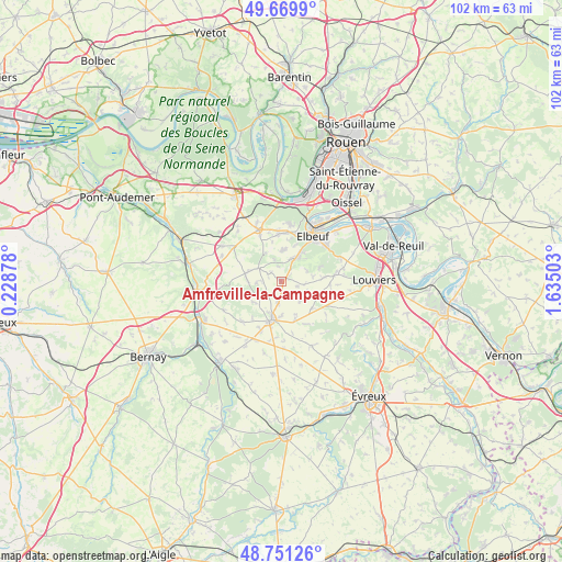
Amfreville-la-Campagne GPS coordinates[2]
49° 12' 45.756" North, 0° 55' 54.876" East
| Map corner | latitude | longitude |
|---|---|---|
| Upper-left | 49.6699°, | 0.22878° |
| Center: | 49.21271°, | 0.93191° |
| Lower-right: | 48.75126°, | 1.63503° |
| Map W x H: | 102.1×102.1 km | = 63.4×63.4mi |
| max Lat: | 51.07786° ⇑15.5% North |
| Amfreville-la-Campagne: | 49.21271° |
| min Lat: | ⇓84.5% South 41.3874° |
| min Long | Amfreville-la-C | max Long |
| -5.08615° | 0.93191° | 9.52242° |
| W 30.6%⇐ | ⇒69.4% E |
Elevation
Elevation of Amfreville-la-Campagne is 160 m = 525 ft, and this is 33.7 m = 111 ft below average elevation for this country.
| Max E: |
2333 m = 7654 ft | 42.4% |
| Avg. | 193.7 m = 635 ft | |
| Amfreville-la-Campagne | 160 m = 525 ft | |
Min E: |
-1 m = -3 ft | 57.6% |
See also: France elevation on elevation.city.
Geographical zone
Amfreville-la-Campagne is located in North temperate zone (between Tropic of Cancer and the Arctic Circle). Distance of this North polar circle is 1929.2 km =1198.7 mi to North.| Distance of | km | miles | from Amfreville-la-Campagne |
|---|---|---|---|
| North Pole | 4535.1 | 2818 | to North |
| Arctic Circle | 1929.2 | 1198.7 | to North |
| Tropic Cancer | 2866 | 1780.8 | to South |
| Equator | 5471.9 | 3400.1 | to South |


Nearby cities:
15 places around Amfreville-la-Campagne: (largest is in red/bold)
• Bosguérard-de-Marcouville
9.5 km =5.9 mi,  312°
312°
• Caudebec-lès-Elbeuf
10 km =6.2 mi,  40°
40°
• Crosville-la-Vieille
6.1 km =3.8 mi,  178°
178°
• Elbeuf
9.7 km =6 mi,  32°
32°
• La Saussaye
6.3 km =3.9 mi, 34°
• Le Bosc-Roger-en-Roumois
7.9 km =4.9 mi,  0°
0°
• Le Gros-Theil
6.7 km =4.2 mi,  283°
283°
• Le Neubourg
7.1 km =4.4 mi,  192°
192°
• Le Thuit-Anger
7.3 km =4.5 mi,  21°
21°
• Le Thuit-Signol
5.8 km =3.6 mi,  5°
5°
• Saint-Didier-des-Bois
7.8 km =4.8 mi,  68°
68°
• Saint-Ouen-du-Tilleul
9.5 km =5.9 mi, 6°
• Saint-Pierre-des-Fleurs
4.9 km =3 mi, 31°
• Saint-Pierre-du-Bosguérard
6.6 km =4.1 mi,  327°
327°
• Tourville-la-Campagne
2.6 km =1.6 mi, 305°
Sources, notices
• [Note1] Compared only with cities in France existing in our database
• [Src1] Map data: © OpenStreetMap contributors (CC-BY-SA)
• [Src2] Other city data from geonames.org with taken over terms of usage.
• [Src3] Geographical zone / Annual Mean Temperature by Robert A. Rohde @ Wikipedia
