Croix-Mare geodata
Croix-Mare (Normandy) is a populated place; located in France in Europe/Paris (GMT+2) time zone. With population of 603 people, there are 13268 cities with bigger population in this country. Compared to other cities in France, 90.5% of cities are located further ↓South; 70.1% of cities are located further →East and 55.3% of cities have lower elevation than Croix-Mare. Note1
Administrative division(s):
- Level 1: Normandy
- Level 2: Seine-Maritime
- Level 3: Arrondissement de Rouen
- Level 4: Croix-Mare


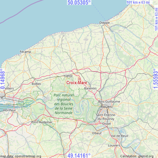
Croix-Mare GPS coordinates[2]
49° 35' 58.056" North, 0° 51' 10.08" East
| Map corner | latitude | longitude |
|---|---|---|
| Upper-left | 50.05305°, | 0.14968° |
| Center: | 49.59946°, | 0.8528° |
| Lower-right: | 49.14161°, | 1.55593° |
| Map W x H: | 101.3×101.3 km | = 62.9×62.9mi |
| max Lat: | 51.07786° ⇑9.5% North |
| Croix-Mare: | 49.59946° |
| min Lat: | ⇓90.5% South 41.3874° |
| min Long | Croix-Mare | max Long |
| -5.08615° | 0.8528° | 9.52242° |
| W 29.9%⇐ | ⇒70.1% E |
Elevation
Elevation of Croix-Mare is 151 m = 495 ft, and this is 42.7 m = 140 ft below average elevation for this country.
| Max E: |
2333 m = 7654 ft | 44.7% |
| Avg. | 193.7 m = 635 ft | |
| Croix-Mare | 151 m = 495 ft | |
Min E: |
-1 m = -3 ft | 55.3% |
See also: France elevation on elevation.city.
Geographical zone
Croix-Mare is located in North temperate zone (between Tropic of Cancer and the Arctic Circle). Distance of this North polar circle is 1886.2 km =1172 mi to North.| Distance of | km | miles | from Croix-Mare |
|---|---|---|---|
| North Pole | 4492.1 | 2791.3 | to North |
| Arctic Circle | 1886.2 | 1172 | to North |
| Tropic Cancer | 2909 | 1807.6 | to South |
| Equator | 5514.9 | 3426.8 | to South |


Nearby cities:
15 places around Croix-Mare: (largest is in red/bold)
• Blacqueville
4.3 km =2.7 mi,  166°
166°
• Bouville
5.2 km =3.2 mi,  143°
143°
• Criquetot-sur-Ouville
8.2 km =5.1 mi,  358°
358°
• Limésy
5.4 km =3.4 mi,  74°
74°
• Mesnil-Panneville
3 km =1.9 mi,  109°
109°
• Motteville
3.9 km =2.4 mi, 359°
• Pavilly
8.2 km =5.1 mi,  116°
116°
• Saint-Clair-sur-les-Monts
4.7 km =2.9 mi,  280°
280°
• Sainte-Marie-des-Champs
5.8 km =3.6 mi,  294°
294°
• Touffreville-la-Corbeline
6.7 km =4.2 mi,  253°
253°
• Villers-Écalles
8.1 km =5 mi, 143°
• Yerville
8.1 km =5 mi,  22°
22°
• Yvetot
7.1 km =4.4 mi, 286°
• Écalles-Alix
2.9 km =1.8 mi,  312°
312°
• Émanville
8.1 km =5 mi, 71°
Sources, notices
• [Note1] Compared only with cities in France existing in our database
• [Src1] Map data: © OpenStreetMap contributors (CC-BY-SA)
• [Src2] Other city data from geonames.org with taken over terms of usage.
• [Src3] Geographical zone / Annual Mean Temperature by Robert A. Rohde @ Wikipedia
