Criteuil-la-Magdeleine geodata
Criteuil-la-Magdeleine (Nouvelle-Aquitaine) is a populated place; located in France in Europe/Paris (GMT+2) time zone. With population of 533 people, there are 14546 cities with bigger population in this country. Compared to other cities in France, 73.7% of cities are located further ↑North; 79.9% of cities are located further →East and 78.2% of cities have higher elevation than Criteuil-la-Magdeleine. Note1
Administrative division(s):
- Level 1: Nouvelle-Aquitaine
- Level 2: Charente
- Level 3: Arrondissement de Cognac
- Level 4: Criteuil-la-Magdeleine
Current local time in Criteuil-la-Magdeleine:
07:07 PM, SaturdayDifference from your time zone: hours


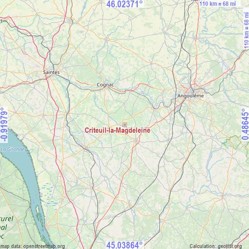
Criteuil-la-Magdeleine GPS coordinates[2]
45° 31' 59.988" North, 0° 13' 0.012" West
| Map corner | latitude | longitude |
|---|---|---|
| Upper-left | 46.02371°, | -0.91979° |
| Center: | 45.53333°, | -0.21667° |
| Lower-right: | 45.03864°, | 0.48645° |
| Map W x H: | 109.5×109.5 km | = 68×68mi |
| max Lat: | 51.07786° ⇑73.7% North |
| Criteuil-la-Magdeleine: | 45.53333° |
| min Lat: | ⇓26.3% South 41.3874° |
| min Long | Criteuil-la-Mag | max Long |
| -5.08615° | -0.21667° | 9.52242° |
| W 20.1%⇐ | ⇒79.9% E |
Elevation
Elevation of Criteuil-la-Magdeleine is 59 m = 194 ft, and this is 134.7 m = 442 ft below average elevation for this country.
| Max E: |
2333 m = 7654 ft | 78.2% |
| Avg. | 193.7 m = 635 ft | |
| Criteuil-la-Magdeleine | 59 m = 194 ft | |
Min E: |
-1 m = -3 ft | 21.8% |
See also: France elevation on elevation.city.
Geographical zone
Criteuil-la-Magdeleine is located in North temperate zone (between Tropic of Cancer and the Arctic Circle). Distance of this North polar circle is 2338.3 km =1453 mi to North.| Distance of | km | miles | from Criteuil-la-Magdeleine |
|---|---|---|---|
| North Pole | 4944.2 | 3072.2 | to North |
| Arctic Circle | 2338.3 | 1453 | to North |
| Tropic Cancer | 2456.9 | 1526.6 | to South |
| Equator | 5062.8 | 3145.9 | to South |


Nearby cities:
15 places around Criteuil-la-Magdeleine: (largest is in red/bold)
• Angeac-Champagne
9.9 km =6.2 mi,  318°
318°
• Archiac
6.8 km =4.2 mi,  254°
254°
• Barbezieux-Saint-Hilaire
8.4 km =5.2 mi,  143°
143°
• Barret
5.7 km =3.5 mi,  166°
166°
• Gensac-la-Pallue
13.2 km =8.2 mi,  348°
348°
• Genté
12.1 km =7.5 mi, 319°
• Germignac
9.8 km =6.1 mi,  292°
292°
• Guimps
7.9 km =4.9 mi,  199°
199°
• Juillac-le-Coq
6.8 km =4.2 mi,  325°
325°
• Lignières-Sonneville
4.5 km =2.8 mi,  35°
35°
• Mainxe
11.4 km =7.1 mi,  13°
13°
• Montchaude
9.4 km =5.8 mi, 172°
• Reignac
13.5 km =8.4 mi,  163°
163°
• Réaux
13.7 km =8.5 mi,  243°
243°
• Segonzac
9.3 km =5.8 mi,  0°
0°
Sources, notices
• [Note1] Compared only with cities in France existing in our database
• [Src1] Map data: © OpenStreetMap contributors (CC-BY-SA)
• [Src2] Other city data from geonames.org with taken over terms of usage.
• [Src3] Geographical zone / Annual Mean Temperature by Robert A. Rohde @ Wikipedia
