Archiac geodata
Archiac (Nouvelle-Aquitaine) is a populated place; located in France in Europe/Paris (GMT+2) time zone. With population of 817 people, there are 10416 cities with bigger population in this country. Compared to other cities in France, 73.9% of cities are located further ↑North; 80.9% of cities are located further →East and 65.6% of cities have higher elevation than Archiac. Note1
Administrative division(s):
- Level 1: Nouvelle-Aquitaine
- Level 2: Charente-Maritime
- Level 3: Arrondissement de Jonzac
- Level 4: Archiac


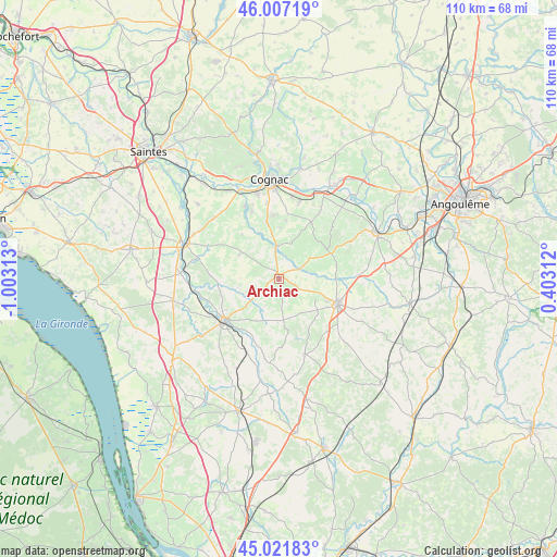
Archiac GPS coordinates[2]
45° 31' 0.012" North, 0° 18' 0" West
| Map corner | latitude | longitude |
|---|---|---|
| Upper-left | 46.00719°, | -1.00313° |
| Center: | 45.51667°, | -0.3° |
| Lower-right: | 45.02183°, | 0.40312° |
| Map W x H: | 109.6×109.6 km | = 68.1×68.1mi |
| max Lat: | 51.07786° ⇑73.9% North |
| Archiac: | 45.51667° |
| min Lat: | ⇓26.1% South 41.3874° |
| min Long | Archiac | max Long |
| -5.08615° | -0.3° | 9.52242° |
| W 19.1%⇐ | ⇒80.9% E |
Elevation
Elevation of Archiac is 88 m = 289 ft, and this is 105.7 m = 347 ft below average elevation for this country.
| Max E: |
2333 m = 7654 ft | 65.6% |
| Avg. | 193.7 m = 635 ft | |
| Archiac | 88 m = 289 ft | |
Min E: |
-1 m = -3 ft | 34.4% |
See also: France elevation on elevation.city.
Geographical zone
Archiac is located in North temperate zone (between Tropic of Cancer and the Arctic Circle). Distance of this North polar circle is 2340.2 km =1454.1 mi to North.| Distance of | km | miles | from Archiac |
|---|---|---|---|
| North Pole | 4946.1 | 3073.4 | to North |
| Arctic Circle | 2340.2 | 1454.1 | to North |
| Tropic Cancer | 2455.1 | 1525.5 | to South |
| Equator | 5061 | 3144.8 | to South |


Nearby cities:
15 places around Archiac: (largest is in red/bold)
• Angeac-Champagne
9.3 km =5.8 mi,  0°
0°
• Barbezieux-Saint-Hilaire
12.5 km =7.8 mi,  113°
113°
• Barret
8.6 km =5.3 mi,  115°
115°
• Champagnac
12.1 km =7.5 mi,  212°
212°
• Criteuil-la-Magdeleine
6.8 km =4.2 mi,  74°
74°
• Genté
11.2 km =7 mi,  353°
353°
• Germignac
6.1 km =3.8 mi,  334°
334°
• Guimps
6.8 km =4.2 mi,  144°
144°
• Jarnac-Champagne
9.2 km =5.7 mi,  301°
301°
• Juillac-le-Coq
7.9 km =4.9 mi,  19°
19°
• Lignières-Sonneville
10.7 km =6.6 mi,  58°
58°
• Montchaude
10.8 km =6.7 mi,  133°
133°
• Réaux
7.2 km =4.5 mi,  232°
232°
• Saint-Maigrin
11.2 km =7 mi,  173°
173°
• Segonzac
12.9 km =8 mi,  30°
30°
Sources, notices
• [Note1] Compared only with cities in France existing in our database
• [Src1] Map data: © OpenStreetMap contributors (CC-BY-SA)
• [Src2] Other city data from geonames.org with taken over terms of usage.
• [Src3] Geographical zone / Annual Mean Temperature by Robert A. Rohde @ Wikipedia
