Creully geodata
Creully (Normandy) is a populated place; located in France in Europe/Paris (GMT+2) time zone. With population of 1,490 people, there are 6229 cities with bigger population in this country. Compared to other cities in France, 85.8% of cities are located further ↓South; 83.8% of cities are located further →East and 90.7% of cities have higher elevation than Creully. Note1
Administrative division(s):
- Level 1: Normandy
- Level 2: Calvados
- Level 3: Arrondissement de Bayeux
- Level 4: Creully sur Seulles


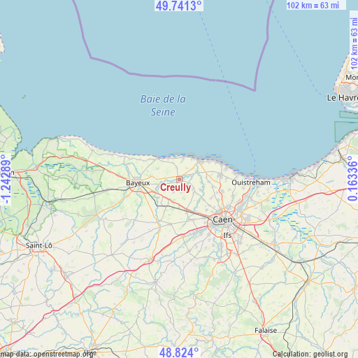
Creully GPS coordinates[2]
49° 17' 5.208" North, 0° 32' 23.136" West
| Map corner | latitude | longitude |
|---|---|---|
| Upper-left | 49.7413°, | -1.24289° |
| Center: | 49.28478°, | -0.53976° |
| Lower-right: | 48.824°, | 0.16336° |
| Map W x H: | 102×102 km | = 63.4×63.4mi |
| max Lat: | 51.07786° ⇑14.2% North |
| Creully: | 49.28478° |
| min Lat: | ⇓85.8% South 41.3874° |
| min Long | Creully | max Long |
| -5.08615° | -0.53976° | 9.52242° |
| W 16.2%⇐ | ⇒83.8% E |
Elevation
Elevation of Creully is 28 m = 92 ft, and this is 165.7 m = 544 ft below average elevation for this country.
| Max E: |
2333 m = 7654 ft | 90.7% |
| Avg. | 193.7 m = 635 ft | |
| Creully | 28 m = 92 ft | |
Min E: |
-1 m = -3 ft | 9.3% |
See also: France elevation on elevation.city.
Geographical zone
Creully is located in North temperate zone (between Tropic of Cancer and the Arctic Circle). Distance of this North polar circle is 1921.2 km =1193.8 mi to North.| Distance of | km | miles | from Creully |
|---|---|---|---|
| North Pole | 4527.1 | 2813 | to North |
| Arctic Circle | 1921.2 | 1193.8 | to North |
| Tropic Cancer | 2874 | 1785.8 | to South |
| Equator | 5480 | 3405.1 | to South |


Nearby cities:
15 places around Creully: (largest is in red/bold)
• Arromanches-les-Bains
8.6 km =5.3 mi,  313°
313°
• Asnelles
6.9 km =4.3 mi,  332°
332°
• Banville
5 km =3.1 mi,  51°
51°
• Basly
8.5 km =5.3 mi,  94°
94°
• Bretteville-l’Orgueilleuse
8.3 km =5.2 mi,  167°
167°
• Cairon
8.2 km =5.1 mi,  127°
127°
• Courseulles-sur-Mer
7.9 km =4.9 mi, 50°
• Fontaine-Henry
6.5 km =4 mi,  99°
99°
• Graye-sur-Mer
6.8 km =4.2 mi,  44°
44°
• Lantheuil
2.5 km =1.6 mi,  142°
142°
• Le Fresne-Camilly
4.7 km =2.9 mi, 126°
• Rosel
8.6 km =5.3 mi, 136°
• Sommervieu
7.8 km =4.8 mi,  276°
276°
• Thaon
6.8 km =4.2 mi,  116°
116°
• Ver-sur-Mer
5.1 km =3.2 mi,  7°
7°
Sources, notices
• [Note1] Compared only with cities in France existing in our database
• [Src1] Map data: © OpenStreetMap contributors (CC-BY-SA)
• [Src2] Other city data from geonames.org with taken over terms of usage.
• [Src3] Geographical zone / Annual Mean Temperature by Robert A. Rohde @ Wikipedia
