Sommervieu geodata
Sommervieu (Normandy) is a populated place; located in France in Europe/Paris (GMT+2) time zone. With population of 782 people, there are 10798 cities with bigger population in this country. Compared to other cities in France, 85.9% of cities are located further ↓South; 85% of cities are located further →East and 80.6% of cities have higher elevation than Sommervieu. Note1
Administrative division(s):
- Level 1: Normandy
- Level 2: Calvados
- Level 3: Arrondissement de Bayeux
- Level 4: Sommervieu


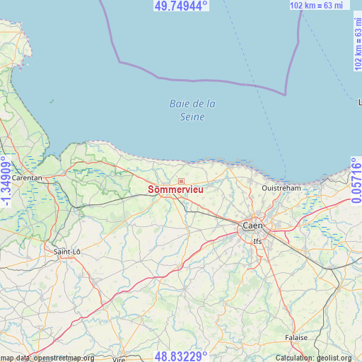
Sommervieu GPS coordinates[2]
49° 17' 34.8" North, 0° 38' 45.456" West
| Map corner | latitude | longitude |
|---|---|---|
| Upper-left | 49.74944°, | -1.34909° |
| Center: | 49.293°, | -0.64596° |
| Lower-right: | 48.83229°, | 0.05716° |
| Map W x H: | 102×102 km | = 63.4×63.4mi |
| max Lat: | 51.07786° ⇑14.1% North |
| Sommervieu: | 49.293° |
| min Lat: | ⇓85.9% South 41.3874° |
| min Long | Sommervieu | max Long |
| -5.08615° | -0.64596° | 9.52242° |
| W 15%⇐ | ⇒85% E |
Elevation
Elevation of Sommervieu is 53 m = 174 ft, and this is 140.7 m = 462 ft below average elevation for this country.
| Max E: |
2333 m = 7654 ft | 80.6% |
| Avg. | 193.7 m = 635 ft | |
| Sommervieu | 53 m = 174 ft | |
Min E: |
-1 m = -3 ft | 19.4% |
See also: France elevation on elevation.city.
Geographical zone
Sommervieu is located in North temperate zone (between Tropic of Cancer and the Arctic Circle). Distance of this North polar circle is 1920.3 km =1193.2 mi to North.| Distance of | km | miles | from Sommervieu |
|---|---|---|---|
| North Pole | 4526.2 | 2812.4 | to North |
| Arctic Circle | 1920.3 | 1193.2 | to North |
| Tropic Cancer | 2874.9 | 1786.4 | to South |
| Equator | 5480.9 | 3405.7 | to South |


Nearby cities:
15 places around Sommervieu: (largest is in red/bold)
• Arromanches-les-Bains
5.3 km =3.3 mi,  16°
16°
• Asnelles
6.9 km =4.3 mi,  41°
41°
• Audrieu
10.1 km =6.3 mi,  158°
158°
• Banville
11.8 km =7.3 mi,  79°
79°
• Bayeux
4.5 km =2.8 mi,  247°
247°
• Creully
7.8 km =4.8 mi,  96°
96°
• Juaye-Mondaye
9.6 km =6 mi,  202°
202°
• Lantheuil
9.7 km =6 mi,  107°
107°
• Longues-sur-Mer
6 km =3.7 mi,  325°
325°
• Port-en-Bessin-Huppain
9.8 km =6.1 mi,  305°
305°
• Saint-Martin-des-Entrées
3.5 km =2.2 mi,  213°
213°
• Saint-Vigor-le-Grand
3.1 km =1.9 mi, 247°
• Subles
9.6 km =6 mi,  232°
232°
• Tour-en-Bessin
9.6 km =6 mi,  273°
273°
• Ver-sur-Mer
9.3 km =5.8 mi,  63°
63°
Sources, notices
• [Note1] Compared only with cities in France existing in our database
• [Src1] Map data: © OpenStreetMap contributors (CC-BY-SA)
• [Src2] Other city data from geonames.org with taken over terms of usage.
• [Src3] Geographical zone / Annual Mean Temperature by Robert A. Rohde @ Wikipedia
