Arromanches-les-Bains geodata
Arromanches-les-Bains (Normandy) is a populated place; located in France in Europe/Paris (GMT+2) time zone. With population of 583 people, there are 13590 cities with bigger population in this country. Compared to other cities in France, 86.8% of cities are located further ↓South; 84.7% of cities are located further →East and 97% of cities have higher elevation than Arromanches-les-Bains. Note1
Administrative division(s):
- Level 1: Normandy
- Level 2: Calvados
- Level 3: Arrondissement de Bayeux
- Level 4: Arromanches-les-Bains
Current local time in Arromanches-les-Bains:
07:25 PM, SaturdayDifference from your time zone: hours


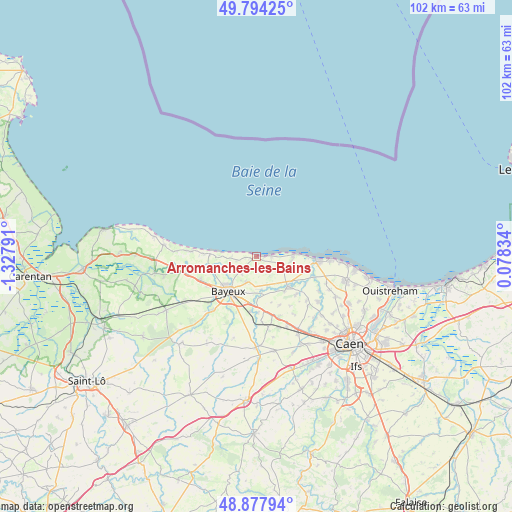
Arromanches-les-Bains GPS coordinates[2]
49° 20' 17.628" North, 0° 37' 29.244" West
| Map corner | latitude | longitude |
|---|---|---|
| Upper-left | 49.79425°, | -1.32791° |
| Center: | 49.33823°, | -0.62479° |
| Lower-right: | 48.87794°, | 0.07834° |
| Map W x H: | 101.9×101.9 km | = 63.3×63.3mi |
| max Lat: | 51.07786° ⇑13.2% North |
| Arromanches-les-Bains: | 49.33823° |
| min Lat: | ⇓86.8% South 41.3874° |
| min Long | Arromanches-les | max Long |
| -5.08615° | -0.62479° | 9.52242° |
| W 15.3%⇐ | ⇒84.7% E |
Elevation
Elevation of Arromanches-les-Bains is 11 m = 36 ft, and this is 182.7 m = 599 ft below average elevation for this country.
| Max E: |
2333 m = 7654 ft | 97% |
| Avg. | 193.7 m = 635 ft | |
| Arromanches-les-Bains | 11 m = 36 ft | |
Min E: |
-1 m = -3 ft | 3% |
See also: France elevation on elevation.city.
Geographical zone
Arromanches-les-Bains is located in North temperate zone (between Tropic of Cancer and the Arctic Circle). Distance of this North polar circle is 1915.3 km =1190.1 mi to North.| Distance of | km | miles | from Arromanches-les-Bains |
|---|---|---|---|
| North Pole | 4521.2 | 2809.3 | to North |
| Arctic Circle | 1915.3 | 1190.1 | to North |
| Tropic Cancer | 2880 | 1789.5 | to South |
| Equator | 5485.9 | 3408.8 | to South |


Nearby cities:
15 places around Arromanches-les-Bains: (largest is in red/bold)
• Asnelles
3 km =1.9 mi,  86°
86°
• Banville
10.4 km =6.5 mi,  105°
105°
• Bayeux
8.9 km =5.5 mi,  220°
220°
• Courseulles-sur-Mer
12.3 km =7.6 mi, 94°
• Creully
8.6 km =5.3 mi,  133°
133°
• Graye-sur-Mer
11 km =6.8 mi,  95°
95°
• Lantheuil
11 km =6.8 mi,  135°
135°
• Le Fresne-Camilly
13.2 km =8.2 mi, 131°
• Longues-sur-Mer
4.9 km =3 mi,  269°
269°
• Port-en-Bessin-Huppain
9.5 km =5.9 mi, 274°
• Saint-Martin-des-Entrées
8.6 km =5.3 mi,  203°
203°
• Saint-Vigor-le-Grand
7.6 km =4.7 mi, 215°
• Sommervieu
5.3 km =3.3 mi, 196°
• Tour-en-Bessin
12 km =7.5 mi,  247°
247°
• Ver-sur-Mer
6.8 km =4.2 mi, 97°
Sources, notices
• [Note1] Compared only with cities in France existing in our database
• [Src1] Map data: © OpenStreetMap contributors (CC-BY-SA)
• [Src2] Other city data from geonames.org with taken over terms of usage.
• [Src3] Geographical zone / Annual Mean Temperature by Robert A. Rohde @ Wikipedia
