Courçon geodata
Courçon (Nouvelle-Aquitaine) is a populated place; located in France in Europe/Paris (GMT+2) time zone. With population of 1,173 people, there are 7685 cities with bigger population in this country. Compared to other cities in France, 63% of cities are located further ↑North; 86.6% of cities are located further →East and 93.9% of cities have higher elevation than Courçon. Note1
Administrative division(s):
- Level 1: Nouvelle-Aquitaine
- Level 2: Charente-Maritime
- Level 3: Arrondissement de La Rochelle
- Level 4: Courçon


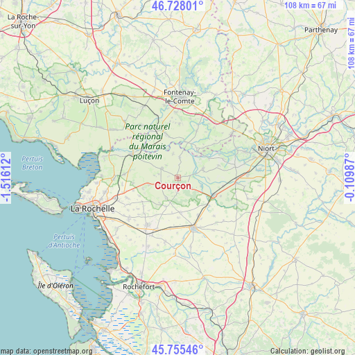
Courçon GPS coordinates[2]
46° 14' 38.004" North, 0° 48' 46.8" West
| Map corner | latitude | longitude |
|---|---|---|
| Upper-left | 46.72801°, | -1.51612° |
| Center: | 46.24389°, | -0.813° |
| Lower-right: | 45.75546°, | -0.10987° |
| Map W x H: | 108.1×108.1 km | = 67.2×67.2mi |
| max Lat: | 51.07786° ⇑63% North |
| Courçon: | 46.24389° |
| min Lat: | ⇓37% South 41.3874° |
| min Long | Courçon | max Long |
| -5.08615° | -0.813° | 9.52242° |
| W 13.4%⇐ | ⇒86.6% E |
Elevation
Elevation of Courçon is 20 m = 66 ft, and this is 173.7 m = 570 ft below average elevation for this country.
| Max E: |
2333 m = 7654 ft | 93.9% |
| Avg. | 193.7 m = 635 ft | |
| Courçon | 20 m = 66 ft | |
Min E: |
-1 m = -3 ft | 6.1% |
See also: France elevation on elevation.city.
Geographical zone
Courçon is located in North temperate zone (between Tropic of Cancer and the Arctic Circle). Distance of this North polar circle is 2259.3 km =1403.9 mi to North.| Distance of | km | miles | from Courçon |
|---|---|---|---|
| North Pole | 4865.2 | 3023.1 | to North |
| Arctic Circle | 2259.3 | 1403.9 | to North |
| Tropic Cancer | 2535.9 | 1575.7 | to South |
| Equator | 5141.8 | 3195 | to South |


Nearby cities:
15 places around Courçon: (largest is in red/bold)
• Arçais
11 km =6.8 mi,  57°
57°
• Benon
4.3 km =2.7 mi,  183°
183°
• Chambon
13.2 km =8.2 mi,  192°
192°
• Cramchaban
8 km =5 mi,  112°
112°
• Damvix
10 km =6.2 mi,  37°
37°
• La Ronde
6.1 km =3.8 mi,  4°
4°
• Longèves
13.8 km =8.6 mi,  263°
263°
• Maillé
11.1 km =6.9 mi,  10°
10°
• Mauzé-sur-le-Mignon
12.4 km =7.7 mi,  115°
115°
• Saint-Georges-du-Bois
13 km =8.1 mi,  152°
152°
• Saint-Hilaire-la-Palud
8 km =5 mi,  73°
73°
• Saint-Jean-de-Liversay
5.4 km =3.4 mi,  300°
300°
• Saint-Sauveur-d’Aunis
6.3 km =3.9 mi,  242°
242°
• Taugon
7.4 km =4.6 mi,  347°
347°
• Vérines
13.1 km =8.1 mi, 244°
Sources, notices
• [Note1] Compared only with cities in France existing in our database
• [Src1] Map data: © OpenStreetMap contributors (CC-BY-SA)
• [Src2] Other city data from geonames.org with taken over terms of usage.
• [Src3] Geographical zone / Annual Mean Temperature by Robert A. Rohde @ Wikipedia
