Arçais geodata
Arçais (Nouvelle-Aquitaine) is a populated place; located in France in Europe/Paris (GMT+2) time zone. With population of 646 people, there are 12578 cities with bigger population in this country. Compared to other cities in France, 62.4% of cities are located further ↑North; 85.5% of cities are located further →East and 95.4% of cities have higher elevation than Arçais. Note1
Administrative division(s):
- Level 1: Nouvelle-Aquitaine
- Level 2: Département des Deux-Sèvres
- Level 3: Arrondissement de Niort
- Level 4: Arçais


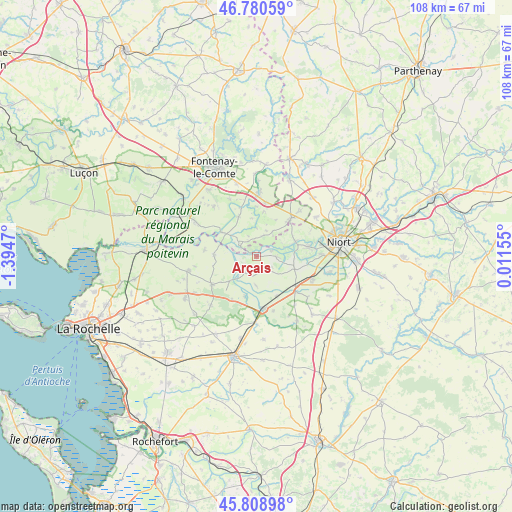
Arçais GPS coordinates[2]
46° 17' 48.984" North, 0° 41' 29.688" West
| Map corner | latitude | longitude |
|---|---|---|
| Upper-left | 46.78059°, | -1.3947° |
| Center: | 46.29694°, | -0.69158° |
| Lower-right: | 45.80898°, | 0.01155° |
| Map W x H: | 108×108 km | = 67.1×67.1mi |
| max Lat: | 51.07786° ⇑62.4% North |
| Arçais: | 46.29694° |
| min Lat: | ⇓37.6% South 41.3874° |
| min Long | Arçais | max Long |
| -5.08615° | -0.69158° | 9.52242° |
| W 14.5%⇐ | ⇒85.5% E |
Elevation
Elevation of Arçais is 16 m = 52 ft, and this is 177.7 m = 583 ft below average elevation for this country.
| Max E: |
2333 m = 7654 ft | 95.4% |
| Avg. | 193.7 m = 635 ft | |
| Arçais | 16 m = 52 ft | |
Min E: |
-1 m = -3 ft | 4.6% |
See also: France elevation on elevation.city.
Geographical zone
Arçais is located in North temperate zone (between Tropic of Cancer and the Arctic Circle). Distance of this North polar circle is 2253.4 km =1400.2 mi to North.| Distance of | km | miles | from Arçais |
|---|---|---|---|
| North Pole | 4859.3 | 3019.4 | to North |
| Arctic Circle | 2253.4 | 1400.2 | to North |
| Tropic Cancer | 2541.8 | 1579.4 | to South |
| Equator | 5147.7 | 3198.6 | to South |


Nearby cities:
15 places around Arçais: (largest is in red/bold)
• Benet
11.1 km =6.9 mi,  42°
42°
• Coulon
8.7 km =5.4 mi,  69°
69°
• Courçon
11 km =6.8 mi,  237°
237°
• Cramchaban
9.1 km =5.7 mi,  192°
192°
• Damvix
3.8 km =2.4 mi,  302°
302°
• La Ronde
8.9 km =5.5 mi,  271°
271°
• Magné
11.3 km =7 mi,  79°
79°
• Maillezais
9.2 km =5.7 mi,  336°
336°
• Maillé
8.9 km =5.5 mi, 304°
• Mauzé-sur-le-Mignon
11.4 km =7.1 mi,  170°
170°
• Saint-Hilaire-la-Palud
4 km =2.5 mi,  204°
204°
• Saint-Pierre-le-Vieux
10.9 km =6.8 mi, 336°
• Sansais
8.4 km =5.2 mi,  107°
107°
• Taugon
11.1 km =6.9 mi,  276°
276°
• Épannes
11.1 km =6.9 mi,  131°
131°
Sources, notices
• [Note1] Compared only with cities in France existing in our database
• [Src1] Map data: © OpenStreetMap contributors (CC-BY-SA)
• [Src2] Other city data from geonames.org with taken over terms of usage.
• [Src3] Geographical zone / Annual Mean Temperature by Robert A. Rohde @ Wikipedia
