Couffy geodata
Couffy (Centre) is a populated place; located in France in Europe/Paris (GMT+2) time zone. With population of 586 people, there are 13542 cities with bigger population in this country. Compared to other cities in France, 52.4% of cities are located further ↑North; 63.8% of cities are located further →East and 68.7% of cities have higher elevation than Couffy. Note1
Administrative division(s):
- Level 1: Centre
- Level 2: Département du Loir-et-Cher
- Level 3: Arrondissement de Romorantin-Lanthenay
- Level 4: Couffy


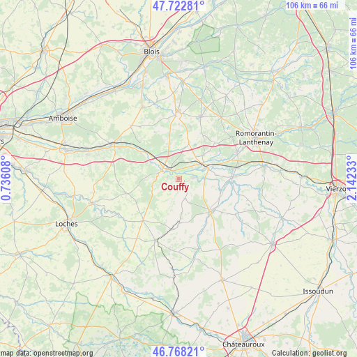
Couffy GPS coordinates[2]
47° 14' 51.576" North, 1° 26' 21.156" East
| Map corner | latitude | longitude |
|---|---|---|
| Upper-left | 47.72281°, | 0.73608° |
| Center: | 47.24766°, | 1.43921° |
| Lower-right: | 46.76821°, | 2.14233° |
| Map W x H: | 106.1×106.1 km | = 65.9×65.9mi |
| max Lat: | 51.07786° ⇑52.4% North |
| Couffy: | 47.24766° |
| min Lat: | ⇓47.6% South 41.3874° |
| min Long | Couffy | max Long |
| -5.08615° | 1.43921° | 9.52242° |
| W 36.2%⇐ | ⇒63.8% E |
Elevation
Elevation of Couffy is 81 m = 266 ft, and this is 112.7 m = 370 ft below average elevation for this country.
| Max E: |
2333 m = 7654 ft | 68.7% |
| Avg. | 193.7 m = 635 ft | |
| Couffy | 81 m = 266 ft | |
Min E: |
-1 m = -3 ft | 31.3% |
See also: France elevation on elevation.city.
Geographical zone
Couffy is located in North temperate zone (between Tropic of Cancer and the Arctic Circle). Distance of this North polar circle is 2147.7 km =1334.5 mi to North.| Distance of | km | miles | from Couffy |
|---|---|---|---|
| North Pole | 4753.6 | 2953.7 | to North |
| Arctic Circle | 2147.7 | 1334.5 | to North |
| Tropic Cancer | 2647.5 | 1645.1 | to South |
| Equator | 5253.4 | 3264.3 | to South |


Nearby cities:
15 places around Couffy: (largest is in red/bold)
• Billy
10.4 km =6.5 mi,  46°
46°
• Châteauvieux
4.6 km =2.9 mi,  246°
246°
• Châtillon-sur-Cher
5.2 km =3.2 mi, 53°
• Chémery
11.4 km =7.1 mi,  15°
15°
• La Vernelle
7.8 km =4.8 mi,  89°
89°
• Lye
3.4 km =2.1 mi,  129°
129°
• Mareuil-sur-Cher
9.7 km =6 mi,  301°
301°
• Meusnes
4.4 km =2.7 mi, 88°
• Noyers-sur-Cher
4.2 km =2.6 mi,  320°
320°
• Saint-Aignan
5.3 km =3.3 mi, 296°
• Saint-Romain-sur-Cher
8.5 km =5.3 mi,  339°
339°
• Seigy
3.2 km =2 mi,  288°
288°
• Selles-sur-Cher
9.3 km =5.8 mi,  68°
68°
• Thésée
13 km =8.1 mi,  310°
310°
• Villentrois
6.2 km =3.9 mi,  163°
163°
Sources, notices
• [Note1] Compared only with cities in France existing in our database
• [Src1] Map data: © OpenStreetMap contributors (CC-BY-SA)
• [Src2] Other city data from geonames.org with taken over terms of usage.
• [Src3] Geographical zone / Annual Mean Temperature by Robert A. Rohde @ Wikipedia
