Selles-sur-Cher geodata
Selles-sur-Cher (Centre) is a populated place; located in France in Europe/Paris (GMT+2) time zone. With population of 4,933 people, there are 2007 cities with bigger population in this country. Compared to other cities in France, 51.9% of cities are located further ↑North; 62.3% of cities are located further →East and 69.2% of cities have higher elevation than Selles-sur-Cher. Note1
Administrative division(s):
- Level 1: Centre
- Level 2: Département du Loir-et-Cher
- Level 3: Arrondissement de Romorantin-Lanthenay
- Level 4: Selles-sur-Cher


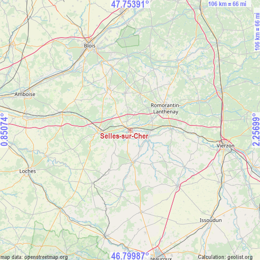
Selles-sur-Cher GPS coordinates[2]
47° 16' 44.544" North, 1° 33' 13.932" East
| Map corner | latitude | longitude |
|---|---|---|
| Upper-left | 47.75391°, | 0.85074° |
| Center: | 47.27904°, | 1.55387° |
| Lower-right: | 46.79987°, | 2.25699° |
| Map W x H: | 106.1×106.1 km | = 65.9×65.9mi |
| max Lat: | 51.07786° ⇑51.9% North |
| Selles-sur-Cher: | 47.27904° |
| min Lat: | ⇓48.1% South 41.3874° |
| min Long | Selles-sur-Cher | max Long |
| -5.08615° | 1.55387° | 9.52242° |
| W 37.7%⇐ | ⇒62.3% E |
Elevation
Elevation of Selles-sur-Cher is 80 m = 262 ft, and this is 113.7 m = 373 ft below average elevation for this country.
| Max E: |
2333 m = 7654 ft | 69.2% |
| Avg. | 193.7 m = 635 ft | |
| Selles-sur-Cher | 80 m = 262 ft | |
Min E: |
-1 m = -3 ft | 30.8% |
See also: France elevation on elevation.city.
Geographical zone
Selles-sur-Cher is located in North temperate zone (between Tropic of Cancer and the Arctic Circle). Distance of this North polar circle is 2144.2 km =1332.3 mi to North.| Distance of | km | miles | from Selles-sur-Cher |
|---|---|---|---|
| North Pole | 4750.1 | 2951.6 | to North |
| Arctic Circle | 2144.2 | 1332.3 | to North |
| Tropic Cancer | 2651 | 1647.3 | to South |
| Equator | 5256.9 | 3266.5 | to South |


Nearby cities:
15 places around Selles-sur-Cher: (largest is in red/bold)
• Billy
3.9 km =2.4 mi,  343°
343°
• Chabris
7.9 km =4.9 mi,  111°
111°
• Châtillon-sur-Cher
4.5 km =2.8 mi,  265°
265°
• Chémery
9.4 km =5.8 mi,  323°
323°
• Couffy
9.3 km =5.8 mi,  248°
248°
• Gièvres
8.7 km =5.4 mi,  90°
90°
• Gy-en-Sologne
7.6 km =4.7 mi,  16°
16°
• La Vernelle
3.5 km =2.2 mi,  193°
193°
• Lye
8.3 km =5.2 mi,  226°
226°
• Meusnes
5.4 km =3.4 mi, 232°
• Noyers-sur-Cher
11.4 km =7.1 mi, 268°
• Pruniers-en-Sologne
9.5 km =5.9 mi,  63°
63°
• Seigy
11.9 km =7.4 mi,  258°
258°
• Varennes-sur-Fouzon
8.3 km =5.2 mi,  152°
152°
• Villentrois
11.7 km =7.3 mi,  216°
216°
Sources, notices
• [Note1] Compared only with cities in France existing in our database
• [Src1] Map data: © OpenStreetMap contributors (CC-BY-SA)
• [Src2] Other city data from geonames.org with taken over terms of usage.
• [Src3] Geographical zone / Annual Mean Temperature by Robert A. Rohde @ Wikipedia
