Couddes geodata
Couddes (Centre) is a populated place; located in France in Europe/Paris (GMT+2) time zone. With population of 511 people, there are 15016 cities with bigger population in this country. Compared to other cities in France, 50.6% of cities are located further ↑North; 64.2% of cities are located further →East and 56.2% of cities have higher elevation than Couddes. Note1
Administrative division(s):
- Level 1: Centre
- Level 2: Département du Loir-et-Cher
- Level 3: Arrondissement de Romorantin-Lanthenay
- Level 4: Couddes


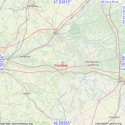
Couddes GPS coordinates[2]
47° 21' 50.58" North, 1° 24' 15.696" East
| Map corner | latitude | longitude |
|---|---|---|
| Upper-left | 47.83815°, | 0.70124° |
| Center: | 47.36405°, | 1.40436° |
| Lower-right: | 46.88565°, | 2.10749° |
| Map W x H: | 105.9×105.9 km | = 65.8×65.8mi |
| max Lat: | 51.07786° ⇑50.6% North |
| Couddes: | 47.36405° |
| min Lat: | ⇓49.4% South 41.3874° |
| min Long | Couddes | max Long |
| -5.08615° | 1.40436° | 9.52242° |
| W 35.8%⇐ | ⇒64.2% E |
Elevation
Elevation of Couddes is 113 m = 371 ft, and this is 80.7 m = 265 ft below average elevation for this country.
| Max E: |
2333 m = 7654 ft | 56.2% |
| Avg. | 193.7 m = 635 ft | |
| Couddes | 113 m = 371 ft | |
Min E: |
-1 m = -3 ft | 43.8% |
See also: France elevation on elevation.city.
Geographical zone
Couddes is located in North temperate zone (between Tropic of Cancer and the Arctic Circle). Distance of this North polar circle is 2134.8 km =1326.5 mi to North.| Distance of | km | miles | from Couddes |
|---|---|---|---|
| North Pole | 4740.7 | 2945.7 | to North |
| Arctic Circle | 2134.8 | 1326.5 | to North |
| Tropic Cancer | 2660.5 | 1653.2 | to South |
| Equator | 5266.4 | 3272.4 | to South |


Nearby cities:
15 places around Couddes: (largest is in red/bold)
• Chémery
5.9 km =3.7 mi,  108°
108°
• Contres
6.2 km =3.9 mi,  16°
16°
• Feings
9.1 km =5.7 mi,  335°
335°
• Fougères-sur-Bièvre
10.5 km =6.5 mi,  333°
333°
• Fresnes
7.9 km =4.9 mi,  4°
4°
• Mareuil-sur-Cher
9.7 km =6 mi,  215°
215°
• Monthou-sur-Cher
8.2 km =5.1 mi,  257°
257°
• Noyers-sur-Cher
9.7 km =6 mi,  180°
180°
• Pouillé
10.1 km =6.3 mi,  238°
238°
• Saint-Aignan
10.8 km =6.7 mi,  191°
191°
• Saint-Romain-sur-Cher
5 km =3.1 mi, 184°
• Sassay
4.4 km =2.7 mi,  39°
39°
• Soings-en-Sologne
10.6 km =6.6 mi,  59°
59°
• Thenay
8.9 km =5.5 mi,  287°
287°
• Thésée
8.5 km =5.3 mi, 237°
Sources, notices
• [Note1] Compared only with cities in France existing in our database
• [Src1] Map data: © OpenStreetMap contributors (CC-BY-SA)
• [Src2] Other city data from geonames.org with taken over terms of usage.
• [Src3] Geographical zone / Annual Mean Temperature by Robert A. Rohde @ Wikipedia
