Soings-en-Sologne geodata
Soings-en-Sologne (Centre) is a populated place; located in France in Europe/Paris (GMT+2) time zone. With population of 1,357 people, there are 6778 cities with bigger population in this country. Compared to other cities in France, 50.1% of cities are located further ↓South; 62.7% of cities are located further →East and 56.9% of cities have higher elevation than Soings-en-Sologne. Note1
Administrative division(s):
- Level 1: Centre
- Level 2: Département du Loir-et-Cher
- Level 3: Arrondissement de Romorantin-Lanthenay
- Level 4: Soings-en-Sologne


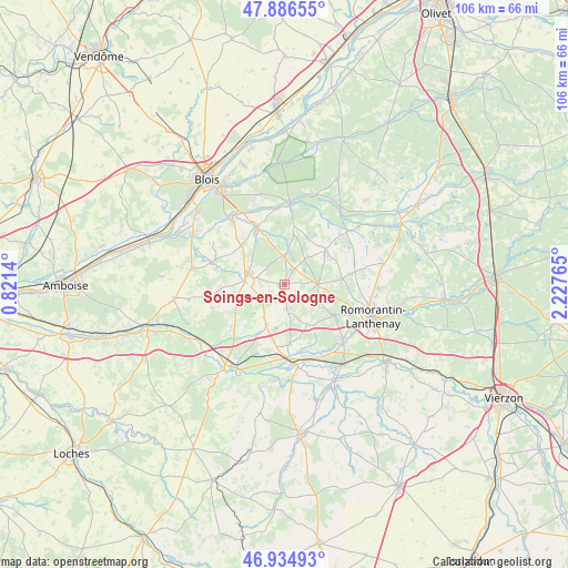
Soings-en-Sologne GPS coordinates[2]
47° 24' 46.404" North, 1° 31' 28.272" East
| Map corner | latitude | longitude |
|---|---|---|
| Upper-left | 47.88655°, | 0.8214° |
| Center: | 47.41289°, | 1.52452° |
| Lower-right: | 46.93493°, | 2.22765° |
| Map W x H: | 105.8×105.8 km | = 65.7×65.7mi |
| max Lat: | 51.07786° ⇑49.9% North |
| Soings-en-Sologne: | 47.41289° |
| min Lat: | ⇓50.1% South 41.3874° |
| min Long | Soings-en-Solog | max Long |
| -5.08615° | 1.52452° | 9.52242° |
| W 37.3%⇐ | ⇒62.7% E |
Elevation
Elevation of Soings-en-Sologne is 111 m = 364 ft, and this is 82.7 m = 271 ft below average elevation for this country.
| Max E: |
2333 m = 7654 ft | 56.9% |
| Avg. | 193.7 m = 635 ft | |
| Soings-en-Sologne | 111 m = 364 ft | |
Min E: |
-1 m = -3 ft | 43.1% |
See also: France elevation on elevation.city.
Geographical zone
Soings-en-Sologne is located in North temperate zone (between Tropic of Cancer and the Arctic Circle). Distance of this North polar circle is 2129.4 km =1323.1 mi to North.| Distance of | km | miles | from Soings-en-Sologne |
|---|---|---|---|
| North Pole | 4735.2 | 2942.3 | to North |
| Arctic Circle | 2129.4 | 1323.1 | to North |
| Tropic Cancer | 2665.9 | 1656.5 | to South |
| Equator | 5271.8 | 3275.7 | to South |


Nearby cities:
15 places around Soings-en-Sologne: (largest is in red/bold)
• Billy
11.2 km =7 mi,  174°
174°
• Cheverny
10.9 km =6.8 mi,  333°
333°
• Chémery
8.1 km =5 mi,  205°
205°
• Contres
7.2 km =4.5 mi,  274°
274°
• Cormeray
12.5 km =7.8 mi,  314°
314°
• Couddes
10.6 km =6.6 mi,  239°
239°
• Cour-Cheverny
12 km =7.5 mi, 334°
• Feings
13.2 km =8.2 mi,  282°
282°
• Fontaines-en-Sologne
10.9 km =6.8 mi,  10°
10°
• Fresnes
8.8 km =5.5 mi,  286°
286°
• Gy-en-Sologne
8.8 km =5.5 mi,  150°
150°
• Mur-de-Sologne
6.3 km =3.9 mi,  90°
90°
• Saint-Romain-sur-Cher
14.1 km =8.8 mi,  221°
221°
• Sassay
6.6 km =4.1 mi,  251°
251°
• Tour-en-Sologne
14.2 km =8.8 mi,  354°
354°
Sources, notices
• [Note1] Compared only with cities in France existing in our database
• [Src1] Map data: © OpenStreetMap contributors (CC-BY-SA)
• [Src2] Other city data from geonames.org with taken over terms of usage.
• [Src3] Geographical zone / Annual Mean Temperature by Robert A. Rohde @ Wikipedia
