Couchey geodata
Couchey (Bourgogne-Franche-Comté) is a populated place; located in France in Europe/Paris (GMT+2) time zone. With population of 1,224 people, there are 7415 cities with bigger population in this country. Compared to other cities in France, 52.2% of cities are located further ↑North; 77.5% of cities are located further ←West and 78.6% of cities have lower elevation than Couchey. Note1
Administrative division(s):
- Level 1: Bourgogne-Franche-Comté
- Level 2: Département de la Côte-d'Or
- Level 3: Arrondissement de Beaune
- Level 4: Couchey


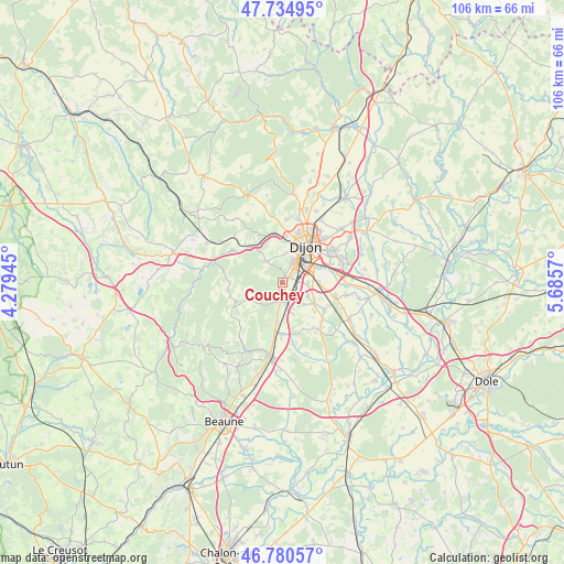
Couchey GPS coordinates[2]
47° 15' 35.676" North, 4° 58' 57.252" East
| Map corner | latitude | longitude |
|---|---|---|
| Upper-left | 47.73495°, | 4.27945° |
| Center: | 47.25991°, | 4.98257° |
| Lower-right: | 46.78057°, | 5.6857° |
| Map W x H: | 106.1×106.1 km | = 65.9×65.9mi |
| max Lat: | 51.07786° ⇑52.2% North |
| Couchey: | 47.25991° |
| min Lat: | ⇓47.8% South 41.3874° |
| min Long | Couchey | max Long |
| -5.08615° | 4.98257° | 9.52242° |
| W 77.5%⇐ | ⇒22.5% E |
Elevation
Elevation of Couchey is 278 m = 912 ft, and this is 84.3 m = 277 ft above average elevation for this country.
| Max E: |
2333 m = 7654 ft | 21.4% |
| Couchey | 278 m 912 ft | |
| Avg. | 193.7 m = 635 ft | |
Min E: |
-1 m = -3 ft | 78.6% |
See also: France elevation on elevation.city.
Geographical zone
Couchey is located in North temperate zone (between Tropic of Cancer and the Arctic Circle). Distance of this North polar circle is 2146.4 km =1333.7 mi to North.| Distance of | km | miles | from Couchey |
|---|---|---|---|
| North Pole | 4752.3 | 2952.9 | to North |
| Arctic Circle | 2146.4 | 1333.7 | to North |
| Tropic Cancer | 2648.9 | 1645.9 | to South |
| Equator | 5254.8 | 3265.2 | to South |


Nearby cities:
15 places around Couchey: (largest is in red/bold)
• Brochon
2.6 km =1.6 mi,  203°
203°
• Chenôve
4.1 km =2.5 mi,  24°
24°
• Corcelles-les-Monts
5 km =3.1 mi,  320°
320°
• Dijon
6.8 km =4.2 mi, 22°
• Fixin
1.8 km =1.1 mi, 203°
• Fénay
6.8 km =4.2 mi,  117°
117°
• Gevrey-Chambertin
3.9 km =2.4 mi, 196°
• Longvic
6.8 km =4.2 mi,  63°
63°
• Marsannay-la-Côte
1.3 km =0.8 mi, 21°
• Morey-Saint-Denis
7.2 km =4.5 mi,  192°
192°
• Ouges
6.9 km =4.3 mi,  88°
88°
• Perrigny-lès-Dijon
1.9 km =1.2 mi,  67°
67°
• Plombières-lès-Dijon
8.3 km =5.2 mi,  351°
351°
• Saulon-la-Rue
7.5 km =4.7 mi, 124°
• Talant
8.8 km =5.5 mi,  13°
13°
Sources, notices
• [Note1] Compared only with cities in France existing in our database
• [Src1] Map data: © OpenStreetMap contributors (CC-BY-SA)
• [Src2] Other city data from geonames.org with taken over terms of usage.
• [Src3] Geographical zone / Annual Mean Temperature by Robert A. Rohde @ Wikipedia
