Gevrey-Chambertin geodata
Gevrey-Chambertin (Bourgogne-Franche-Comté) is a populated place; located in France in Europe/Paris (GMT+2) time zone. With population of 3,356 people, there are 2908 cities with bigger population in this country. Compared to other cities in France, 52.6% of cities are located further ↑North; 77.3% of cities are located further ←West and 79.1% of cities have lower elevation than Gevrey-Chambertin. Note1
Administrative division(s):
- Level 1: Bourgogne-Franche-Comté
- Level 2: Département de la Côte-d'Or
- Level 3: Arrondissement de Beaune
- Level 4: Gevrey-Chambertin


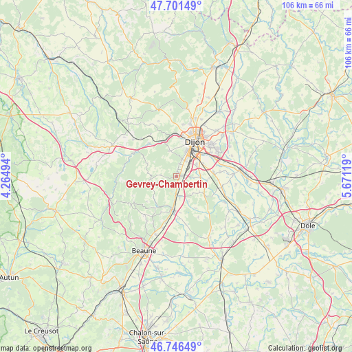
Gevrey-Chambertin GPS coordinates[2]
47° 13' 34.104" North, 4° 58' 5.016" East
| Map corner | latitude | longitude |
|---|---|---|
| Upper-left | 47.70149°, | 4.26494° |
| Center: | 47.22614°, | 4.96806° |
| Lower-right: | 46.74649°, | 5.67119° |
| Map W x H: | 106.2×106.2 km | = 66×66mi |
| max Lat: | 51.07786° ⇑52.6% North |
| Gevrey-Chambertin: | 47.22614° |
| min Lat: | ⇓47.4% South 41.3874° |
| min Long | Gevrey-Chambert | max Long |
| -5.08615° | 4.96806° | 9.52242° |
| W 77.3%⇐ | ⇒22.7% E |
Elevation
Elevation of Gevrey-Chambertin is 281 m = 922 ft, and this is 87.3 m = 286 ft above average elevation for this country.
| Max E: |
2333 m = 7654 ft | 20.9% |
| Gevrey-Chambertin | 281 m 922 ft | |
| Avg. | 193.7 m = 635 ft | |
Min E: |
-1 m = -3 ft | 79.1% |
See also: France elevation on elevation.city.
Geographical zone
Gevrey-Chambertin is located in North temperate zone (between Tropic of Cancer and the Arctic Circle). Distance of this North polar circle is 2150.1 km =1336 mi to North.| Distance of | km | miles | from Gevrey-Chambertin |
|---|---|---|---|
| North Pole | 4756 | 2955.2 | to North |
| Arctic Circle | 2150.1 | 1336 | to North |
| Tropic Cancer | 2645.1 | 1643.6 | to South |
| Equator | 5251.1 | 3262.9 | to South |


Nearby cities:
15 places around Gevrey-Chambertin: (largest is in red/bold)
• Brochon
1.4 km =0.9 mi,  3°
3°
• Chenôve
8 km =5 mi,  20°
20°
• Corcelles-les-Monts
7.9 km =4.9 mi,  344°
344°
• Couchey
3.9 km =2.4 mi, 16°
• Fixin
2.1 km =1.3 mi,  10°
10°
• Flagey-Echézeaux
6.7 km =4.2 mi,  170°
170°
• Fénay
7.1 km =4.4 mi,  84°
84°
• Gilly-lès-Cîteaux
6.8 km =4.2 mi, 171°
• Marsannay-la-Côte
5.2 km =3.2 mi, 17°
• Morey-Saint-Denis
3.3 km =2.1 mi,  187°
187°
• Noiron-sous-Gevrey
9.1 km =5.7 mi,  113°
113°
• Ouges
8.9 km =5.5 mi,  63°
63°
• Perrigny-lès-Dijon
5.3 km =3.3 mi,  32°
32°
• Saulon-la-Chapelle
9.2 km =5.7 mi,  97°
97°
• Saulon-la-Rue
7.2 km =4.5 mi,  94°
94°
Sources, notices
• [Note1] Compared only with cities in France existing in our database
• [Src1] Map data: © OpenStreetMap contributors (CC-BY-SA)
• [Src2] Other city data from geonames.org with taken over terms of usage.
• [Src3] Geographical zone / Annual Mean Temperature by Robert A. Rohde @ Wikipedia
