Corte geodata
Corte (Corsica) is a seat of a third-order administrative division; located in France in Europe/Paris (GMT+2) time zone. With population of 7,217 people, there are 1352 cities with bigger population in this country. Compared to other cities in France, 99.7% of cities are located further ↑North; 99.7% of cities are located further ←West and 90.3% of cities have lower elevation than Corte. Note1
Administrative division(s):
- Level 1: Corsica
- Level 2: Département de la Haute-Corse
- Level 3: Arrondissement de Corte
- Level 4: Corte


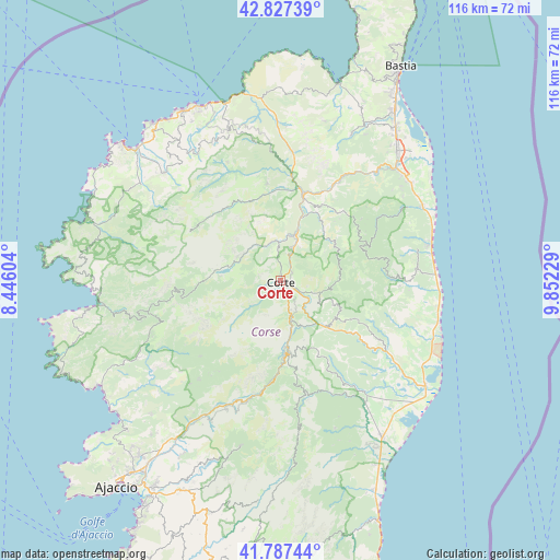
Corte GPS coordinates[2]
42° 18' 34.416" North, 9° 8' 57.012" East
| Map corner | latitude | longitude |
|---|---|---|
| Upper-left | 42.82739°, | 8.44604° |
| Center: | 42.30956°, | 9.14917° |
| Lower-right: | 41.78744°, | 9.85229° |
| Map W x H: | 115.6×115.6 km | = 71.8×71.8mi |
| max Lat: | 51.07786° ⇑99.7% North |
| Corte: | 42.30956° |
| min Lat: | ⇓0.3% South 41.3874° |
| min Long | Corte | max Long |
| -5.08615° | 9.14917° | 9.52242° |
| W 99.7%⇐ | ⇒0.3% E |
Elevation
Elevation of Corte is 433 m = 1421 ft, and this is 239.3 m = 785 ft above average elevation for this country.
| Max E: |
2333 m = 7654 ft | 9.7% |
| Corte | 433 m 1421 ft | |
| Avg. | 193.7 m = 635 ft | |
Min E: |
-1 m = -3 ft | 90.3% |
See also: France elevation on elevation.city.
Geographical zone
Corte is located in North temperate zone (between Tropic of Cancer and the Arctic Circle). Distance of this Northern Tropic circle is 2098.5 km =1303.9 mi to South.| Distance of | km | miles | from Corte |
|---|---|---|---|
| North Pole | 5302.7 | 3294.9 | to North |
| Arctic Circle | 2696.8 | 1675.7 | to North |
| Tropic Cancer | 2098.5 | 1303.9 | to South |
| Equator | 4704.4 | 2923.2 | to South |


Nearby cities:
15 places around Corte: (largest is in red/bold)
• Casevecchie
25.6 km =15.9 mi,  139°
139°
• Cervione
28.4 km =17.6 mi,  85°
85°
• Linguizzetta
27.1 km =16.8 mi,  100°
100°
• Moltifao
19.9 km =12.4 mi,  351°
351°
• Morosaglia
18.7 km =11.6 mi,  41°
41°
• Omessa
7.9 km =4.9 mi,  31°
31°
• Penta-di-Casinca
30.8 km =19.1 mi,  55°
55°
• Poggio-di-Venaco
6.5 km =4 mi,  151°
151°
• San-Giuliano
30.2 km =18.8 mi, 89°
• Santa-Maria-Poggio
28.7 km =17.8 mi,  82°
82°
• Taglio
29.8 km =18.5 mi, 62°
• Talasani
29.3 km =18.2 mi,  67°
67°
• Venaco
8.8 km =5.5 mi,  167°
167°
• Vignale
23 km =14.3 mi, 39°
• Vivario
15.5 km =9.6 mi, 173°
Sources, notices
• [Note1] Compared only with cities in France existing in our database
• [Src1] Map data: © OpenStreetMap contributors (CC-BY-SA)
• [Src2] Other city data from geonames.org with taken over terms of usage.
• [Src3] Geographical zone / Annual Mean Temperature by Robert A. Rohde @ Wikipedia
