Cervione geodata
Cervione (Corsica) is a populated place; located in France in Europe/Paris (GMT+2) time zone. With population of 1,589 people, there are 5873 cities with bigger population in this country. Compared to other cities in France, 99.7% of cities are located further ↑North; 100% of cities are located further ←West and 51.7% of cities have lower elevation than Cervione. Note1
Administrative division(s):
- Level 1: Corsica
- Level 2: Département de la Haute-Corse
- Level 3: Arrondissement de Corte
- Level 4: Cervione


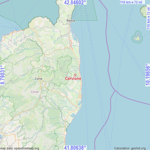
Cervione GPS coordinates[2]
42° 19' 42.06" North, 9° 29' 36.348" East
| Map corner | latitude | longitude |
|---|---|---|
| Upper-left | 42.84602°, | 8.79031° |
| Center: | 42.32835°, | 9.49343° |
| Lower-right: | 41.80638°, | 10.19656° |
| Map W x H: | 115.6×115.6 km | = 71.8×71.8mi |
| max Lat: | 51.07786° ⇑99.7% North |
| Cervione: | 42.32835° |
| min Lat: | ⇓0.3% South 41.3874° |
| min Long | Cervione | max Long |
| -5.08615° | 9.49343° | 9.52242° |
| W 100%⇐ | ⇒0% E |
Elevation
Elevation of Cervione is 138 m = 453 ft, and this is 55.7 m = 183 ft below average elevation for this country.
| Max E: |
2333 m = 7654 ft | 48.3% |
| Avg. | 193.7 m = 635 ft | |
| Cervione | 138 m = 453 ft | |
Min E: |
-1 m = -3 ft | 51.7% |
See also: France elevation on elevation.city.
Geographical zone
Cervione is located in North temperate zone (between Tropic of Cancer and the Arctic Circle). Distance of this Northern Tropic circle is 2100.6 km =1305.3 mi to South.| Distance of | km | miles | from Cervione |
|---|---|---|---|
| North Pole | 5300.6 | 3293.6 | to North |
| Arctic Circle | 2694.7 | 1674.4 | to North |
| Tropic Cancer | 2100.6 | 1305.3 | to South |
| Equator | 4706.5 | 2924.5 | to South |


Nearby cities:
15 places around Cervione: (largest is in red/bold)
• Casevecchie
24.7 km =15.3 mi,  208°
208°
• Castellare-di-Casinca
15.6 km =9.7 mi,  354°
354°
• Linguizzetta
7.4 km =4.6 mi,  193°
193°
• Morosaglia
19.8 km =12.3 mi,  306°
306°
• Omessa
24.6 km =15.3 mi,  280°
280°
• Penta-di-Casinca
15.5 km =9.6 mi, 349°
• San-Giuliano
2.6 km =1.6 mi,  133°
133°
• San-Nicolao
4.9 km =3 mi,  20°
20°
• Santa-Lucia-di-Moriani
6.4 km =4 mi, 21°
• Santa-Maria-Poggio
1.8 km =1.1 mi,  4°
4°
• Sorbo-Ocagnano
16.7 km =10.4 mi, 349°
• Taglio
12 km =7.5 mi, 350°
• Talasani
9 km =5.6 mi, 352°
• Vescovato
18.8 km =11.7 mi, 346°
• Vignale
20.9 km =13 mi,  318°
318°
Sources, notices
• [Note1] Compared only with cities in France existing in our database
• [Src1] Map data: © OpenStreetMap contributors (CC-BY-SA)
• [Src2] Other city data from geonames.org with taken over terms of usage.
• [Src3] Geographical zone / Annual Mean Temperature by Robert A. Rohde @ Wikipedia
