Talasani geodata
Talasani (Corsica) is a populated place; located in France in Europe/Paris (GMT+2) time zone. With population of 559 people, there are 14019 cities with bigger population in this country. Compared to other cities in France, 99.7% of cities are located further ↑North; 99.9% of cities are located further ←West and 79.1% of cities have lower elevation than Talasani. Note1
Administrative division(s):
- Level 1: Corsica
- Level 2: Département de la Haute-Corse
- Level 3: Arrondissement de Corte
- Level 4: Talasani


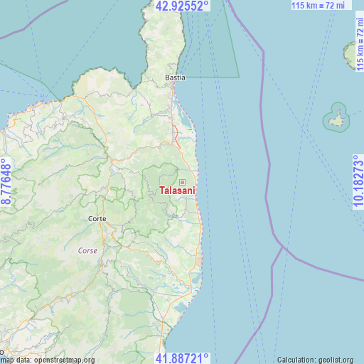
Talasani GPS coordinates[2]
42° 24' 30.636" North, 9° 28' 46.56" East
| Map corner | latitude | longitude |
|---|---|---|
| Upper-left | 42.92552°, | 8.77648° |
| Center: | 42.40851°, | 9.4796° |
| Lower-right: | 41.88721°, | 10.18273° |
| Map W x H: | 115.4×115.4 km | = 71.7×71.7mi |
| max Lat: | 51.07786° ⇑99.7% North |
| Talasani: | 42.40851° |
| min Lat: | ⇓0.3% South 41.3874° |
| min Long | Talasani | max Long |
| -5.08615° | 9.4796° | 9.52242° |
| W 99.9%⇐ | ⇒0.099999999999994% E |
Elevation
Elevation of Talasani is 281 m = 922 ft, and this is 87.3 m = 286 ft above average elevation for this country.
| Max E: |
2333 m = 7654 ft | 20.9% |
| Talasani | 281 m 922 ft | |
| Avg. | 193.7 m = 635 ft | |
Min E: |
-1 m = -3 ft | 79.1% |
See also: France elevation on elevation.city.
Geographical zone
Talasani is located in North temperate zone (between Tropic of Cancer and the Arctic Circle). Distance of this Northern Tropic circle is 2109.5 km =1310.8 mi to South.| Distance of | km | miles | from Talasani |
|---|---|---|---|
| North Pole | 5291.7 | 3288.1 | to North |
| Arctic Circle | 2685.8 | 1668.9 | to North |
| Tropic Cancer | 2109.5 | 1310.8 | to South |
| Equator | 4715.4 | 2930 | to South |


Nearby cities:
15 places around Talasani: (largest is in red/bold)
• Borgo
16.9 km =10.5 mi,  344°
344°
• Castellare-di-Casinca
6.6 km =4.1 mi,  356°
356°
• Cervione
9 km =5.6 mi,  172°
172°
• Linguizzetta
16.1 km =10 mi,  181°
181°
• Lucciana
16.1 km =10 mi, 341°
• Morosaglia
15 km =9.3 mi,  281°
281°
• Penta-di-Casinca
6.6 km =4.1 mi,  345°
345°
• San-Giuliano
11.1 km =6.9 mi,  164°
164°
• San-Nicolao
5.2 km =3.2 mi,  146°
146°
• Santa-Lucia-di-Moriani
4.6 km =2.9 mi,  129°
129°
• Santa-Maria-Poggio
7.2 km =4.5 mi, 169°
• Sorbo-Ocagnano
7.8 km =4.8 mi, 345°
• Taglio
3.1 km =1.9 mi, 344°
• Vescovato
10 km =6.2 mi, 340°
• Vignale
14.4 km =8.9 mi,  298°
298°
Sources, notices
• [Note1] Compared only with cities in France existing in our database
• [Src1] Map data: © OpenStreetMap contributors (CC-BY-SA)
• [Src2] Other city data from geonames.org with taken over terms of usage.
• [Src3] Geographical zone / Annual Mean Temperature by Robert A. Rohde @ Wikipedia
