Compiègne geodata
Compiègne (Hauts-de-France) is a seat of a third-order administrative division; located in France in Europe/Paris (GMT+2) time zone. With population of 44,243 people, there are 159 cities with bigger population in this country. Compared to other cities in France, 88.2% of cities are located further ↓South; 55.3% of cities are located further ←West and 84.9% of cities have higher elevation than Compiègne. Note1
Administrative division(s):
- Level 1: Hauts-de-France
- Level 2: Département de l'Oise
- Level 3: Arrondissement de Compiègne
- Level 4: Compiègne


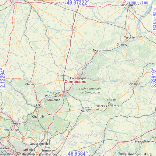
Compiègne GPS coordinates[2]
49° 25' 4.584" North, 2° 49' 33.816" East
| Map corner | latitude | longitude |
|---|---|---|
| Upper-left | 49.87322°, | 2.12294° |
| Center: | 49.41794°, | 2.82606° |
| Lower-right: | 48.9584°, | 3.52919° |
| Map W x H: | 101.7×101.7 km | = 63.2×63.2mi |
| max Lat: | 51.07786° ⇑11.8% North |
| Compiègne: | 49.41794° |
| min Lat: | ⇓88.2% South 41.3874° |
| min Long | Compiègne | max Long |
| -5.08615° | 2.82606° | 9.52242° |
| W 55.3%⇐ | ⇒44.7% E |
Elevation
Elevation of Compiègne is 42 m = 138 ft, and this is 151.7 m = 498 ft below average elevation for this country.
| Max E: |
2333 m = 7654 ft | 84.9% |
| Avg. | 193.7 m = 635 ft | |
| Compiègne | 42 m = 138 ft | |
Min E: |
-1 m = -3 ft | 15.1% |
See also: Compiègne elevation on elevation.city.
Geographical zone
Compiègne is located in North temperate zone (between Tropic of Cancer and the Arctic Circle). Distance of this North polar circle is 1906.4 km =1184.6 mi to North.| Distance of | km | miles | from Compiègne |
|---|---|---|---|
| North Pole | 4512.3 | 2803.8 | to North |
| Arctic Circle | 1906.4 | 1184.6 | to North |
| Tropic Cancer | 2888.8 | 1795 | to South |
| Equator | 5494.8 | 3414.3 | to South |


Nearby cities:
15 places around Compiègne: (largest is in red/bold)
• Armancourt
6.6 km =4.1 mi,  221°
221°
• Choisy-au-Bac
4.3 km =2.7 mi,  59°
59°
• Clairoix
3.1 km =1.9 mi,  28°
28°
• Coudun
4.9 km =3 mi,  348°
348°
• Giraumont
6 km =3.7 mi,  355°
355°
• Janville
4.9 km =3 mi, 31°
• Jaux
4.6 km =2.9 mi,  229°
229°
• Jonquières
7.5 km =4.7 mi,  245°
245°
• Lachelle
7.1 km =4.4 mi,  294°
294°
• Lacroix-Saint-Ouen
7.3 km =4.5 mi,  202°
202°
• Le Plessis-Brion
7 km =4.3 mi,  42°
42°
• Longueil-Annel
6.3 km =3.9 mi, 26°
• Margny-lès-Compiègne
1 km =0.6 mi,  325°
325°
• Venette
1.7 km =1.1 mi,  266°
266°
• Villers-sur-Coudun
7.4 km =4.6 mi, 347°
Sources, notices
• [Note1] Compared only with cities in France existing in our database
• [Src1] Map data: © OpenStreetMap contributors (CC-BY-SA)
• [Src2] Other city data from geonames.org with taken over terms of usage.
• [Src3] Geographical zone / Annual Mean Temperature by Robert A. Rohde @ Wikipedia
