Armancourt geodata
Armancourt (Hauts-de-France) is a populated place; located in France in Europe/Paris (GMT+2) time zone. With population of 561 people, there are 13985 cities with bigger population in this country. Compared to other cities in France, 87.5% of cities are located further ↓South; 54.4% of cities are located further ←West and 87.8% of cities have higher elevation than Armancourt. Note1
Administrative division(s):
- Level 1: Hauts-de-France
- Level 2: Département de l'Oise
- Level 3: Arrondissement de Compiègne
- Level 4: Armancourt


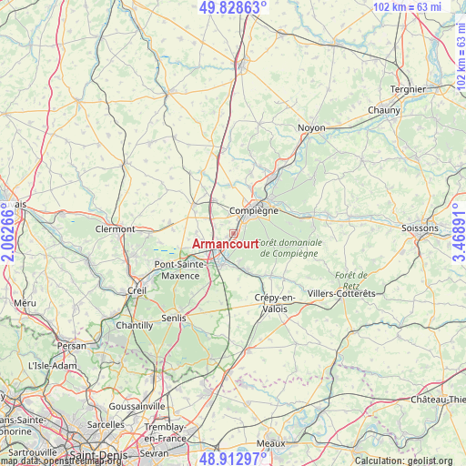
Armancourt GPS coordinates[2]
49° 22' 22.548" North, 2° 45' 56.808" East
| Map corner | latitude | longitude |
|---|---|---|
| Upper-left | 49.82863°, | 2.06266° |
| Center: | 49.37293°, | 2.76578° |
| Lower-right: | 48.91297°, | 3.46891° |
| Map W x H: | 101.8×101.8 km | = 63.3×63.3mi |
| max Lat: | 51.07786° ⇑12.5% North |
| Armancourt: | 49.37293° |
| min Lat: | ⇓87.5% South 41.3874° |
| min Long | Armancourt | max Long |
| -5.08615° | 2.76578° | 9.52242° |
| W 54.4%⇐ | ⇒45.6% E |
Elevation
Elevation of Armancourt is 35 m = 115 ft, and this is 158.7 m = 521 ft below average elevation for this country.
| Max E: |
2333 m = 7654 ft | 87.8% |
| Avg. | 193.7 m = 635 ft | |
| Armancourt | 35 m = 115 ft | |
Min E: |
-1 m = -3 ft | 12.2% |
See also: France elevation on elevation.city.
Geographical zone
Armancourt is located in North temperate zone (between Tropic of Cancer and the Arctic Circle). Distance of this North polar circle is 1911.4 km =1187.7 mi to North.| Distance of | km | miles | from Armancourt |
|---|---|---|---|
| North Pole | 4517.3 | 2806.9 | to North |
| Arctic Circle | 1911.4 | 1187.7 | to North |
| Tropic Cancer | 2883.8 | 1791.9 | to South |
| Equator | 5489.8 | 3411.2 | to South |


Nearby cities:
15 places around Armancourt: (largest is in red/bold)
• Arsy
6.3 km =3.9 mi,  299°
299°
• Canly
4.4 km =2.7 mi,  289°
289°
• Chevrières
6.7 km =4.2 mi,  244°
244°
• Compiègne
6.6 km =4.1 mi,  41°
41°
• Jaux
2.2 km =1.4 mi,  23°
23°
• Jonquières
3.1 km =1.9 mi,  306°
306°
• Lacroix-Saint-Ouen
2.4 km =1.5 mi,  137°
137°
• Le Meux
1.7 km =1.1 mi,  248°
248°
• Longueil-Sainte-Marie
3.8 km =2.4 mi, 243°
• Margny-lès-Compiègne
7 km =4.3 mi,  32°
32°
• Rivecourt
3.6 km =2.2 mi,  218°
218°
• Saint-Sauveur
6.2 km =3.9 mi,  168°
168°
• Saintines
7.2 km =4.5 mi,  180°
180°
• Venette
5.6 km =3.5 mi, 28°
• Verberie
7.3 km =4.5 mi,  199°
199°
Sources, notices
• [Note1] Compared only with cities in France existing in our database
• [Src1] Map data: © OpenStreetMap contributors (CC-BY-SA)
• [Src2] Other city data from geonames.org with taken over terms of usage.
• [Src3] Geographical zone / Annual Mean Temperature by Robert A. Rohde @ Wikipedia
