Cohade geodata
Cohade (Auvergne-Rhône-Alpes) is a populated place; located in France in Europe/Paris (GMT+2) time zone. With population of 739 people, there are 11303 cities with bigger population in this country. Compared to other cities in France, 76% of cities are located further ↑North; 62.9% of cities are located further ←West and 89.4% of cities have lower elevation than Cohade. Note1
Administrative division(s):
- Level 1: Auvergne-Rhône-Alpes
- Level 2: Haute-Loire
- Level 3: Arrondissement de Brioude
- Level 4: Cohade


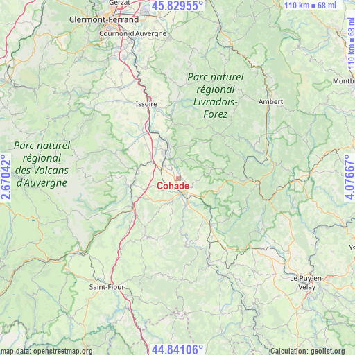
Cohade GPS coordinates[2]
45° 20' 14.856" North, 3° 22' 24.78" East
| Map corner | latitude | longitude |
|---|---|---|
| Upper-left | 45.82955°, | 2.67042° |
| Center: | 45.33746°, | 3.37355° |
| Lower-right: | 44.84106°, | 4.07667° |
| Map W x H: | 109.9×109.9 km | = 68.3×68.3mi |
| max Lat: | 51.07786° ⇑76% North |
| Cohade: | 45.33746° |
| min Lat: | ⇓24% South 41.3874° |
| min Long | Cohade | max Long |
| -5.08615° | 3.37355° | 9.52242° |
| W 62.9%⇐ | ⇒37.1% E |
Elevation
Elevation of Cohade is 414 m = 1358 ft, and this is 220.3 m = 723 ft above average elevation for this country.
| Max E: |
2333 m = 7654 ft | 10.6% |
| Cohade | 414 m 1358 ft | |
| Avg. | 193.7 m = 635 ft | |
Min E: |
-1 m = -3 ft | 89.4% |
See also: France elevation on elevation.city.
Geographical zone
Cohade is located in North temperate zone (between Tropic of Cancer and the Arctic Circle). Distance of this North polar circle is 2360.1 km =1466.5 mi to North.| Distance of | km | miles | from Cohade |
|---|---|---|---|
| North Pole | 4966 | 3085.7 | to North |
| Arctic Circle | 2360.1 | 1466.5 | to North |
| Tropic Cancer | 2435.1 | 1513.1 | to South |
| Equator | 5041.1 | 3132.4 | to South |


Nearby cities:
15 places around Cohade: (largest is in red/bold)
• Auzat-la-Combelle
13.5 km =8.4 mi,  341°
341°
• Auzon
6.1 km =3.8 mi,  359°
359°
• Blesle
16 km =9.9 mi,  262°
262°
• Bournoncle-Saint-Pierre
4.4 km =2.7 mi,  278°
278°
• Brassac-les-Mines
9.2 km =5.7 mi, 337°
• Brioude
4.9 km =3 mi,  170°
170°
• Charbonnier-les-Mines
11.2 km =7 mi,  321°
321°
• Jumeaux
10.7 km =6.6 mi,  345°
345°
• Lamontgie
15.6 km =9.7 mi, 348°
• Lamothe
4.8 km =3 mi,  124°
124°
• Lempdes-sur-Allagnon
8.7 km =5.4 mi,  305°
305°
• Paulhac
4.5 km =2.8 mi,  206°
206°
• Sainte-Florine
8.7 km =5.4 mi,  329°
329°
• Vergongheon
5.6 km =3.5 mi, 311°
• Vieille-Brioude
8.5 km =5.3 mi,  163°
163°
Sources, notices
• [Note1] Compared only with cities in France existing in our database
• [Src1] Map data: © OpenStreetMap contributors (CC-BY-SA)
• [Src2] Other city data from geonames.org with taken over terms of usage.
• [Src3] Geographical zone / Annual Mean Temperature by Robert A. Rohde @ Wikipedia
