Bournoncle-Saint-Pierre geodata
Bournoncle-Saint-Pierre (Auvergne-Rhône-Alpes) is a populated place; located in France in Europe/Paris (GMT+2) time zone. With population of 1,016 people, there are 8720 cities with bigger population in this country. Compared to other cities in France, 75.9% of cities are located further ↑North; 62.3% of cities are located further ←West and 91.5% of cities have lower elevation than Bournoncle-Saint-Pierre. Note1
Administrative division(s):
- Level 1: Auvergne-Rhône-Alpes
- Level 2: Haute-Loire
- Level 3: Arrondissement de Brioude
- Level 4: Bournoncle-Saint-Pierre
Current local time in Bournoncle-Saint-Pierre:
11:32 AM, SaturdayDifference from your time zone: hours


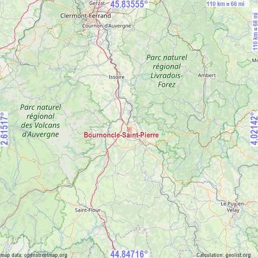
Bournoncle-Saint-Pierre GPS coordinates[2]
45° 20' 36.636" North, 3° 19' 5.88" East
| Map corner | latitude | longitude |
|---|---|---|
| Upper-left | 45.83555°, | 2.61517° |
| Center: | 45.34351°, | 3.3183° |
| Lower-right: | 44.84716°, | 4.02142° |
| Map W x H: | 109.9×109.9 km | = 68.3×68.3mi |
| max Lat: | 51.07786° ⇑75.9% North |
| Bournoncle-Saint-Pierre: | 45.34351° |
| min Lat: | ⇓24.1% South 41.3874° |
| min Long | Bournoncle-Sain | max Long |
| -5.08615° | 3.3183° | 9.52242° |
| W 62.3%⇐ | ⇒37.7% E |
Elevation
Elevation of Bournoncle-Saint-Pierre is 464 m = 1522 ft, and this is 270.3 m = 887 ft above average elevation for this country.
| Max E: |
2333 m = 7654 ft | 8.5% |
| Bournoncle-Saint-Pierre | 464 m 1522 ft | |
| Avg. | 193.7 m = 635 ft | |
Min E: |
-1 m = -3 ft | 91.5% |
See also: France elevation on elevation.city.
Geographical zone
Bournoncle-Saint-Pierre is located in North temperate zone (between Tropic of Cancer and the Arctic Circle). Distance of this North polar circle is 2359.4 km =1466.1 mi to North.| Distance of | km | miles | from Bournoncle-Saint-Pierre |
|---|---|---|---|
| North Pole | 4965.3 | 3085.3 | to North |
| Arctic Circle | 2359.4 | 1466.1 | to North |
| Tropic Cancer | 2435.8 | 1513.5 | to South |
| Equator | 5041.7 | 3132.8 | to South |


Nearby cities:
15 places around Bournoncle-Saint-Pierre: (largest is in red/bold)
• Auzat-la-Combelle
12.1 km =7.5 mi,  359°
359°
• Auzon
6.9 km =4.3 mi,  38°
38°
• Blesle
11.9 km =7.4 mi,  256°
256°
• Brassac-les-Mines
7.9 km =4.9 mi,  6°
6°
• Brioude
7.5 km =4.7 mi,  136°
136°
• Charbonnier-les-Mines
8.5 km =5.3 mi,  342°
342°
• Cohade
4.4 km =2.7 mi,  98°
98°
• Jumeaux
9.9 km =6.2 mi, 9°
• Lamothe
9 km =5.6 mi,  112°
112°
• Lempdes-sur-Allagnon
5.2 km =3.2 mi,  328°
328°
• Massiac
13.9 km =8.6 mi,  222°
222°
• Paulhac
5.3 km =3.3 mi,  153°
153°
• Sainte-Florine
6.9 km =4.3 mi, 359°
• Vergongheon
3.1 km =1.9 mi,  2°
2°
• Vieille-Brioude
11.1 km =6.9 mi, 142°
Sources, notices
• [Note1] Compared only with cities in France existing in our database
• [Src1] Map data: © OpenStreetMap contributors (CC-BY-SA)
• [Src2] Other city data from geonames.org with taken over terms of usage.
• [Src3] Geographical zone / Annual Mean Temperature by Robert A. Rohde @ Wikipedia
