Lamothe geodata
Lamothe (Auvergne-Rhône-Alpes) is a populated place; located in France in Europe/Paris (GMT+2) time zone. With population of 849 people, there are 10089 cities with bigger population in this country. Compared to other cities in France, 76.2% of cities are located further ↑North; 63.5% of cities are located further ←West and 91.2% of cities have lower elevation than Lamothe. Note1
Administrative division(s):
- Level 1: Auvergne-Rhône-Alpes
- Level 2: Haute-Loire
- Level 3: Arrondissement de Brioude
- Level 4: Lamothe


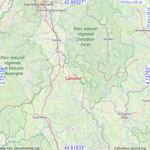
Lamothe GPS coordinates[2]
45° 18' 46.692" North, 3° 25' 28.2" East
| Map corner | latitude | longitude |
|---|---|---|
| Upper-left | 45.80527°, | 2.72138° |
| Center: | 45.31297°, | 3.4245° |
| Lower-right: | 44.81635°, | 4.12763° |
| Map W x H: | 110×110 km | = 68.4×68.4mi |
| max Lat: | 51.07786° ⇑76.2% North |
| Lamothe: | 45.31297° |
| min Lat: | ⇓23.8% South 41.3874° |
| min Long | Lamothe | max Long |
| -5.08615° | 3.4245° | 9.52242° |
| W 63.5%⇐ | ⇒36.5% E |
Elevation
Elevation of Lamothe is 453 m = 1486 ft, and this is 259.3 m = 851 ft above average elevation for this country.
| Max E: |
2333 m = 7654 ft | 8.8% |
| Lamothe | 453 m 1486 ft | |
| Avg. | 193.7 m = 635 ft | |
Min E: |
-1 m = -3 ft | 91.2% |
See also: France elevation on elevation.city.
Geographical zone
Lamothe is located in North temperate zone (between Tropic of Cancer and the Arctic Circle). Distance of this North polar circle is 2362.8 km =1468.2 mi to North.| Distance of | km | miles | from Lamothe |
|---|---|---|---|
| North Pole | 4968.7 | 3087.4 | to North |
| Arctic Circle | 2362.8 | 1468.2 | to North |
| Tropic Cancer | 2432.4 | 1511.4 | to South |
| Equator | 5038.3 | 3130.7 | to South |


Nearby cities:
15 places around Lamothe: (largest is in red/bold)
• Auzat-la-Combelle
17.6 km =10.9 mi,  331°
331°
• Auzon
9.7 km =6 mi,  335°
335°
• Bournoncle-Saint-Pierre
9 km =5.6 mi,  292°
292°
• Brassac-les-Mines
13.5 km =8.4 mi, 326°
• Brioude
3.8 km =2.4 mi,  236°
236°
• Cerzat
17.4 km =10.8 mi,  165°
165°
• Charbonnier-les-Mines
15.9 km =9.9 mi,  316°
316°
• Cohade
4.8 km =3 mi,  304°
304°
• Jumeaux
14.7 km =9.1 mi, 333°
• Lempdes-sur-Allagnon
13.5 km =8.4 mi,  305°
305°
• Paulhac
6.1 km =3.8 mi,  257°
257°
• Paulhaguet
13.6 km =8.5 mi,  149°
149°
• Sainte-Florine
13.2 km =8.2 mi, 320°
• Vergongheon
10.4 km =6.5 mi, 308°
• Vieille-Brioude
5.6 km =3.5 mi,  196°
196°
Sources, notices
• [Note1] Compared only with cities in France existing in our database
• [Src1] Map data: © OpenStreetMap contributors (CC-BY-SA)
• [Src2] Other city data from geonames.org with taken over terms of usage.
• [Src3] Geographical zone / Annual Mean Temperature by Robert A. Rohde @ Wikipedia
