Clémont geodata
Clémont (Centre) is a populated place; located in France in Europe/Paris (GMT+2) time zone. With population of 640 people, there are 12673 cities with bigger population in this country. Compared to other cities in France, 52.3% of cities are located further ↓South; 52.6% of cities are located further →East and 52.5% of cities have lower elevation than Clémont. Note1
Administrative division(s):
- Level 1: Centre
- Level 2: Cher
- Level 3: Arrondissement de Vierzon
- Level 4: Clémont


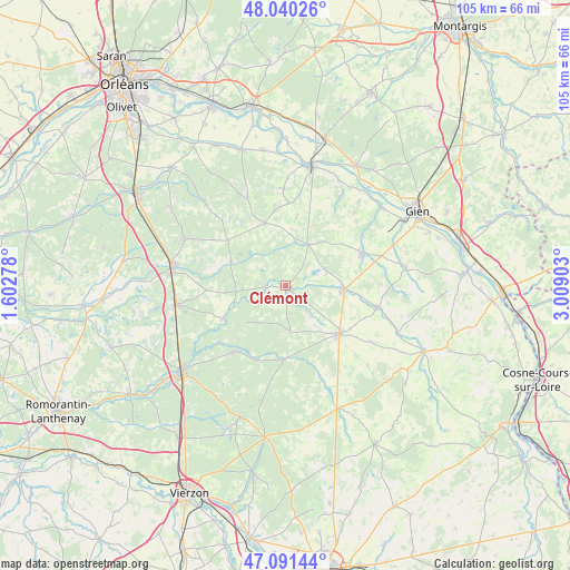
Clémont GPS coordinates[2]
47° 34' 4.8" North, 2° 18' 21.24" East
| Map corner | latitude | longitude |
|---|---|---|
| Upper-left | 48.04026°, | 1.60278° |
| Center: | 47.568°, | 2.3059° |
| Lower-right: | 47.09144°, | 3.00903° |
| Map W x H: | 105.5×105.5 km | = 65.6×65.6mi |
| max Lat: | 51.07786° ⇑47.7% North |
| Clémont: | 47.568° |
| min Lat: | ⇓52.3% South 41.3874° |
| min Long | Clémont | max Long |
| -5.08615° | 2.3059° | 9.52242° |
| W 47.4%⇐ | ⇒52.6% E |
Elevation
Elevation of Clémont is 141 m = 463 ft, and this is 52.7 m = 173 ft below average elevation for this country.
| Max E: |
2333 m = 7654 ft | 47.5% |
| Avg. | 193.7 m = 635 ft | |
| Clémont | 141 m = 463 ft | |
Min E: |
-1 m = -3 ft | 52.5% |
See also: France elevation on elevation.city.
Geographical zone
Clémont is located in North temperate zone (between Tropic of Cancer and the Arctic Circle). Distance of this North polar circle is 2112.1 km =1312.4 mi to North.| Distance of | km | miles | from Clémont |
|---|---|---|---|
| North Pole | 4718 | 2931.6 | to North |
| Arctic Circle | 2112.1 | 1312.4 | to North |
| Tropic Cancer | 2683.1 | 1667.2 | to South |
| Equator | 5289.1 | 3286.5 | to South |


Nearby cities:
15 places around Clémont: (largest is in red/bold)
• Argent-sur-Sauldre
10.4 km =6.5 mi,  95°
95°
• Aubigny-sur-Nère
13.4 km =8.3 mi,  131°
131°
• Blancafort
17.3 km =10.7 mi, 103°
• Brinon-sur-Sauldre
3.7 km =2.3 mi,  266°
266°
• Cerdon
8.7 km =5.4 mi,  29°
29°
• Coullons
15.2 km =9.4 mi,  67°
67°
• Isdes
12.1 km =7.5 mi,  341°
341°
• Nouan-le-Fuzelier
20.5 km =12.7 mi,  260°
260°
• Oizon
18.6 km =11.6 mi,  123°
123°
• Pierrefitte-sur-Sauldre
13.2 km =8.2 mi,  242°
242°
• Sennely
17.1 km =10.6 mi,  315°
315°
• Souesmes
15.8 km =9.8 mi,  218°
218°
• Vannes-sur-Cosson
17.6 km =10.9 mi, 336°
• Viglain
17.8 km =11.1 mi,  359°
359°
• Villemurlin
13.3 km =8.3 mi,  9°
9°
Sources, notices
• [Note1] Compared only with cities in France existing in our database
• [Src1] Map data: © OpenStreetMap contributors (CC-BY-SA)
• [Src2] Other city data from geonames.org with taken over terms of usage.
• [Src3] Geographical zone / Annual Mean Temperature by Robert A. Rohde @ Wikipedia
