Nouan-le-Fuzelier geodata
Nouan-le-Fuzelier (Centre) is a populated place; located in France in Europe/Paris (GMT+2) time zone. With population of 2,469 people, there are 3933 cities with bigger population in this country. Compared to other cities in France, 51.8% of cities are located further ↓South; 56.7% of cities are located further →East and 56.5% of cities have higher elevation than Nouan-le-Fuzelier. Note1
Administrative division(s):
- Level 1: Centre
- Level 2: Département du Loir-et-Cher
- Level 3: Arrondissement de Romorantin-Lanthenay
- Level 4: Nouan-le-Fuzelier


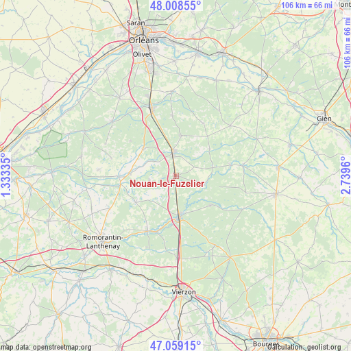
Nouan-le-Fuzelier GPS coordinates[2]
47° 32' 9.6" North, 2° 2' 11.292" East
| Map corner | latitude | longitude |
|---|---|---|
| Upper-left | 48.00855°, | 1.33335° |
| Center: | 47.536°, | 2.03647° |
| Lower-right: | 47.05915°, | 2.7396° |
| Map W x H: | 105.6×105.6 km | = 65.6×65.6mi |
| max Lat: | 51.07786° ⇑48.2% North |
| Nouan-le-Fuzelier: | 47.536° |
| min Lat: | ⇓51.8% South 41.3874° |
| min Long | Nouan-le-Fuzeli | max Long |
| -5.08615° | 2.03647° | 9.52242° |
| W 43.3%⇐ | ⇒56.7% E |
Elevation
Elevation of Nouan-le-Fuzelier is 112 m = 367 ft, and this is 81.7 m = 268 ft below average elevation for this country.
| Max E: |
2333 m = 7654 ft | 56.5% |
| Avg. | 193.7 m = 635 ft | |
| Nouan-le-Fuzelier | 112 m = 367 ft | |
Min E: |
-1 m = -3 ft | 43.5% |
See also: France elevation on elevation.city.
Geographical zone
Nouan-le-Fuzelier is located in North temperate zone (between Tropic of Cancer and the Arctic Circle). Distance of this North polar circle is 2115.7 km =1314.6 mi to North.| Distance of | km | miles | from Nouan-le-Fuzelier |
|---|---|---|---|
| North Pole | 4721.6 | 2933.9 | to North |
| Arctic Circle | 2115.7 | 1314.6 | to North |
| Tropic Cancer | 2679.6 | 1665 | to South |
| Equator | 5285.5 | 3284.3 | to South |


Nearby cities:
15 places around Nouan-le-Fuzelier: (largest is in red/bold)
• Brinon-sur-Sauldre
16.8 km =10.4 mi,  78°
78°
• Chaumont-sur-Tharonne
12.9 km =8 mi,  310°
310°
• La Ferté-Beauharnais
14 km =8.7 mi,  272°
272°
• La Ferté-Imbault
17.9 km =11.1 mi,  200°
200°
• Lamotte-Beuvron
7.4 km =4.6 mi,  355°
355°
• Marcilly-en-Gault
14.5 km =9 mi,  237°
237°
• Ménestreau-en-Villette
18.2 km =11.3 mi, 356°
• Neung-sur-Beuvron
17.4 km =10.8 mi, 269°
• Pierrefitte-sur-Sauldre
8.9 km =5.5 mi,  107°
107°
• Saint-Viâtre
7.9 km =4.9 mi,  260°
260°
• Salbris
12.5 km =7.8 mi,  174°
174°
• Sennely
17.9 km =11.1 mi,  27°
27°
• Souesmes
13.7 km =8.5 mi,  130°
130°
• Vouzon
12.2 km =7.6 mi,  6°
6°
• Yvoy-le-Marron
17.4 km =10.8 mi, 307°
Sources, notices
• [Note1] Compared only with cities in France existing in our database
• [Src1] Map data: © OpenStreetMap contributors (CC-BY-SA)
• [Src2] Other city data from geonames.org with taken over terms of usage.
• [Src3] Geographical zone / Annual Mean Temperature by Robert A. Rohde @ Wikipedia
