Chéreng geodata
Chéreng (Hauts-de-France) is a populated place; located in France in Europe/Paris (GMT+2) time zone. With population of 2,988 people, there are 3263 cities with bigger population in this country. Compared to other cities in France, 98.2% of cities are located further ↓South; 60.7% of cities are located further ←West and 87.8% of cities have higher elevation than Chéreng. Note1
Administrative division(s):
- Level 1: Hauts-de-France
- Level 2: Nord
- Level 3: Arrondissement de Lille
- Level 4: Chéreng


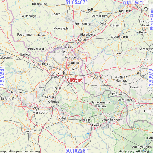
Chéreng GPS coordinates[2]
50° 36' 38.124" North, 3° 12' 23.976" East
| Map corner | latitude | longitude |
|---|---|---|
| Upper-left | 51.05467°, | 2.50354° |
| Center: | 50.61059°, | 3.20666° |
| Lower-right: | 50.16228°, | 3.90979° |
| Map W x H: | 99.2×99.2 km | = 61.6×61.6mi |
| max Lat: | 51.07786° ⇑1.8% North |
| Chéreng: | 50.61059° |
| min Lat: | ⇓98.2% South 41.3874° |
| min Long | Chéreng | max Long |
| -5.08615° | 3.20666° | 9.52242° |
| W 60.7%⇐ | ⇒39.3% E |
Elevation
Elevation of Chéreng is 35 m = 115 ft, and this is 158.7 m = 521 ft below average elevation for this country.
| Max E: |
2333 m = 7654 ft | 87.8% |
| Avg. | 193.7 m = 635 ft | |
| Chéreng | 35 m = 115 ft | |
Min E: |
-1 m = -3 ft | 12.2% |
See also: France elevation on elevation.city.
Geographical zone
Chéreng is located in North temperate zone (between Tropic of Cancer and the Arctic Circle). Distance of this North polar circle is 1773.8 km =1102.2 mi to North.| Distance of | km | miles | from Chéreng |
|---|---|---|---|
| North Pole | 4379.7 | 2721.4 | to North |
| Arctic Circle | 1773.8 | 1102.2 | to North |
| Tropic Cancer | 3021.5 | 1877.5 | to South |
| Equator | 5627.4 | 3496.7 | to South |


Nearby cities:
15 places around Chéreng: (largest is in red/bold)
• Anstaing
1.3 km =0.8 mi,  239°
239°
• Baisieux
3.2 km =2 mi,  94°
94°
• Bourghelles
5.7 km =3.5 mi,  152°
152°
• Bouvines
3.8 km =2.4 mi,  199°
199°
• Camphin-en-Pévèle
4.2 km =2.6 mi,  113°
113°
• Cysoing
4.6 km =2.9 mi,  171°
171°
• Forest-sur-Marque
2.8 km =1.7 mi,  334°
334°
• Gruson
1.6 km =1 mi,  177°
177°
• Hem
4.9 km =3 mi,  343°
343°
• Péronne-en-Mélantois
5.4 km =3.4 mi,  209°
209°
• Sailly-lez-Lannoy
4.4 km =2.7 mi,  9°
9°
• Sainghin-en-Mélantois
3.8 km =2.4 mi,  229°
229°
• Tressin
1.2 km =0.7 mi,  309°
309°
• Villeneuve-d'Ascq
2.9 km =1.8 mi,  283°
283°
• Willems
3.3 km =2.1 mi,  43°
43°
Sources, notices
• [Note1] Compared only with cities in France existing in our database
• [Src1] Map data: © OpenStreetMap contributors (CC-BY-SA)
• [Src2] Other city data from geonames.org with taken over terms of usage.
• [Src3] Geographical zone / Annual Mean Temperature by Robert A. Rohde @ Wikipedia
