Hem geodata
Hem (Hauts-de-France) is a populated place; located in France in Europe/Paris (GMT+2) time zone. With population of 19,699 people, there are 469 cities with bigger population in this country. Compared to other cities in France, 98.5% of cities are located further ↓South; 60.4% of cities are located further ←West and 89.5% of cities have higher elevation than Hem. Note1
Administrative division(s):
- Level 1: Hauts-de-France
- Level 2: Nord
- Level 3: Arrondissement de Lille
- Level 4: Hem


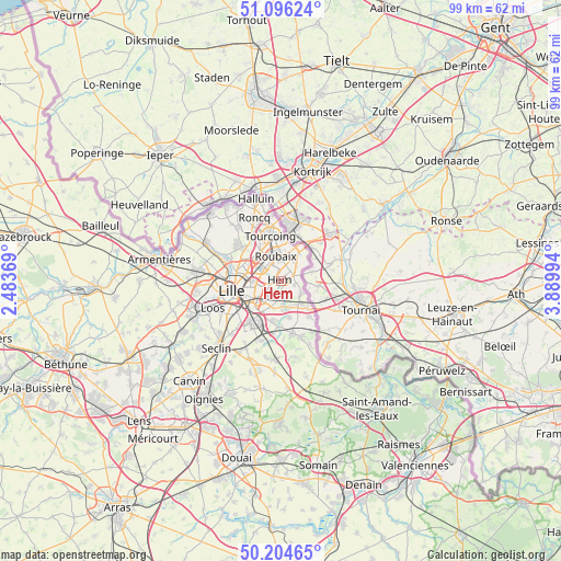
Hem GPS coordinates[2]
50° 39' 9.216" North, 3° 11' 12.516" East
| Map corner | latitude | longitude |
|---|---|---|
| Upper-left | 51.09624°, | 2.48369° |
| Center: | 50.65256°, | 3.18681° |
| Lower-right: | 50.20465°, | 3.88994° |
| Map W x H: | 99.1×99.1 km | = 61.6×61.6mi |
| max Lat: | 51.07786° ⇑1.5% North |
| Hem: | 50.65256° |
| min Lat: | ⇓98.5% South 41.3874° |
| min Long | Hem | max Long |
| -5.08615° | 3.18681° | 9.52242° |
| W 60.4%⇐ | ⇒39.6% E |
Elevation
Elevation of Hem is 31 m = 102 ft, and this is 162.7 m = 534 ft below average elevation for this country.
| Max E: |
2333 m = 7654 ft | 89.5% |
| Avg. | 193.7 m = 635 ft | |
| Hem | 31 m = 102 ft | |
Min E: |
-1 m = -3 ft | 10.5% |
See also: France elevation on elevation.city.
Geographical zone
Hem is located in North temperate zone (between Tropic of Cancer and the Arctic Circle). Distance of this North polar circle is 1769.1 km =1099.3 mi to North.| Distance of | km | miles | from Hem |
|---|---|---|---|
| North Pole | 4375 | 2718.5 | to North |
| Arctic Circle | 1769.1 | 1099.3 | to North |
| Tropic Cancer | 3026.1 | 1880.3 | to South |
| Equator | 5632 | 3499.6 | to South |


Nearby cities:
15 places around Hem: (largest is in red/bold)
• Anstaing
5.3 km =3.3 mi,  176°
176°
• Chéreng
4.9 km =3 mi,  163°
163°
• Croix
3.9 km =2.4 mi,  317°
317°
• Forest-sur-Marque
2.1 km =1.3 mi, 175°
• Lannoy
2.3 km =1.4 mi,  46°
46°
• Leers
5.2 km =3.2 mi, 50°
• Lys-lez-Lannoy
2.6 km =1.6 mi, 53°
• Mons-en-Barœul
5.4 km =3.4 mi,  246°
246°
• Roubaix
4.7 km =2.9 mi,  349°
349°
• Sailly-lez-Lannoy
2.1 km =1.3 mi,  97°
97°
• Toufflers
3.4 km =2.1 mi,  75°
75°
• Tressin
3.9 km =2.4 mi,  173°
173°
• Villeneuve-d'Ascq
4.2 km =2.6 mi,  199°
199°
• Wasquehal
4.2 km =2.6 mi,  298°
298°
• Willems
4.3 km =2.7 mi,  122°
122°
Sources, notices
• [Note1] Compared only with cities in France existing in our database
• [Src1] Map data: © OpenStreetMap contributors (CC-BY-SA)
• [Src2] Other city data from geonames.org with taken over terms of usage.
• [Src3] Geographical zone / Annual Mean Temperature by Robert A. Rohde @ Wikipedia
