Villeneuve-d'Ascq geodata
Villeneuve-d'Ascq (Hauts-de-France) is a populated place; located in France in Europe/Paris (GMT+2) time zone. With population of 62,400 people, there are 76 cities with bigger population in this country. Compared to other cities in France, 98.2% of cities are located further ↓South; 60.1% of cities are located further ←West and 89.1% of cities have higher elevation than Villeneuve-d'Ascq. Note1
Administrative division(s):
- Level 1: Hauts-de-France
- Level 2: Nord
- Level 3: Arrondissement de Lille
- Level 4: Villeneuve-d'Ascq


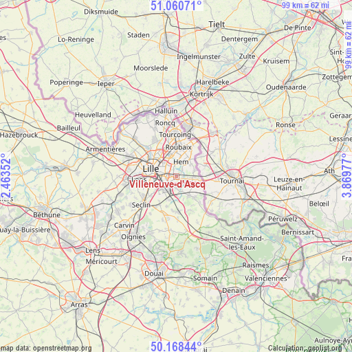
Villeneuve-d'Ascq GPS coordinates[2]
50° 37' 0.084" North, 3° 9' 59.904" East
| Map corner | latitude | longitude |
|---|---|---|
| Upper-left | 51.06071°, | 2.46352° |
| Center: | 50.61669°, | 3.16664° |
| Lower-right: | 50.16844°, | 3.86977° |
| Map W x H: | 99.2×99.2 km | = 61.6×61.6mi |
| max Lat: | 51.07786° ⇑1.8% North |
| Villeneuve-d'Ascq: | 50.61669° |
| min Lat: | ⇓98.2% South 41.3874° |
| min Long | Villeneuve-d'As | max Long |
| -5.08615° | 3.16664° | 9.52242° |
| W 60.1%⇐ | ⇒39.9% E |
Elevation
Elevation of Villeneuve-d'Ascq is 32 m = 105 ft, and this is 161.7 m = 531 ft below average elevation for this country.
| Max E: |
2333 m = 7654 ft | 89.1% |
| Avg. | 193.7 m = 635 ft | |
| Villeneuve-d'Ascq | 32 m = 105 ft | |
Min E: |
-1 m = -3 ft | 10.9% |
See also: Villeneuve-d'Ascq elevation on elevation.city.
Geographical zone
Villeneuve-d'Ascq is located in North temperate zone (between Tropic of Cancer and the Arctic Circle). Distance of this North polar circle is 1773.1 km =1101.8 mi to North.| Distance of | km | miles | from Villeneuve-d'Ascq |
|---|---|---|---|
| North Pole | 4379 | 2721 | to North |
| Arctic Circle | 1773.1 | 1101.8 | to North |
| Tropic Cancer | 3022.1 | 1877.8 | to South |
| Equator | 5628 | 3497.1 | to South |


Nearby cities:
15 places around Villeneuve-d'Ascq: (largest is in red/bold)
• Anstaing
2.2 km =1.4 mi,  127°
127°
• Bouvines
4.5 km =2.8 mi,  159°
159°
• Chéreng
2.9 km =1.8 mi,  103°
103°
• Forest-sur-Marque
2.5 km =1.6 mi,  40°
40°
• Gruson
3.7 km =2.3 mi, 128°
• Hem
4.2 km =2.6 mi,  19°
19°
• Lesquin
5.1 km =3.2 mi,  221°
221°
• Lezennes
3.7 km =2.3 mi,  268°
268°
• Mons-en-Barœul
4 km =2.5 mi,  297°
297°
• Péronne-en-Mélantois
5.4 km =3.4 mi,  178°
178°
• Ronchin
5.7 km =3.5 mi,  249°
249°
• Sailly-lez-Lannoy
5.1 km =3.2 mi, 43°
• Sainghin-en-Mélantois
3.2 km =2 mi, 180°
• Tressin
1.9 km =1.2 mi,  87°
87°
• Willems
5.3 km =3.3 mi,  71°
71°
Sources, notices
• [Note1] Compared only with cities in France existing in our database
• [Src1] Map data: © OpenStreetMap contributors (CC-BY-SA)
• [Src2] Other city data from geonames.org with taken over terms of usage.
• [Src3] Geographical zone / Annual Mean Temperature by Robert A. Rohde @ Wikipedia
