Châtonnay geodata
Châtonnay (Auvergne-Rhône-Alpes) is a populated place; located in France in Europe/Paris (GMT+2) time zone. With population of 1,716 people, there are 5477 cities with bigger population in this country. Compared to other cities in France, 74.3% of cities are located further ↑North; 79.9% of cities are located further ←West and 92.5% of cities have lower elevation than Châtonnay. Note1
Administrative division(s):
- Level 1: Auvergne-Rhône-Alpes
- Level 2: Département de l'Isère
- Level 3: Arrondissement de Vienne
- Level 4: Châtonnay


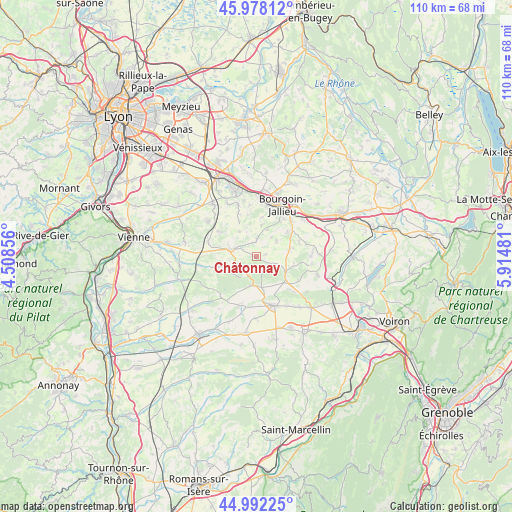
Châtonnay GPS coordinates[2]
45° 29' 14.424" North, 5° 12' 42.048" East
| Map corner | latitude | longitude |
|---|---|---|
| Upper-left | 45.97812°, | 4.50856° |
| Center: | 45.48734°, | 5.21168° |
| Lower-right: | 44.99225°, | 5.91481° |
| Map W x H: | 109.6×109.6 km | = 68.1×68.1mi |
| max Lat: | 51.07786° ⇑74.3% North |
| Châtonnay: | 45.48734° |
| min Lat: | ⇓25.7% South 41.3874° |
| min Long | Châtonnay | max Long |
| -5.08615° | 5.21168° | 9.52242° |
| W 79.9%⇐ | ⇒20.1% E |
Elevation
Elevation of Châtonnay is 488 m = 1601 ft, and this is 294.3 m = 966 ft above average elevation for this country.
| Max E: |
2333 m = 7654 ft | 7.5% |
| Châtonnay | 488 m 1601 ft | |
| Avg. | 193.7 m = 635 ft | |
Min E: |
-1 m = -3 ft | 92.5% |
See also: France elevation on elevation.city.
Geographical zone
Châtonnay is located in North temperate zone (between Tropic of Cancer and the Arctic Circle). Distance of this North polar circle is 2343.5 km =1456.2 mi to North.| Distance of | km | miles | from Châtonnay |
|---|---|---|---|
| North Pole | 4949.3 | 3075.4 | to North |
| Arctic Circle | 2343.5 | 1456.2 | to North |
| Tropic Cancer | 2451.8 | 1523.5 | to South |
| Equator | 5057.7 | 3142.7 | to South |


Nearby cities:
15 places around Châtonnay: (largest is in red/bold)
• Artas
6.7 km =4.2 mi,  325°
325°
• Badinières
7.5 km =4.7 mi,  72°
72°
• Champier
7.2 km =4.5 mi,  119°
119°
• Charantonnay
9.7 km =6 mi,  304°
304°
• Châteauvilain
9.7 km =6 mi, 71°
• Commelle
6.7 km =4.2 mi,  170°
170°
• Culin
5.2 km =3.2 mi,  37°
37°
• Eclose
7 km =4.3 mi,  79°
79°
• Les Éparres
8.5 km =5.3 mi,  50°
50°
• Maubec
9.8 km =6.1 mi,  24°
24°
• Meyrieu-les-Étangs
3.4 km =2.1 mi,  344°
344°
• Saint-Agnin-sur-Bion
6.1 km =3.8 mi, 18°
• Saint-Jean-de-Bournay
5.9 km =3.7 mi,  284°
284°
• Tramolé
5.6 km =3.5 mi, 52°
• Villeneuve-de-Marc
8.7 km =5.4 mi,  262°
262°
Sources, notices
• [Note1] Compared only with cities in France existing in our database
• [Src1] Map data: © OpenStreetMap contributors (CC-BY-SA)
• [Src2] Other city data from geonames.org with taken over terms of usage.
• [Src3] Geographical zone / Annual Mean Temperature by Robert A. Rohde @ Wikipedia
