Châtillon-sur-Chalaronne geodata
Châtillon-sur-Chalaronne (Auvergne-Rhône-Alpes) is a populated place; located in France in Europe/Paris (GMT+2) time zone. With population of 4,660 people, there are 2122 cities with bigger population in this country. Compared to other cities in France, 64.8% of cities are located further ↑North; 77.2% of cities are located further ←West and 74% of cities have lower elevation than Châtillon-sur-Chalaronne. Note1
Administrative division(s):
- Level 1: Auvergne-Rhône-Alpes
- Level 2: Département de l'Ain
- Level 3: Arrondissement de Bourg-en-Bresse
- Level 4: Châtillon-sur-Chalaronne
Current local time in Châtillon-sur-Chalaronne:
05:54 PM, SaturdayDifference from your time zone: hours


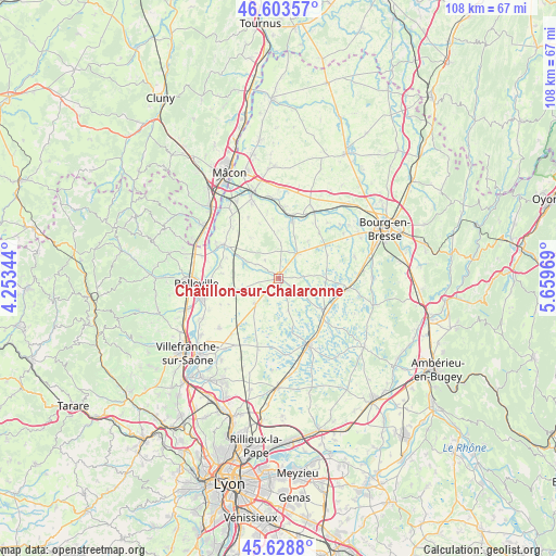
Châtillon-sur-Chalaronne GPS coordinates[2]
46° 7' 6.024" North, 4° 57' 23.616" East
| Map corner | latitude | longitude |
|---|---|---|
| Upper-left | 46.60357°, | 4.25344° |
| Center: | 46.11834°, | 4.95656° |
| Lower-right: | 45.6288°, | 5.65969° |
| Map W x H: | 108.4×108.4 km | = 67.4×67.4mi |
| max Lat: | 51.07786° ⇑64.8% North |
| Châtillon-sur-Chalaronne: | 46.11834° |
| min Lat: | ⇓35.2% South 41.3874° |
| min Long | Châtillon-sur- | max Long |
| -5.08615° | 4.95656° | 9.52242° |
| W 77.2%⇐ | ⇒22.8% E |
Elevation
Elevation of Châtillon-sur-Chalaronne is 242 m = 794 ft, and this is 48.3 m = 158 ft above average elevation for this country.
| Max E: |
2333 m = 7654 ft | 26% |
| Châtillon-sur-Chalaronne | 242 m 794 ft | |
| Avg. | 193.7 m = 635 ft | |
Min E: |
-1 m = -3 ft | 74% |
See also: France elevation on elevation.city.
Geographical zone
Châtillon-sur-Chalaronne is located in North temperate zone (between Tropic of Cancer and the Arctic Circle). Distance of this North polar circle is 2273.3 km =1412.6 mi to North.| Distance of | km | miles | from Châtillon-sur-Chalaronne |
|---|---|---|---|
| North Pole | 4879.2 | 3031.8 | to North |
| Arctic Circle | 2273.3 | 1412.6 | to North |
| Tropic Cancer | 2522 | 1567.1 | to South |
| Equator | 5127.9 | 3186.3 | to South |


Nearby cities:
15 places around Châtillon-sur-Chalaronne: (largest is in red/bold)
• Baneins
4.2 km =2.6 mi,  258°
258°
• Biziat
11.1 km =6.9 mi,  354°
354°
• Chaneins
8.3 km =5.2 mi,  253°
253°
• Chanoz-Châtenay
9.4 km =5.8 mi,  37°
37°
• Condeissiat
10.4 km =6.5 mi,  65°
65°
• Illiat
9.6 km =6 mi,  324°
324°
• Marlieux
10.7 km =6.6 mi,  123°
123°
• Mogneneins
11.5 km =7.1 mi,  281°
281°
• Neuville-les-Dames
6.2 km =3.9 mi, 38°
• Romans
5.3 km =3.3 mi,  88°
88°
• Saint-Julien-sur-Veyle
9.1 km =5.7 mi,  359°
359°
• Saint-Trivier-sur-Moignans
6.9 km =4.3 mi,  221°
221°
• Saint-Étienne-sur-Chalaronne
7.3 km =4.5 mi,  296°
296°
• Sulignat
6.1 km =3.8 mi,  2°
2°
• Vonnas
11.3 km =7 mi,  14°
14°
Sources, notices
• [Note1] Compared only with cities in France existing in our database
• [Src1] Map data: © OpenStreetMap contributors (CC-BY-SA)
• [Src2] Other city data from geonames.org with taken over terms of usage.
• [Src3] Geographical zone / Annual Mean Temperature by Robert A. Rohde @ Wikipedia
