Mogneneins geodata
Mogneneins (Auvergne-Rhône-Alpes) is a populated place; located in France in Europe/Paris (GMT+2) time zone. With population of 645 people, there are 12593 cities with bigger population in this country. Compared to other cities in France, 64.5% of cities are located further ↑North; 75.2% of cities are located further ←West and 70.4% of cities have lower elevation than Mogneneins. Note1
Administrative division(s):
- Level 1: Auvergne-Rhône-Alpes
- Level 2: Département de l'Ain
- Level 3: Arrondissement de Bourg-en-Bresse
- Level 4: Mogneneins


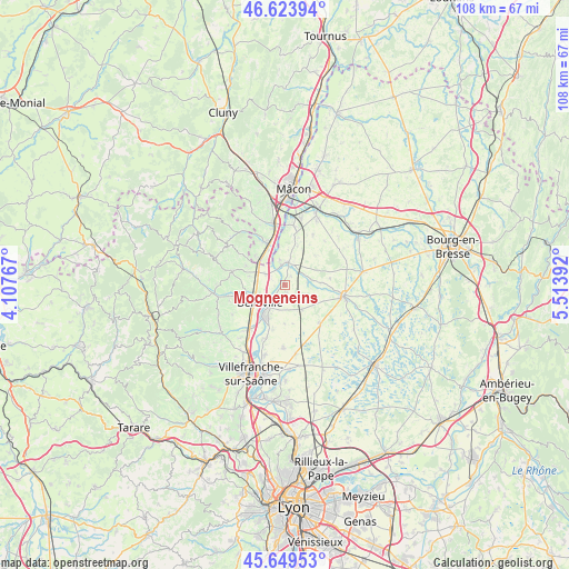
Mogneneins GPS coordinates[2]
46° 8' 20.004" North, 4° 48' 38.88" East
| Map corner | latitude | longitude |
|---|---|---|
| Upper-left | 46.62394°, | 4.10767° |
| Center: | 46.13889°, | 4.8108° |
| Lower-right: | 45.64953°, | 5.51392° |
| Map W x H: | 108.3×108.3 km | = 67.3×67.3mi |
| max Lat: | 51.07786° ⇑64.5% North |
| Mogneneins: | 46.13889° |
| min Lat: | ⇓35.5% South 41.3874° |
| min Long | Mogneneins | max Long |
| -5.08615° | 4.8108° | 9.52242° |
| W 75.2%⇐ | ⇒24.8% E |
Elevation
Elevation of Mogneneins is 221 m = 725 ft, and this is 27.3 m = 90 ft above average elevation for this country.
| Max E: |
2333 m = 7654 ft | 29.6% |
| Mogneneins | 221 m 725 ft | |
| Avg. | 193.7 m = 635 ft | |
Min E: |
-1 m = -3 ft | 70.4% |
See also: France elevation on elevation.city.
Geographical zone
Mogneneins is located in North temperate zone (between Tropic of Cancer and the Arctic Circle). Distance of this North polar circle is 2271 km =1411.1 mi to North.| Distance of | km | miles | from Mogneneins |
|---|---|---|---|
| North Pole | 4876.9 | 3030.4 | to North |
| Arctic Circle | 2271 | 1411.1 | to North |
| Tropic Cancer | 2524.2 | 1568.5 | to South |
| Equator | 5130.2 | 3187.8 | to South |


Nearby cities:
15 places around Mogneneins: (largest is in red/bold)
• Baneins
7.8 km =4.8 mi,  113°
113°
• Belleville
5.8 km =3.6 mi,  234°
234°
• Chaneins
5.7 km =3.5 mi,  145°
145°
• Corcelles-en-Beaujolais
6.9 km =4.3 mi,  284°
284°
• Dracé
4 km =2.5 mi,  299°
299°
• Francheleins
7.2 km =4.5 mi,  180°
180°
• Guéreins
4.9 km =3 mi,  216°
216°
• Illiat
7.9 km =4.9 mi,  45°
45°
• Montceaux
4.9 km =3 mi,  192°
192°
• Montmerle-sur-Saône
7.1 km =4.4 mi,  208°
208°
• Romanèche-Thorins
7.3 km =4.5 mi,  313°
313°
• Saint-Didier-sur-Chalaronne
4.3 km =2.7 mi,  5°
5°
• Saint-Étienne-sur-Chalaronne
4.8 km =3 mi,  78°
78°
• Taponas
3.9 km =2.4 mi,  240°
240°
• Thoissey
3.8 km =2.4 mi,  350°
350°
Sources, notices
• [Note1] Compared only with cities in France existing in our database
• [Src1] Map data: © OpenStreetMap contributors (CC-BY-SA)
• [Src2] Other city data from geonames.org with taken over terms of usage.
• [Src3] Geographical zone / Annual Mean Temperature by Robert A. Rohde @ Wikipedia
