Saint-Julien-sur-Veyle geodata
Saint-Julien-sur-Veyle (Auvergne-Rhône-Alpes) is a populated place; located in France in Europe/Paris (GMT+2) time zone. With population of 580 people, there are 13652 cities with bigger population in this country. Compared to other cities in France, 63.6% of cities are located further ↑North; 77.2% of cities are located further ←West and 67.4% of cities have lower elevation than Saint-Julien-sur-Veyle. Note1
Administrative division(s):
- Level 1: Auvergne-Rhône-Alpes
- Level 2: Département de l'Ain
- Level 3: Arrondissement de Bourg-en-Bresse
- Level 4: Saint-Julien-sur-Veyle
Current local time in Saint-Julien-sur-Veyle:
07:23 PM, SaturdayDifference from your time zone: hours


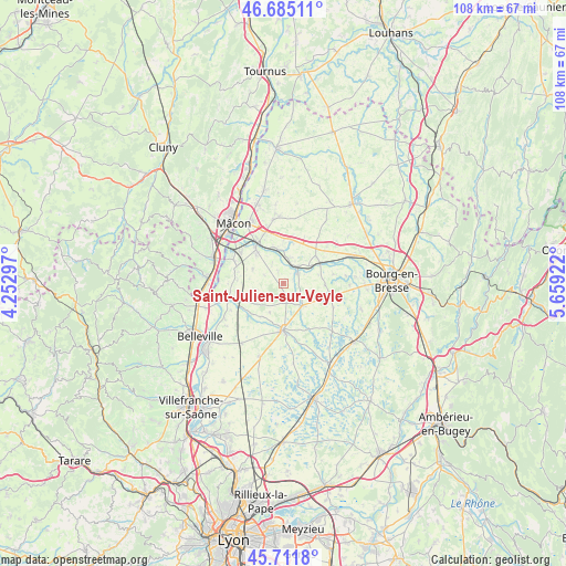
Saint-Julien-sur-Veyle GPS coordinates[2]
46° 12' 2.196" North, 4° 57' 21.96" East
| Map corner | latitude | longitude |
|---|---|---|
| Upper-left | 46.68511°, | 4.25297° |
| Center: | 46.20061°, | 4.9561° |
| Lower-right: | 45.7118°, | 5.65922° |
| Map W x H: | 108.2×108.2 km | = 67.2×67.2mi |
| max Lat: | 51.07786° ⇑63.6% North |
| Saint-Julien-sur-Veyle: | 46.20061° |
| min Lat: | ⇓36.4% South 41.3874° |
| min Long | Saint-Julien-su | max Long |
| -5.08615° | 4.9561° | 9.52242° |
| W 77.2%⇐ | ⇒22.8% E |
Elevation
Elevation of Saint-Julien-sur-Veyle is 206 m = 676 ft, and this is 12.3 m = 40 ft above average elevation for this country.
| Max E: |
2333 m = 7654 ft | 32.6% |
| Saint-Julien-sur-Veyle | 206 m 676 ft | |
| Avg. | 193.7 m = 635 ft | |
Min E: |
-1 m = -3 ft | 67.4% |
See also: France elevation on elevation.city.
Geographical zone
Saint-Julien-sur-Veyle is located in North temperate zone (between Tropic of Cancer and the Arctic Circle). Distance of this North polar circle is 2264.1 km =1406.8 mi to North.| Distance of | km | miles | from Saint-Julien-sur-Veyle |
|---|---|---|---|
| North Pole | 4870 | 3026.1 | to North |
| Arctic Circle | 2264.1 | 1406.8 | to North |
| Tropic Cancer | 2531.1 | 1572.8 | to South |
| Equator | 5137 | 3192 | to South |


Nearby cities:
15 places around Saint-Julien-sur-Veyle: (largest is in red/bold)
• Biziat
2.1 km =1.3 mi,  331°
331°
• Chanoz-Châtenay
6.1 km =3.8 mi,  106°
106°
• Chaveyriat
8 km =5 mi,  92°
92°
• Cruzilles-lès-Mépillat
6.5 km =4 mi,  294°
294°
• Illiat
5.7 km =3.5 mi,  256°
256°
• Laiz
7.6 km =4.7 mi,  317°
317°
• Mézériat
8 km =5 mi,  59°
59°
• Neuville-les-Dames
5.8 km =3.6 mi,  137°
137°
• Perrex
5.2 km =3.2 mi,  17°
17°
• Pont-de-Veyle
8.7 km =5.4 mi, 321°
• Saint-Cyr-sur-Menthon
8.4 km =5.2 mi,  8°
8°
• Saint-Jean-sur-Veyle
7.2 km =4.5 mi,  335°
335°
• Saint-Étienne-sur-Chalaronne
8.8 km =5.5 mi,  228°
228°
• Sulignat
3.1 km =1.9 mi,  174°
174°
• Vonnas
3.4 km =2.1 mi, 56°
Sources, notices
• [Note1] Compared only with cities in France existing in our database
• [Src1] Map data: © OpenStreetMap contributors (CC-BY-SA)
• [Src2] Other city data from geonames.org with taken over terms of usage.
• [Src3] Geographical zone / Annual Mean Temperature by Robert A. Rohde @ Wikipedia
