Châteaubernard geodata
Châteaubernard (Nouvelle-Aquitaine) is a populated place; located in France in Europe/Paris (GMT+2) time zone. With population of 3,890 people, there are 2525 cities with bigger population in this country. Compared to other cities in France, 71.5% of cities are located further ↑North; 81.3% of cities are located further →East and 94.4% of cities have higher elevation than Châteaubernard. Note1
Administrative division(s):
- Level 1: Nouvelle-Aquitaine
- Level 2: Charente
- Level 3: Arrondissement de Cognac
- Level 4: Châteaubernard


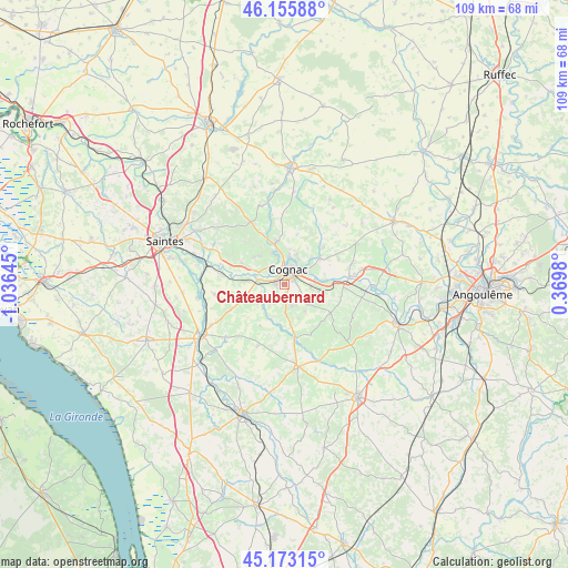
Châteaubernard GPS coordinates[2]
45° 40' 0.012" North, 0° 19' 59.988" West
| Map corner | latitude | longitude |
|---|---|---|
| Upper-left | 46.15588°, | -1.03645° |
| Center: | 45.66667°, | -0.33333° |
| Lower-right: | 45.17315°, | 0.3698° |
| Map W x H: | 109.3×109.3 km | = 67.9×67.9mi |
| max Lat: | 51.07786° ⇑71.5% North |
| Châteaubernard: | 45.66667° |
| min Lat: | ⇓28.5% South 41.3874° |
| min Long | Châteaubernard | max Long |
| -5.08615° | -0.33333° | 9.52242° |
| W 18.7%⇐ | ⇒81.3% E |
Elevation
Elevation of Châteaubernard is 19 m = 62 ft, and this is 174.7 m = 573 ft below average elevation for this country.
| Max E: |
2333 m = 7654 ft | 94.4% |
| Avg. | 193.7 m = 635 ft | |
| Châteaubernard | 19 m = 62 ft | |
Min E: |
-1 m = -3 ft | 5.6% |
See also: France elevation on elevation.city.
Geographical zone
Châteaubernard is located in North temperate zone (between Tropic of Cancer and the Arctic Circle). Distance of this North polar circle is 2323.5 km =1443.8 mi to North.| Distance of | km | miles | from Châteaubernard |
|---|---|---|---|
| North Pole | 4929.4 | 3063 | to North |
| Arctic Circle | 2323.5 | 1443.8 | to North |
| Tropic Cancer | 2471.7 | 1535.8 | to South |
| Equator | 5077.7 | 3155.1 | to South |


Nearby cities:
15 places around Châteaubernard: (largest is in red/bold)
• Angeac-Champagne
7.9 km =4.9 mi,  160°
160°
• Ars
4.6 km =2.9 mi,  235°
235°
• Bourg-Charente
7.8 km =4.8 mi,  90°
90°
• Boutiers-Saint-Trojan
6.1 km =3.8 mi,  24°
24°
• Cherves-Richemont
8.6 km =5.3 mi,  350°
350°
• Cognac
3.3 km =2.1 mi,  5°
5°
• Gensac-la-Pallue
6.7 km =4.2 mi,  105°
105°
• Genté
5.7 km =3.5 mi,  166°
166°
• Gimeux
4.4 km =2.7 mi,  218°
218°
• Javrezac
3.9 km =2.4 mi,  340°
340°
• Merpins
5.5 km =3.4 mi,  289°
289°
• Nercillac
8.5 km =5.3 mi,  49°
49°
• Saint-Brice
4.3 km =2.7 mi,  64°
64°
• Saint-Laurent-de-Cognac
6.8 km =4.2 mi,  299°
299°
• Salignac-sur-Charente
7.5 km =4.7 mi,  274°
274°
Sources, notices
• [Note1] Compared only with cities in France existing in our database
• [Src1] Map data: © OpenStreetMap contributors (CC-BY-SA)
• [Src2] Other city data from geonames.org with taken over terms of usage.
• [Src3] Geographical zone / Annual Mean Temperature by Robert A. Rohde @ Wikipedia
