Gimeux geodata
Gimeux (Nouvelle-Aquitaine) is a populated place; located in France in Europe/Paris (GMT+2) time zone. With population of 748 people, there are 11184 cities with bigger population in this country. Compared to other cities in France, 72% of cities are located further ↑North; 81.7% of cities are located further →East and 93.1% of cities have higher elevation than Gimeux. Note1
Administrative division(s):
- Level 1: Nouvelle-Aquitaine
- Level 2: Charente
- Level 3: Arrondissement de Cognac
- Level 4: Gimeux


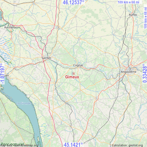
Gimeux GPS coordinates[2]
45° 38' 9.204" North, 0° 22' 7.824" West
| Map corner | latitude | longitude |
|---|---|---|
| Upper-left | 46.12537°, | -1.07197° |
| Center: | 45.63589°, | -0.36884° |
| Lower-right: | 45.1421°, | 0.33428° |
| Map W x H: | 109.3×109.3 km | = 67.9×67.9mi |
| max Lat: | 51.07786° ⇑72% North |
| Gimeux: | 45.63589° |
| min Lat: | ⇓28% South 41.3874° |
| min Long | Gimeux | max Long |
| -5.08615° | -0.36884° | 9.52242° |
| W 18.3%⇐ | ⇒81.7% E |
Elevation
Elevation of Gimeux is 22 m = 72 ft, and this is 171.7 m = 563 ft below average elevation for this country.
| Max E: |
2333 m = 7654 ft | 93.1% |
| Avg. | 193.7 m = 635 ft | |
| Gimeux | 22 m = 72 ft | |
Min E: |
-1 m = -3 ft | 6.9% |
See also: France elevation on elevation.city.
Geographical zone
Gimeux is located in North temperate zone (between Tropic of Cancer and the Arctic Circle). Distance of this North polar circle is 2326.9 km =1445.9 mi to North.| Distance of | km | miles | from Gimeux |
|---|---|---|---|
| North Pole | 4932.8 | 3065.1 | to North |
| Arctic Circle | 2326.9 | 1445.9 | to North |
| Tropic Cancer | 2468.3 | 1533.7 | to South |
| Equator | 5074.2 | 3153 | to South |


Nearby cities:
15 places around Gimeux: (largest is in red/bold)
• Angeac-Champagne
6.7 km =4.2 mi,  126°
126°
• Ars
1.3 km =0.8 mi,  309°
309°
• Châteaubernard
4.4 km =2.7 mi,  38°
38°
• Chérac
9.4 km =5.8 mi,  324°
324°
• Cognac
7.3 km =4.5 mi,  24°
24°
• Gensac-la-Pallue
9.4 km =5.8 mi,  80°
80°
• Genté
4.6 km =2.9 mi,  117°
117°
• Germignac
8.2 km =5.1 mi,  160°
160°
• Jarnac-Champagne
8.9 km =5.5 mi,  196°
196°
• Javrezac
7.3 km =4.5 mi,  11°
11°
• Merpins
5.8 km =3.6 mi,  335°
335°
• Pérignac
7.6 km =4.7 mi,  259°
259°
• Saint-Brice
8.5 km =5.3 mi,  51°
51°
• Saint-Laurent-de-Cognac
7.5 km =4.7 mi, 335°
• Salignac-sur-Charente
6.2 km =3.9 mi, 310°
Sources, notices
• [Note1] Compared only with cities in France existing in our database
• [Src1] Map data: © OpenStreetMap contributors (CC-BY-SA)
• [Src2] Other city data from geonames.org with taken over terms of usage.
• [Src3] Geographical zone / Annual Mean Temperature by Robert A. Rohde @ Wikipedia
