Cognac geodata
Cognac (Nouvelle-Aquitaine) is a seat of a third-order administrative division; located in France in Europe/Paris (GMT+2) time zone. With population of 20,868 people, there are 437 cities with bigger population in this country. Compared to other cities in France, 71% of cities are located further ↑North; 81.2% of cities are located further →East and 90.3% of cities have higher elevation than Cognac. Note1
Administrative division(s):
- Level 1: Nouvelle-Aquitaine
- Level 2: Charente
- Level 3: Arrondissement de Cognac
- Level 4: Cognac


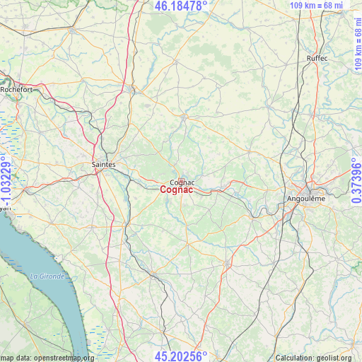
Cognac GPS coordinates[2]
45° 41' 44.988" North, 0° 19' 44.976" West
| Map corner | latitude | longitude |
|---|---|---|
| Upper-left | 46.18478°, | -1.03229° |
| Center: | 45.69583°, | -0.32916° |
| Lower-right: | 45.20256°, | 0.37396° |
| Map W x H: | 109.2×109.2 km | = 67.9×67.9mi |
| max Lat: | 51.07786° ⇑71% North |
| Cognac: | 45.69583° |
| min Lat: | ⇓29% South 41.3874° |
| min Long | Cognac | max Long |
| -5.08615° | -0.32916° | 9.52242° |
| W 18.8%⇐ | ⇒81.2% E |
Elevation
Elevation of Cognac is 29 m = 95 ft, and this is 164.7 m = 540 ft below average elevation for this country.
| Max E: |
2333 m = 7654 ft | 90.3% |
| Avg. | 193.7 m = 635 ft | |
| Cognac | 29 m = 95 ft | |
Min E: |
-1 m = -3 ft | 9.7% |
See also: France elevation on elevation.city.
Geographical zone
Cognac is located in North temperate zone (between Tropic of Cancer and the Arctic Circle). Distance of this North polar circle is 2320.3 km =1441.8 mi to North.| Distance of | km | miles | from Cognac |
|---|---|---|---|
| North Pole | 4926.2 | 3061 | to North |
| Arctic Circle | 2320.3 | 1441.8 | to North |
| Tropic Cancer | 2475 | 1537.9 | to South |
| Equator | 5080.9 | 3157.1 | to South |


Nearby cities:
15 places around Cognac: (largest is in red/bold)
• Ars
7.1 km =4.4 mi,  215°
215°
• Bourg-Charente
8.1 km =5 mi,  113°
113°
• Boutiers-Saint-Trojan
3.2 km =2 mi,  44°
44°
• Cherves-Richemont
5.6 km =3.5 mi,  342°
342°
• Châteaubernard
3.3 km =2.1 mi,  185°
185°
• Gensac-la-Pallue
8 km =5 mi,  129°
129°
• Gimeux
7.3 km =4.5 mi,  204°
204°
• Javrezac
1.7 km =1.1 mi,  285°
285°
• Merpins
5.7 km =3.5 mi,  255°
255°
• Nercillac
6.6 km =4.1 mi,  69°
69°
• Réparsac
8.1 km =5 mi,  62°
62°
• Saint-Brice
3.8 km =2.4 mi, 111°
• Saint-Laurent-de-Cognac
6.2 km =3.9 mi,  271°
271°
• Saint-Sulpice-de-Cognac
8.2 km =5.1 mi,  330°
330°
• Salignac-sur-Charente
8.2 km =5.1 mi,  251°
251°
Sources, notices
• [Note1] Compared only with cities in France existing in our database
• [Src1] Map data: © OpenStreetMap contributors (CC-BY-SA)
• [Src2] Other city data from geonames.org with taken over terms of usage.
• [Src3] Geographical zone / Annual Mean Temperature by Robert A. Rohde @ Wikipedia
